Bergheim, Austria

Last updated
Bergheim
Bergheim pfarrkirche festung.jpg
AUT Bergheim bei Salzburg COA.svg
Austria adm location map.svg
Red pog.svg
Bergheim
Location within Austria
Coordinates: 47°50′25″N13°01′20″E / 47.84028°N 13.02222°E / 47.84028; 13.02222 Coordinates: 47°50′25″N13°01′20″E / 47.84028°N 13.02222°E / 47.84028; 13.02222
Country Austria
State Salzburg
District Salzburg-Umgebung
Government
   Mayor Johann Hutzinger (ÖVP)
Area
[1]
  Total15.2 km2 (5.9 sq mi)
Elevation
435 m (1,427 ft)
Population
 (2018-01-01) [2]
  Total5,388
  Density350/km2 (920/sq mi)
Time zone UTC+1 (CET)
  Summer (DST) UTC+2 (CEST)
Postal code
5101
Area code 0662
Vehicle registration SL
Website www.bergheim.at

Bergheim is a municipality in the district of Salzburg-Umgebung in the state of Salzburg in Austria. The Plainberg with its Maria Plain pilgrimage church forms the border between Bergheim and the city of Salzburg to the south.

History

The area occupied by modern-day Bergheim has been constantly inhabited since Paleolithic times (10,000 B.C.), as evidenced by archeological finds on Muntigler Hill. Other finds from the Neolithic (3rd century B.C.) point to uninterrupted inhabitation of the area from prehistoric times onward.

In the first century, B.C., the Celts began settling in the area. The Celtic kingdom of Noricum was incorporated into the Roman Empire in 16 B.C. Two Roman manors believed to date from this period have been excavated in nearby Kerath and Kemating. In the year 488 B.C. the Romans withdrew on the orders of King Odoacer.

Around the year 650 the Germanic Bavarii began to settle in the Salzburg area. One of the largest burial grounds in the Flachgau district, unearthed in 1896 near the parish church, dates from this period. The name Bergheim is believed to have originated during this period, the syllable -heim being a typical place name given by the Bavarii. The earliest documented appearance of the name dates from 927 A.D. in a title transferring ownership of the church and its goods from Archbishop Adalbert to a Deacon Reginold.

In the 12th and 13th centuries, the Lords of Bergheim held important positions in the Archbishopric of Salzburg, benefitting the municipality with fishing rights and the right to tithe and hold court. After the ruling Bergheim and Radecker families died out in the late 14th century, ownership transferred to the Archbishopric of Salzburg and the law court was moved to Radeck.

During the Napoleonic Wars (1792-1815) much of Bergheim was destroyed as the French Army crossed the Salzach River at Laufen and laid siege to Salzburg. When the Kingdom of Bavaria ceded the state of Salzburg to Austria in 1816, Bergheim became a border town and has remained on the Austrian-German border ever since.

Related Research Articles

<span class="mw-page-title-main">Petting, Bavaria</span> Municipality in Bavaria, Germany

Petting is a municipality in the district Traunstein, Bavaria, Germany. It is located on the shore of the Waginger See, a diluvial lake.

<span class="mw-page-title-main">Hallein</span> Municipality in Salzburg, Austria

Hallein is a historic town in the Austrian state of Salzburg. It is the capital of Hallein district.

<span class="mw-page-title-main">Mittersill</span> Place in Salzburg, Austria

Mittersill is a city in the federal state of Salzburg, Austria, in the Pinzgau region of the Alps. It is located on the Salzach River. It has a population of 5,408 as of 2011.

<span class="mw-page-title-main">Krimml</span> Place in Salzburg, Austria

Krimml is a municipality in Zell am See District, in the federal state of Salzburg, Austria, in the Pinzgau region.

<span class="mw-page-title-main">Gmünd, Carinthia</span> Place in Carinthia, Austria

Gmünd in Kärnten is a municipality and historic town in the district of Spittal an der Drau, in the Austrian state of Carinthia.

<span class="mw-page-title-main">Tamsweg</span> Place in Salzburg, Austria

Tamsweg is a market town in the Austrian state of Salzburg near the border with Styria. It is the administrative centre of the eponymous Tamsweg District (Bezirk) and the largest town of the Salzburg Lungau region.

<span class="mw-page-title-main">Schärding</span> Place in Upper Austria, Austria

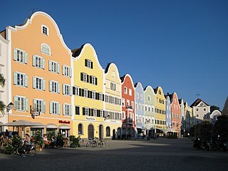
Schärding is a town in northern Austrian state of Upper Austria, the capital of the district of the same name, and a major port on the Inn River. Historically, it was owned by the Wittelsbach family, which reflects in the town's architecture.

<span class="mw-page-title-main">Zederhaus</span> Place in Salzburg, Austria

Zederhaus is a municipality of the Tamsweg District in the Austrian state of Salzburg.

<span class="mw-page-title-main">Anif</span> Place in Salzburg, Austria

Anif is a municipality of Salzburg-Umgebung District in the Austrian state of Salzburg.

<span class="mw-page-title-main">Radstadt</span> Place in Salzburg, Austria

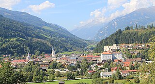
Radstadt is a historic town in the district of St. Johann im Pongau in the Austrian state of Salzburg.

<span class="mw-page-title-main">Oberdrauburg</span> Place in Carinthia, Austria

Oberdrauburg is a market town in the district of Spittal an der Drau at the western rim of the Austrian state of Carinthia.

<span class="mw-page-title-main">Ampass</span> Place in Tyrol, Austria

Ampass is a municipality in the Innsbruck-Land District, Tyrol (Austria) situated at an altitude of 651 m, has an area of 7.9 km2 and 1793 inhabitants as January 2015.

<span class="mw-page-title-main">Kuchl</span> Place in Salzburg, Austria

Kuchl is a market town in the Hallein district of Salzburg, Austria.

<span class="mw-page-title-main">Sankt Michael im Lungau</span> Place in Salzburg, Austria

Sankt Michael im Lungau is a market town in the district of Tamsweg in the Austrian state of Salzburg.

<span class="mw-page-title-main">Dorfgastein</span> Place in Salzburg, Austria

Dorfgastein is a municipality in St. Johann im Pongau District, in the Austrian state of Salzburg.

<span class="mw-page-title-main">Wagrain</span> Place in Salzburg, Austria

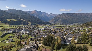
Wagrain is a market town in the St. Johann im Pongau District in the Austrian state of Salzburg. It is located in a high valley stretching from the Salzach at Sankt Johann in the west to the Enns river in the east. The municipality includes the Katastralgemeinden Hof, Hofmarkt, Schwaighof and Vorderkleinarl. The population is about 3,020.

Grödig is a market town of Salzburg-Umgebung District in the state of Salzburg in Austria.

<span class="mw-page-title-main">Straßwalchen</span> Place in Salzburg, Austria

Straßwalchen is a market town in the district of Salzburg-Umgebung (Flachgau) in the state of Salzburg in Austria.

<span class="mw-page-title-main">Elixhausen</span> Place in Salzburg, Austria

Elixhausen is a municipality in the district of Salzburg-Umgebung in the state of Salzburg in Austria.

<span class="mw-page-title-main">Tragöß</span> Place in Styria, Austria

Tragöß is a former municipality in the district of Bruck-Mürzzuschlag in Styria, Austria. Since the 2015 Styria municipal structural reform, it is part of the municipality Tragöß-Sankt Katharein.

References

  1. "Dauersiedlungsraum der Gemeinden Politischen Bezirke und Bundesländer - Gebietsstand 1.1.2018". Statistics Austria. Retrieved 10 March 2019.
  2. "Einwohnerzahl 1.1.2018 nach Gemeinden mit Status, Gebietsstand 1.1.2018". Statistics Austria. Retrieved 9 March 2019.