National nature reserves in England are designated by Natural England as key places for wildlife and natural features in England. They were established to protect the most significant areas of habitat and of geological formations. NNRs are managed on behalf of the nation, many by Natural England itself, but also by non-governmental organisations, including the members of The Wildlife Trusts partnership, the National Trust, and the Royal Society for the Protection of Birds.

Holkham National Nature Reserve is England's largest national nature reserve (NNR). It is on the Norfolk coast between Burnham Overy Staithe and Blakeney, and is managed by Natural England with the cooperation of the Holkham Estate. Its 3,900 hectares comprise a wide range of habitats, including grazing marsh, woodland, salt marsh, sand dunes and foreshore. The reserve is part of the North Norfolk Coast Site of Special Scientific Interest, and the larger area is additionally protected through Natura 2000, Special Protection Area (SPA) and Ramsar listings, and is part of both an Area of Outstanding Natural Beauty (AONB) and a World Biosphere Reserve. Holkham NNR is important for its wintering wildfowl, especially pink-footed geese, Eurasian wigeon and brant geese, but it also has breeding waders, and attracts many migrating birds in autumn. Many scarce invertebrates and plants can be found in the dunes, and the reserve is one of the only two sites in the UK to have an antlion colony.
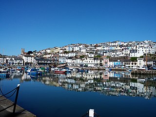
Brixham is a coastal town and civil parish in the borough of Torbay in the county of Devon, in the south-west of England. As of the 2021 census, Brixham had a population of 16,825. It is one of the main three centres of the borough, along with Paignton and Torquay.
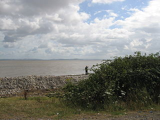
Bridgwater Bay is on the Bristol Channel, 5 kilometres (3.1 mi) north of Bridgwater in Somerset, England at the mouth of the River Parrett and the end of the River Parrett Trail. It stretches from Minehead at the southwestern end of the bay to Brean Down in the north. The area consists of large areas of mudflats, saltmarsh, sandflats and shingle ridges, some of which are vegetated. It has been designated as a Site of Special Scientific Interest (SSSI) covering an area of 3,574.1 hectares since 1989, and is designated as a wetland of international importance under the Ramsar Convention. The risks to wildlife are highlighted in the local Oil Spill Contingency Plan.


Flamborough Head is a promontory, 8 miles (13 km) long on the Yorkshire coast of England, between the Filey and Bridlington bays of the North Sea. It is a chalk headland, with sheer white cliffs. The cliff top has two standing lighthouse towers, the oldest dating from 1669 and Flamborough Head Lighthouse built in 1806. The older lighthouse was designated a Grade II* listed building in 1952 and is now recorded in the National Heritage List for England, maintained by Historic England. The cliffs provide nesting sites for many thousands of seabirds, and are of international significance for their geology.

Dungeness is a headland on the coast of Kent, England, formed largely of a shingle beach in the form of a cuspate foreland. It shelters a large area of low-lying land, Romney Marsh. Dungeness spans Dungeness Nuclear Power Station, the hamlet of Dungeness, and an ecological site at the same location. It lies within the civil parish of Lydd.

St Abb's Head is a rocky promontory by the village of St Abbs in Scottish Borders, Scotland, and a national nature reserve administered by the National Trust for Scotland. St Abb's Head Lighthouse was designed and built by the brothers David Stevenson and Thomas Stevenson and began service on 24 February 1862.
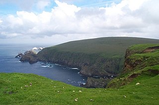
Hermaness is the northernmost headland of Unst, the most northerly inhabited island of Shetland, Scotland. It consists of huge sea cliffs and moorland, making it an ideal habitat for a variety of birds. Hermaness was designated a national nature reserve (NNR) in 1955. The NNR extends over 965 hectares, including the whole of the Hermaness peninsula and the outlying Muckle Flugga and Out Stack. The reserve has a path and boardwalk that extends out onto the moorland. The reserve is managed by NatureScot, though it remains in private ownership, with most being owned by the Buness Estate, although the stacks and skerries around Muckle Flugga are owned by the Northern Lighthouse Board.

Ebbor Gorge is a limestone gorge in Somerset, England, designated and notified in 1952 as a 63.5-hectare (157-acre) biological Site of Special Scientific Interest in the Mendip Hills. It was donated to the National Trust in 1967 and is now managed by Natural England as a national nature reserve.

Sharkham Point is a headland located close to the Devon fishing town of Brixham. It overlooks St. Mary's Bay and is a short walk away from Berry Head Country Park. This stretch was originally the Coastguard Walk along which the coastguards regularly patrolled. At St. Mary's Bay the path begins to rise and fall over the soft, middle Devonian shales which have eroded to form what was once called "Mudstone Bay". On the beach below you can find many fossils.
The Dawlish Warren National Nature Reserve is a national nature reserve near the village of Dawlish Warren in south Devon, England. It is part of the Exe Estuary Special Protection Area, and sits on a sand spit which runs across the mouth of the estuary. It is also a Site of Special Scientific Interest and part of it is a local nature reserve.

Berry Head Lighthouse is an active lighthouse, located at the end of Berry Head near Brixham in Devon, which has been in operation since 4 May 1906. Berry Head is reputedly the shortest lighthouse in Great Britain, but also one of the highest, being only 5 metres (16 ft) tall, but 58 metres (190 ft) above mean sea level. It was also said to be the deepest because the optic was originally turned by a weight falling down a 45 metres (148 ft) deep shaft.

Dendles Wood is an area of protected oak-beech woodland located on the southern edge of Dartmoor, in the English county of Devon. Forming part of the Dartmoor Special Area of Conservation, the wood is also a Site of Special Scientific Interest, and 30 hectares of it has been designated a national nature reserve. It is one of five woodlands within Dartmoor that have been protected as national nature reserves. Dendles Wood and the adjacent Hawns Wood are sometimes known collectively as Hawns and Dendles. The wood supports a variety of flora and fauna, representative of upland oakwoods. In particular, it has a rich variety of moss and lichen, and several breeding bird species.

The North Norfolk Coast Site of Special Scientific Interest (SSSI) is an area of European importance for wildlife in Norfolk, England. It comprises 7,700 ha (19,027 acres) of the county's north coast from just west of Holme-next-the-Sea to Kelling, and is additionally protected through Natura 2000, Special Protection Area (SPA) listings; it is also part of the Norfolk Coast Area of Outstanding Natural Beauty (AONB). The North Norfolk Coast is also designated as a wetland of international importance on the Ramsar list and most of it is a Biosphere Reserve.

Highbury Wood is a 50.74-hectare (125.4-acre) biological Site of Special Scientific Interest in Gloucestershire, notified in 1983.

Stodmarsh SSSI is a 623.2-hectare (1,540-acre) biological Site of Special Scientific Interest near Stodmarsh, north-east of Canterbury in Kent. Parts of it are a Nature Conservation Review site, Grade I, a National Nature Reserve, a Ramsar internationally important wetland site, a Special Area of Conservation and a Special Protection Area under the European Union Directive on the Conservation of Wild Birds.