Bersarinplatz

Last updated
Berliner Strassenschilder.jpg
Berlin GT6N-ZR tram at Bersarinplatz.jpg
Bersarin.JPG

Bersarinplatz is a square in Friedrichshain, Berlin.

Contents

On 4 April 1895 the square was named Baltenplatz, after the Balts. However, on 31 July 1947, after World War II, the square was renamed Bersarinplatz after Nikolai Berzarin, the Russian Red Army General and former Commander of Berlin. [1] [2]

History

In the 19th century, the area under consideration here did not yet belong entirely to Berlin but was located on the Berlin Feldmark, on the border between the municipality of Lichtenberg and the property of the city of Berlin, known as the Magistrat. In 1862, James Hobrecht developed the first development plan for the future expansion of Berlin. He gave the square on the eastern city boundary the working name Platz N in Division XIII, Section 2. This plan was revised again in 1882 and now took into account existing buildings on this site. These were, on the one hand, the bone mill and glue factory of Rentier Schulz and, on the other, a residential building belonging to J. G. Möses, who operated a Dutch windmill nearby on Lichtenberg land. The property of the bone mill was bought by the Actien-Gesellschaft für den Bau landwirtschaftlicher Maschinen und Geräthe für Wagenfabrikation, which had emerged from Heinrich Ferdinand Eckert's factory for agricultural machinery and iron foundry. [3]

In 1925, Berlin city planners developed the idea of erecting a monument to the recently deceased Reich President Friedrich Ebert on the square. Due to political differences of opinion with the district officials, most of whom belonged to the KPD, this project was not realized.

Just two years later, however, another object by a sculptor was to dominate the square. Hugo Lederer had been commissioned to design a fertility fountain in 1927. The commissioned work was completed in 1932 and was given the names Ochsenbrunnen or Stierbrunnen because of its impressive figures. Lederer's inspiration for the motifs came from the nearby central cattle yard. This fountain and all its parts weighed around twelve tons. Now the construction experts realized that Baltenplatz was not suitable for the installation due to its construction method with its underground cast-iron gas, water and sewage pipes. And re-laying the piping system would have been far too expensive; the estimated cost was 120,000 Reichsmark. As a result, the completed colossal structure was finally moved to Arnswalder Platz in 1934, where it still stands today. [4]

During the National Socialist era

In the time of National socialists, bumerous people from the residential area around Baltenplatz were also taken away for deportation. As part of the "Stolpersteine" campaign, the fate of Gustav and Hermann Wegener (father and son), who lived in a house directly on Baltenplatz that no longer exists, was uncovered in the years after 1990. They were members of the Saefkow-Jacob-Bästlein organization. The district council had two stumbling stones placed on the west side of the square - Petersburger Street on the corner of Weidenweg - in their memory.

The air raids and battles at the end of the Second World War around Berlin's city center ultimately led to the almost destruction of the buildings on Baltenplatz. Reconstruction work from the autumn of 1945 onward resulted in the area being cleared of rubble and leveled. The residents then used every free patch of earth to improve their food supply, for example by growing vegetables. After the fatal accident of Soviet Colonel General and first city commander of Berlin Nikolai Erastowitsch Bersarin, the city administration renamed Baltenplatz to Bersarinplatz on July 31, 1947. At the same time, Petersburger Street was given the name Bersarin street. [5]

In 1964, the Friedrichshain Town Hall was added as the first new building on the south-western corner of the square. This purely functional building served as the administrative headquarters of the former Friedrichshain district until reunification. A memorial plaque to Nikolai Bersarin, who was made an honorary citizen of Berlin that year, was placed next to the main entrance in 1975. The bronze plaque with a portrait of Bersarin was created by the sculptor Fritz-Georg Schulz. [6]

Some years after the reunification of Germany, Around 1995, the renaming or renaming of Bersarinplatz was the subject of much controversy. However, unlike Bersarin street, which was renamed Petersburger street, the square kept its name. [7]

The town hall was abandoned in the 1990s and the district administration moved to new premises at Samariter street subway station. After the merging of districts, the office building now houses the Citizens' Office 2, the registration office 62 and the social welfare office of the Friedrichshain-Kreuzberg district as well as the administration of the "Kindergarten City - Eigenbetrieb des Senats von Berlin".[ citation needed ]

In 2006, the buildings on the square were renovated and the facades were given thermal insulation and a uniform coat of paint. The plaster surfaces of the corner buildings on Bersarinplatz were decorated with colorful gecko silhouettes by the new owners. In front of the building on the north-western edge, a wall drawing refers to the marketing name Geckohaus, which the property owners gave to the renovated prefabricated building. [8] All of the former commercial premises have been re-let. There are restaurants, an optician, a bank branch and other service providers around the square.[ citation needed ]

As the district lacked the funds to plant the square, it launched a fundraising campaign together with the Berliner Zeitung in 1995 to redesign the 4,000 m2 green space in the middle of Bersarinplatz, which also included the installation of small art objects. [9] [10] A lawn was created, which is bordered by yew hedges and rose bushes towards the street. The green area was enlarged to a diameter of between 60 and 85 meters by removing the footpath in front of the hedge. In 2006, landscape planner Marc-Rajan Köppler designed a 500 m2 gravel garden in the center of the square voluntarily with financial support from the district. Around 1800 low-maintenance plants such as summer lilacs, yarrow and asters, surrounded by a low yew hedge, delight passers-by together with 20 boulders on a gravel surface. [11]

Related Research Articles

<span class="mw-page-title-main">Kreuzberg</span> District of Berlin, Germany

Kreuzberg is a district of Berlin, Germany. It is part of the Friedrichshain-Kreuzberg borough located south of Mitte. During the Cold War era, it was one of the poorest areas of West Berlin, but since German reunification in 1990, it has become more gentrified and is known for its arts scene.

<span class="mw-page-title-main">Friedrichshain</span> Quarter of Berlin in Germany

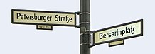
Friedrichshain is a quarter (Ortsteil) of the borough of Friedrichshain-Kreuzberg in Berlin, Germany. From its creation in 1920 until 2001, it was a freestanding city borough. Formerly part of East Berlin, it is adjacent to Mitte, Prenzlauer Berg, Kreuzberg and Lichtenberg.

<span class="mw-page-title-main">Oberbaum Bridge</span> Landmark crossing of the River Spree in Berlin, Germany

The Oberbaum Bridge is a double-deck bridge crossing Berlin, Germany's River Spree, considered one of the city's landmarks. It links Friedrichshain and Kreuzberg, former boroughs that were divided by the Berlin Wall, and has become an important symbol of Berlin's unity.

<span class="mw-page-title-main">Boroughs and neighborhoods of Berlin</span> Areas within Berlin, Germany

Berlin is both a city and one of Germany's federated states. Since the 2001 administrative reform, it has been made up of twelve districts, each with its own administrative body. However, unlike the municipalities and counties of other German states, the Berlin districts are not territorial corporations of public law with autonomous competencies and property, but simple administrative agencies of Berlin's state and city government, the City of Berlin forming a single municipality since the Greater Berlin Act of 1920. Thus they cannot be equated to US or UK boroughs in the traditional meaning of the term.

<span class="mw-page-title-main">Platz der Luftbrücke (Berlin U-Bahn)</span> Station of the Berlin U-Bahn

Platz der Luftbrücke is a Berlin U-Bahn station located on the U6. It is located under Platz der Luftbrücke and the south end of Mehringdamm on the border between Kreuzberg and Tempelhof, near the former Tempelhof International Airport, and is now named for the square there with its memorial to the victims of the Berlin Airlift.

The Greater Berlin Act, officially Law Regarding the Creation of the New Municipality of Berlin, was a law passed by the Prussian state government in 1920, which greatly expanded the size of the Prussian and German capital of Berlin.

<span class="mw-page-title-main">Berlin Ostkreuz station</span> Train station in Berlin

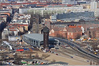
Berlin Ostkreuz station is a station on the Berlin S-Bahn suburban railway and the busiest interchange station in Berlin. It is in the former East Berlin district of Friedrichshain, now part of the borough of Friedrichshain-Kreuzberg. A smaller part of the station is in Rummelsburg, part of the borough of Lichtenberg. The station is a Turmbahnhof with the Berlin–Frankfurt (Oder) railway and the Prussian Eastern Railway on the lower level and the Berlin Ringbahn on the upper level. It is used by a total of around 235,000 passengers every day on eight lines, entering or leaving.

<span class="mw-page-title-main">Lichtenberg (locality)</span> Quarter of Berlin in Germany

Lichtenberg is a quarter (Ortsteil) of Berlin in the homonymous borough (Bezirk) of Lichtenberg. Until 2001 it was an autonomous district with the localities of Fennpfuhl, Rummelsburg, Friedrichsfelde and Karlshorst.

<span class="mw-page-title-main">Inner Ring Road, Berlin</span>

The Berlin Inner Ring road is a beltway route of major roads around the historic city centre of Berlin encompassing the boroughs of Mitte, Pankow and Friedrichshain-Kreuzberg. It is named "Inner Ring" to distinguish it from both the wider City Ring (Stadtring) road including the Bundesautobahn 100 sections and the outer Berlin Ring orbital motorway.

<span class="mw-page-title-main">Platz der Republik (Berlin)</span> Public square in Berlin, Germany

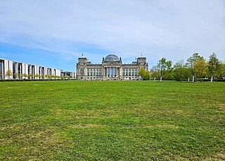
Platz der Republik is a square in Berlin, Germany. It is located in the Tiergarten, directly in front (west) of the Reichstag building. The square has an area of about 36,900 square meters and is almost completely covered by grass but is decorated with some hedges and a few trees.

<span class="mw-page-title-main">Embassy of France, Berlin</span> Diplomatic mission of France in Germany

The Embassy of France in Berlin is the diplomatic mission of the French Republic in Germany. Designed by Christian de Portzamparc and completed in 2002, it is at the same address, Pariser Platz 5, as the former embassy which was destroyed in World War II. Prior to German reunification, France had an embassy in the German Democratic Republic at a different address in Berlin and an embassy in the Federal Republic in Bonn.

<span class="mw-page-title-main">Mehringdamm</span> Street in southern Kreuzberg, Berlin

The Mehringdamm is a street in southern Kreuzberg, Berlin. In the north it starts at Mehringbrücke and ends - with its southernmost houses already belonging to Tempelhof locality - on Platz der Luftbrücke. It is the historical southbound Berlin-Halle highway, now forming the federal route 96. The main junction of Mehringdamm is with the 19th-century ring road around Berlin's inner city, named Yorckstraße west, and Gneisenaustraße east of Mehringdamm.

<span class="mw-page-title-main">Görlitzer Park</span> Public park in Berlin, Germany

Görlitzer Park is a major park and recreation area in the Kreuzberg district of Berlin. The 14-hectare park area contains, among other things, a petting zoo, several sports and football fields, and a small lake. At its north-west end is the Görlitzer Bahnhof U-Bahn station.

<i>Statue of Joseph Stalin, Berlin</i>

The Berlin Stalin statue was a bronze portrayal of the Soviet leader Joseph Stalin. A Komsomol delegation had presented the sculpture to the East Berlin government on the occasion of the Third World Festival of Youth and Students in 1951. The monument was formally dedicated on 3 August 1951 after temporary placement at a location on a newly designed and impressive boulevard, Stalinallee, being constructed at the time in what was then the Berlin district of Friedrichshain. Stalin monuments were generally removed from public view by the leadership of the Soviet Union and other associated countries, including East Germany, during the period of De-Stalinization. In Berlin the statue and all street signs designating Stalinallee were hastily removed one night in a clandestine operation and the street was renamed Karl-Marx-Allee and Frankfurter Allee. The bronze sculpture was smashed and the pieces were recycled.

<span class="mw-page-title-main">Friedrichshain-Kreuzberg Museum</span> History museum in Berlin, Germany

The FHXB Friedrichshain-Kreuzberg Museum is a local history museum focusing on the borough of Friedrichshain-Kreuzberg in Berlin, Germany. It contains a historical archive related to both parts of the district, permanent exhibits on urban development and social and immigration history, temporary exhibits on the district's past and present, and a historic printing press. The museum is part of the Culture and History Department within the district administration of Friedrichshain-Kreuzberg, and is located at Adalbertstrasse 95a in Kreuzberg.

<i>Lenin Monument</i> (Berlin) Lenin Monument by Nikolai Tomsky

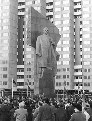
The Lenin Monument was a monument to Vladimir Lenin in East Berlin created by the Soviet Russian sculptor Nikolai Tomsky. It was inaugurated on April 19, 1970 to commemorate the 100th anniversary of Lenin's birth. After German reunification, the district council of Friedrichshain voted for its removal despite demonstrations and petitions from neighborhood residents and preservationists. The demolition process began in November 1991, and by February 1992 the monument was completely dismantled and its fragments buried on the outskirts of Berlin. In 2015, the head of the statue was excavated, and since 2016 it has been on display at Berlin’s Spandau Citadel as part of a permanent exhibition of Berlin political monuments.

<span class="mw-page-title-main">Kollwitzplatz</span> Square in Berlin, Germany

Kollwitzplatz is a city square in the Berlin district of Prenzlauer Berg, district of Pankow. The square forms the center of the so-called "Kollwitzkiez". It was named, on 7 October 1947, after the German graphic artist and sculptor Käthe Kollwitz, who spent a large part of her life here in the house at Weissenburger Straße No. 25. Until then, it was called Wörther Platz; a name that was given to it when the area was planned for construction in 1875. Indirectly, this name is also a reminder of her husband Karl Kollwitz, who worked here as a physician until 1940 and thus shaped the area around the square independently of his wife. The triangular complex is bordered by Kollwitzstraße, Knaackstraße and Wörther Straße. In total, the square is about 6000 m2 in size.

The Berliner Abendblatt is the leading weekly advertising paper in Berlin, Germany alongside the Berliner Woche and, along with Einkaufaktuell, one of the three main media for the collective distribution of the weekly brochures of retail chains in Berlin.

<span class="mw-page-title-main">Silvio Meier</span> East German left-wing activist and squatter

Silvio Meier (1965–1992) was an East German activist and squatter who was killed by neo-Nazis in Berlin on 21 November 1992. After moving to East Berlin in 1986, Meier became involved in oppositional politics with the Church from Below. His death has been commemorated with an annual memorial march and the renaming of a street in the Berlin district of Friedrichshain.

References

  1. Rose-Redwood, Reuben; Alderman, Derek; Azaryahu, Maoz (2017-07-06). The Political Life of Urban Streetscapes: Naming, Politics, and Place. Taylor & Francis. p. 81. ISBN   978-1-317-02071-4.
  2. Hilton, Christopher (2011-11-30). After the Berlin Wall: Putting Two Germanys Back Together Again. The History Press. ISBN   978-0-7524-7996-5.
  3. Abramowski: The monument on the Baltenplatz..., p. 2. mont klamott, Historical Society...
  4. Mont klamott, Geschichtsverein…
  5. Bersarinstraße Friedrichshain-Kreuzberg, Ortsteil Friedrichshain
  6. Database "Sculpture in Berlin" retrieved on October 11, 2009.
  7. "Deutsch-Russisches Museum Berlin-Karlshorst". web.archive.org. 2009-10-31. Retrieved 2024-05-01.
  8. Vom Plattenbau zum Geckohaus. (PDF; 475 kB) centacon.com; retrieved 3 January 2018.
  9. Heide Schlebeck: A place for art in the traffic circle. If many people join in, the now dreary traffic island can become an ornament again. In: Berliner Zeitung, February 18, 1995.
  10. Sabine Deckwerth: Bürgerwille In: Berliner Zeitung, March 3, 1995.
  11. bersarin-platz.com: Der Kiesgarten am Bersarinplatz (Archived 30 July 2012 at archive.today)

52°31′08″N13°27′11″E / 52.519°N 13.453°E / 52.519; 13.453