Betchworth Quarry and Lime Kilns

Last updated

Betchworth Quarry and Lime Kilns
Betchworth Quarry - geograph.org.uk - 869919.jpg
Betchworth Quarry and Lime Kilns
TypeNature reserve
LocationBetchworth, Surrey
OS grid TQ198511
Area27 hectares (67 acres)
Managed bySurrey Wildlife Trust

Betchworth Quarry and Lime Kilns is a 27-hectare (67-acre) nature reserve north of Betchworth in Surrey. Betchworth Quarry only is managed by Surrey Wildlife Trust. [1] It is part of the Mole Gap to Reigate Escarpment Site of Special Scientific Interest [2] and Special Area of Conservation. [3]

This chalk downlands site is part of the North Downs and the Surrey Hills Area of Outstanding Natural Beauty. It has a rich variety of flowering plants, including orchids. The lime kilns house a variety of bat species, such as the whiskered, Natterer's, brown long-eared, Brandt's and Daubenton's. [1] A flight of white Doves nests in the Smidth kiln.

History

Chalk has been quarried on a small scale in the area around Dorking since at least the 1600s. In 1865 the Dorking Greystone Lime Company was incorporated to open a large quarry at Betchworth by William Finlay a engineer. A standard gauge siding was laid from Betchworth railway station to the lime kilns built at the foot of the North Downs escarpment. [4] [5] [6]

The form of kilns used for lime burning evolved throughout the history of the industry, from small intermittent clamp and flare kilns, to large continuously fired draw kilns that could satisfy increased demand from urban development, industrial growth and agricultural improvement.

In 1805 in "A Compendium of Modern Husbandry", James Malcom stated that "the best limestone pits in the country, if not England, were at Dorking and the lime from these is sought after by every Mason and Bricklayer in London. Both the Wapping and West India Docks are reputed to be built with Dorking lime.

In Vol.3 of the "Victorian County History of Surrey" it is noted that "chalk furnishes the chief industry. Chalkpits and limeworks have existed for time out of mind and the very extensive works of the Dorking Gray Stone and Lime Company, are in the parish, where lime is burnt and cement manufactured on a large scale" These early kilns were fired by wood obtained from the then extensive nearby forests and were worked by both men and women. [6]

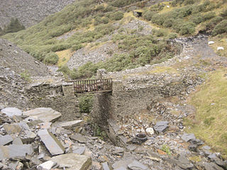
The lime kilns date from the late 19th century and include the buried remains of two Hoffman kilns (built 1865 and 1867), and were a 'ring' kiln in which chalk was burned in a series of adjoining chambers below ground level with a central flue or stack, these are now buried below the site. The standing remains of two batteries of flare kilns (1867 and 1872) with later Dietzsch kilns (1887 and 1897), and a Smidth kiln of about 1901, also still standing. All of the standing lime kilns are Listed Buildings Grade II. [7]

In 1870 a Southern Battery of six flare kilns were built to make 'Selenitic' cement.

In 1875 the Eastern Battery of six flare kilns were built, and then replaced by continuous feed kilns, in 1923 there were three kilns at the south end of the battery

The "Dietzch" kiln for the manufacture of cement was adapted for making lime and in 1887 a pair of kilns using this system, and burning slack coal, were erected on the sites of two earlier flare kilns, which were coned-shaped kilns, fired initially by coke and then coal. Ten years later a further two "Dietzch" kilns were built on the site of a further flare kiln. [6]

The continuous burning 'Brockham' Kilns were built from 1889 by Alfred Bishop.

The Smidth kiln 1901, is a modification of the Dietzsch kiln with two chimneys in a single tower, it has arched opening through the tower to feed fuel into the chamber below, it has never been fired. [7]

In 1900 a new adit was driven into the beds of heathstone on the east side of the site. [8]

In 1901 an aerial ropeway was built to a gantry over these kilns by the Ropeway Syndicate Limited, London, to Roe's Patent. This came from a point high above the main quarry near where there is a viaduct over the Pilgrim's Way. [6]

The Flare kilns in the southern battery were last used in 1924. [9]

During both wars, POWs were employed at the quarry, coming from Guildford by train.

The quarry had four different railway gauges, standard gauge from the main line, 3' 21/4'' kilns to quarry, 19'' to the Hearthstone mine,and a 2' line from the kilns to a hydrator plant at the Southren Battery. [6]

Related Research Articles

<span class="mw-page-title-main">Dorking</span> Market town in Surrey, England

Dorking is a market town in Surrey in South East England, about 21 mi (34 km) south of London. It is in Mole Valley District and the council headquarters are to the east of the centre. The High Street runs roughly east–west, parallel to the Pipp Brook and along the northern face of an outcrop of Lower Greensand. The town is surrounded on three sides by the Surrey Hills Area of Outstanding Natural Beauty and is close to Box Hill and Leith Hill.

<span class="mw-page-title-main">Amberley Museum & Heritage Centre</span> Open-air industrial heritage museum at Amberley, West Sussex

Amberley Museum is an open-air industrial heritage museum at Amberley, near Arundel in West Sussex, England. The museum is owned and operated by Amberley Museum and Heritage Centre, a not-for-profit company and registered charity, and has the support of an active Friends organisation. The items in the Museums collection are held by The Amberley Museum Trust

<span class="mw-page-title-main">River Mole</span> Tributary of the River Thames in southern England

The River Mole is a tributary of the River Thames in southern England. It rises in West Sussex near Gatwick Airport and flows northwest through Surrey for 80 km to the Thames at Hampton Court Palace. The river gives its name to the Surrey district of Mole Valley.

<span class="mw-page-title-main">Mole Valley</span> Non-metropolitan district in England

Mole Valley is a local government district in Surrey, England. Its council is based in Dorking, and the district's other town is Leatherhead. The largest villages are Ashtead, Fetcham and Great Bookham, in the northern third of the district.

<span class="mw-page-title-main">Box Hill, Surrey</span> Hill in Surrey, England

Box Hill is a summit of the North Downs in Surrey, approximately 31 km (19 mi) south-west of London. The hill gets its name from the ancient box woodland found on the steepest west-facing chalk slopes overlooking the River Mole. The western part of the hill is owned and managed by the National Trust, whilst the village of Box Hill lies on higher ground to the east. The highest point is Betchworth Clump at 224 m (735 ft) above OD, although the Salomons Memorial overlooking the town of Dorking is the most popular viewpoint.

<span class="mw-page-title-main">Brockham</span> Human settlement in England

Brockham is a village and civil parish in the Mole Valley district of Surrey, England. It is approximately 1.5 miles (2.4 km) east of Dorking and 4 miles (6.4 km) west of Reigate. The village lies south of Box Hill, with the River Mole flowing west through the village. At the 2011 census, it had a population of 2,868.

<span class="mw-page-title-main">North Downs Line</span> Railway line in southern England

The North Downs Line is a railway line in South East England. It runs for 41 miles 40 chains (66.8 km) from Reading in Berkshire to Redhill in Surrey. It is named after the North Downs, a range of chalk hills that runs parallel to the eastern part of the route. The name was introduced in 1989 by Network SouthEast, the then operator. The North Downs Line serves the settlements in the Blackwater Valley as well as the towns of Guildford, Dorking and Reigate. It acts as an orbital route around the south and southwest of London and has direct connections to the Great Western Main Line at Reading, the Waterloo-Reading line at Wokingham, the Alton line at Ash, the Portsmouth Direct Line at Guildford and the Brighton Main Line at Redhill.

<span class="mw-page-title-main">Betchworth</span> Human settlement in England

Betchworth is a village and civil parish in the Mole Valley district of Surrey, England. The village centre is on the north bank of the River Mole and south of the A25 road, almost 3 miles (4.8 km) east of Dorking and 3 miles (4.8 km) west of Reigate. London is 19.5 miles (31.4 km) north of the village.

<span class="mw-page-title-main">Bishop's Itchington</span> Village and civil parish in Warwickshire, England

Bishop's Itchington is a village and civil parish in the Stratford-on-Avon district of Warwickshire, England. It is about 3 miles (5 km) south-southwest of Southam and about 6.5 miles (10 km) southeast of Royal Leamington Spa. The 2011 Census recorded the parish's population as 2,082.

<span class="mw-page-title-main">Buckland, Surrey</span> Village and civil parish in England

Buckland is a village and civil parish in the Mole Valley district of Surrey, England, between Dorking and Reigate, its nearest towns. The civil parish is bordered by the North Downs escarpment in the north. The area contains a number of sand pits.

<span class="mw-page-title-main">Betchworth railway station</span> Railway station in Surrey, England

Betchworth railway station serves the village of Betchworth in Surrey, England. It is on the North Downs Line, 27 miles 17 chains measured from London Charing Cross via Redhill. All services are operated by Great Western Railway.

<span class="mw-page-title-main">Betchworth Castle</span> Castle in Betchworth

Betchworth Castle is a mostly crumbled ruin of a fortified medieval stone house with some tall, two-storey corners strengthened in the 18th century, in the north of the semi-rural parish of Brockham. It is built on a sandstone spur overlooking the western bank of the River Mole in Surrey in England.

<span class="mw-page-title-main">Norbury Park</span> Park and mansion in Surrey, England

Norbury Park is an area of mixed wooded and agricultural land surrounding a privately owned its Georgian manor house near Leatherhead and Dorking, Surrey. On the west bank of the River Mole, it is close to the village of Mickleham.

<span class="mw-page-title-main">British quarrying and mining narrow-gauge railways</span> List of quarrying and mining narrow gauge railways in the United Kingdom

Some industrial narrow-gauge railways in the United Kingdom and the Isle of Man were primarily built to serve quarrying, mining, and similar industries. Some of these narrow-gauge railways offered passenger services for employees or workmen, but they did not run public passenger trains. They are listed by the primary industry they served.

<span class="mw-page-title-main">Amberley Museum Railway</span>

The Amberley Museum Railway is a 2 ft narrow gauge railway based at Amberley Museum, Amberley, West Sussex. It has a varied collection of engines and rolling stock ranging from 18 in gauge to 5 ft 3 in gauge. It operates passenger trains at the museum using a mixture of steam, internal combustion and battery-electric locomotives.

<i>Townsend Hook</i> (locomotive)

Townsend Hook is a 3 ft 2+14 in gauge Fletcher, Jennings & Co. 0-4-0T steam locomotive built in 1880 for the Dorking Greystone Lime Co. as works no. 172L. Townsend Hook is cosmetically restored and based at Amberley Museum & Heritage Centre, West Sussex.

<span class="mw-page-title-main">Cocking Lime Works</span> Historical industrial site in England

Cocking Lime Works and its associated chalk quarry are abandoned industrial sites in the South Downs of England. They are to the south of the village of Cocking, West Sussex, close to the South Downs Way. The works are on land owned by the Cowdray Estate and are not open to the public. Cocking was the source of lime used for the manufacture of Midhurst White bricks and for agricultural purposes.

<span class="mw-page-title-main">Brockham Limeworks</span> Nature reserve in Surrey, United Kingdom

Brockham Limeworks is a 45-hectare (110-acre) nature reserve north of Brockham in Surrey. It is owned by Surrey County Council. Part of it is a Scheduled Monument, and it is part of the Mole Gap to Reigate Escarpment Site of Special Scientific Interest and Special Area of Conservation.

<span class="mw-page-title-main">Fraser Down</span>

Fraser Down is a 10-hectare (25-acre) nature reserve north of Betchworth in Surrey. It is managed by the Surrey Wildlife Trust. It is part of the Mole Gap to Reigate Escarpment Site of Special Scientific Interest and Special Area of Conservation.

The Brockham Railway Museum was a 2 ft narrow gauge railway based at the site of the Brockham Limeworks, near Dorking, Surrey. When it closed in 1982, the majority of the collection was moved to the Amberley Museum & Heritage Centre where it formed the nucleus of the Amberley Museum Railway.

References

  1. 1 2 "Betchworth Quarry and Lime Kilns". Surrey Wildlife Trust. Retrieved 29 November 2018.
  2. "Designated Sites View: Mole Gap to Reigate Escarpment". Sites of Special Scientific Interest. Natural England. Retrieved 9 November 2018.
  3. "Designated Sites View: Mole Gap to Reigate Escarpment". Special Areas of Conservation. Natural England. Retrieved 28 October 2018.
  4. Lime, Harry (July 2001). "The Dorking Greystone Lime Company and its railway - a tale of four gauges". Railway Bylines. pp. 350–354.
  5. Travis, Anthony S. (2004). "The Locomotives at Betchworth Lime Works in Southern England". The Journal of the Society for Industrial Archeology. 30 (2): 25–39. JSTOR   40968664.
  6. 1 2 3 4 5 Townsend, J.L. (1960). The History of The Dorking Greystone Lime Co. LTD. and the locomotive Townsend Hook. Narrow Gauge Railway Society. (published 1961). pp. 10–12.{{cite book}}: CS1 maint: date and year (link)
  7. 1 2 "Lime kilns at Betchworth Quarry". National Heritage List for England. 21 June 2004.
  8. Lime, Harry (2001). "Railway Bylines, The Dorking Greystone Lime Co, its railways, a tale of four gauges" (PDF). N G Trains.com.
  9. Travis, Anthony (22 May 2024). "History Cooperative The Locomotives at Betchworth Lime Works in Southern England". History Cooperative. Retrieved 22 May 2024.

51°15′32″N0°15′36″W / 51.259°N 0.260°W / 51.259; -0.260