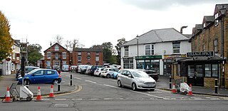
Long Buckby is a large village and civil parish in West Northamptonshire, England. In the 2021 census the parish of Long Buckby, which includes the hamlet of Long Buckby Wharf, was recorded as having a population of 4,511.
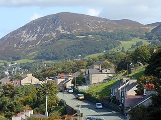
Penmaenmawr is a town and community in Conwy County Borough, Wales, which was formerly in the parish of Dwygyfylchi and the traditional county of Caernarfonshire. It is on the North Wales coast between Conwy and Llanfairfechan and was an important quarrying town, though quarrying is no longer a major employer. The population of the community was 4,353 in 2011, including Dwygyfylchi and Capelulo. The town itself having a population of 2,868 (2011).

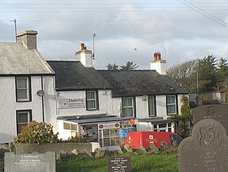
Gwyddelwern is a small village and community of 508 residents, reducing to 500 at the 2011 census, situated approximately 2 miles (3.2 km) north of Corwen in Denbighshire in Wales. Historically the village was part of the Edeyrnion district of Meirionnydd. Edeyrnion was part of the Glyndŵr district of Clwyd from 1974 to 1996, when the area became part of the principal area of Denbighshire. The village straddles the A494 road.

Chinley is a rural village in the High Peak Borough of Derbyshire, England, with a population of 2,796 at the 2011 Census. Most of the civil parish is within the Peak District National Park. Historically, before the coming of the railway, the area was economically dominated by agriculture. Nowadays most inhabitants commute out of the village to work; accessible centres of work include Stockport, Sheffield and Manchester.

Aberffraw is a village and community on the south west coast of the Isle of Anglesey in Wales. The village is 9 miles from the island's county town, Llangefni, and is located on the west bank of the Afon Ffraw. The community includes Soar and Dothan. Located near the A4080 and the nearest rail station is Bodorgan.

Karol Bagh is a neighborhood in Central District of Delhi, India. It is a mixed residential and commercial neighborhood known for shopping streets, such as the Ghaffar Market and Ajmal Khan Road.

Marsden is located on the outskirts of the seaside town South Shields, North East England, located on the North Sea coast. It lies within historic County Durham.

Patrington is a large village and civil parish in the East Riding of Yorkshire, England, in an area known as Holderness, 9 miles (14 km) south-east of Hedon, 16 miles (26 km) south-east of Kingston upon Hull and 4 miles (6.4 km) south-west of Withernsea on the A1033. Along with Winestead, it was a seat of the ancient Hildyard/Hilliard/Hildegardis family.
Swansea city centre in Swansea, Wales, contains the main shopping, leisure and nightlife district in Swansea. The city centre covers much of the Castle ward including the area around Oxford Street, Castle Square, and the Quadrant Shopping Centre; Alexandra Road, High Street, Wind Street and the Castle; Parc Tawe; and the Maritime Quarter extending down to the seafront.

Gwalchmai is a village on Anglesey in north Wales, within the Trewalchmai community.

Malltraeth is a small village in the southwest of Anglesey, in the community of Bodorgan. It is now at the end of a large bay, which used to extend much further inland, almost creating a second sea strait in the area. The population as of the 2011 census was only 255.

Bodorgan is a village and community on the Isle of Anglesey, Wales, United Kingdom. According to the 2001 Census, there were 1,503 residents in the now former electoral ward, 72.7% of them being able to speak Welsh. This increased to 1,704 at the 2011 Census but only 67.72% of this increased population were Welsh speakers.
Church Village is a large village in the historic parish and community of Llantwit Fardre, located within the Taff Ely district of the County Borough of Rhondda Cynon Taf in Wales. The village is centrally located being around 4 miles (6.4 km) from the local principal towns of Llantrisant to the southwest and Pontypridd to the north and is situated approximately 8 miles northwest of Cardiff city centre.

Llanrug is a medium-sized village and community in Gwynedd, north-west Wales. It lies about 4 miles (6.4 km) to the east of Caernarfon, 7 miles (11 km) south of Bangor and 3 miles (4.8 km) northwest of Llanberis. It is the largest populated village in the Arfon area of Gwynedd, Wales. The old name of the village was Llanfihangel-yn-y-grug, derived from Eglwys Sant Mihangel, which is situated about half a mile west of the village.
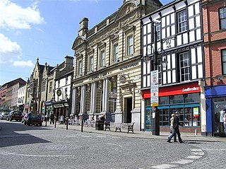
Wrexham city centre is the administrative, cultural and historic city centre of Wrexham, in North Wales and is the area enclosed by the inner ring road of the city. It is the largest shopping area in north and mid Wales, and the administrative centre of Wrexham County Borough. Many of its streets are pedestrianised.

Efail Isaf is a village located to the south of Llantwit Fardre in south Wales. It is located in the County Borough of Rhondda Cynon Taf. The former Barry Railway ran nearby. Efail Isaf has a village hall

Llanfairpwllgwyngyll or Llanfair Pwllgwyngyll, often shortened to Llanfairpwll and sometimes to Llanfair PG, is a village and community on the Isle of Anglesey, Wales. It is located on the Menai Strait, next to the Britannia Bridge. At the 2011 Census the population was 3,107, of whom 71% could speak Welsh. In 2021, the population decreased to 2,900. It is the sixth largest settlement in the county by population.

Llanyblodwel is a village and civil parish in Shropshire, England; the spelling "Llanyblodwell" was commonly used in the past, and the village was sometimes simply referred to as "Blodwel". The population of the civil parish at the 2011 census was 767. It lies 7 miles west of the nearest town, Oswestry, in the valley of the River Tanat. Simon Jenkins, in his guide to English churches says of Llanyblodwel that "the Welsh Marches are seldom so lovely as where the River Tanat crosses the border through the steep wooded valleys west of Oswestry."
Llanfaelog is a village and community in western Anglesey, Wales. It is situated some 13 kilometres south-east of Holyhead and 22 kilometres west of the city of Bangor. At the 2001 census, it had a population of 1,679, increasing to 1,758 at the 2011 Census. The community includes Rhosneigr, Bryn Du, and Pencarnisiog. The population of the village itself is less than 400.