The East Riding of Yorkshire, often abbreviated to the East Riding or East Yorkshire, is a ceremonial county in the Yorkshire and the Humber region of England. It borders North Yorkshire to the north and west, South Yorkshire to the south-west, and Lincolnshire to the south across the Humber Estuary. The city of Kingston upon Hull is the largest settlement.

The County of Brant is a single-tier municipality in the Canadian province of Ontario. Although it retains the word "county" in its name, the municipality is a single-tier municipal government and has no upper tier. The County of Brant has service offices in Burford, Paris, Oakland, Onondaga and St. George. The largest population centre is Paris.

Dundas is an urban district and former town in Hamilton, Ontario, Canada. It is nicknamed the Valley Town because of its topographical location at the bottom of the Niagara Escarpment on the western edge of Lake Ontario. The population has been stable for decades at about 20,000, largely because it has not annexed rural land from the protected Dundas Valley Conservation Area.

Mount Forest is an unincorporated community located at the junction of Highway 6 and Highway 89 in the township of Wellington North, Ontario, Canada. As of the 2011 Canadian census the population of Mount Forest was 4,757.

Ancaster—Dundas—Flamborough—Westdale was a federal electoral district in Ontario, Canada, that has been represented in the House of Commons of Canada from 2004 until the electoral boundaries were redrawn for the 2015 election.

Flamborough is a district and former municipality in the city of Hamilton, Ontario, Canada. For most of its existence before amalgamation with Hamilton in 2001, Flamborough comprised the former townships of East Flamborough, West Flamborough, and Beverly, as well as the village of Waterdown. The largest suburban community is the former village of Waterdown containing perhaps one third of its thirty thousand or so inhabitants. Other Flamborough communities include Carlisle, Christie's Corners, Clappison's Corners, Copetown, Freelton, Greensville, Lynden, Kirkwall, Millgrove, Mountsberg, Orkney, Peters Corners, Rockton, Troy, Sheffield, Valens, Strabane and Westover.
Wentworth County, area 269,057 acres (1,089 km2), is a historic county in the Canadian province of Ontario.
Halton County is a former county in the Canadian province of Ontario, with an area of 92,342 hectares. It is also one of the oldest counties in Canada.

Waterdown is a village in Canada which since 2001 has been a community of Hamilton, Ontario. Waterdown is approximately 60 km west of downtown Toronto. Waterdown, as of 2021, has a population of approximately 24,400 residents.

Glanbrook is the south-western district of the city of Hamilton, Ontario, Canada. It was first created as an independent township in 1974 through the amalgamation of Mount Hope, Binbrook, Glanford, and other nearby communities. In 2001, Glanbrook became a dissolved municipality after it was amalgamated with Hamilton, Stoney Creek, Dundas, Ancaster and Flamborough to become the present city of Hamilton.

Hamilton Mountain is a federal electoral district in Ontario, Canada, that has been represented in the House of Commons of Canada since 1968. The riding is located in the Hamilton region.

Westdale is a residential neighbourhood in Hamilton, Ontario, Canada. It is centred in the Westdale Village shopping district and located near McMaster University. It is bordered to the north by Cootes Paradise, an extensive nature reserve marking the western end of Lake Ontario, to the south by Main Street and Ainslie Wood, to the east by Highway 403, and to the west by McMaster University.
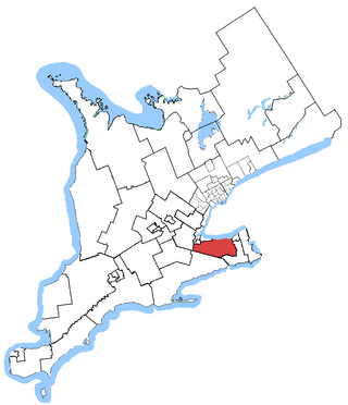
Niagara West—Glanbrook was a federal electoral district in Ontario, Canada, that existed from 2004 to 2015.
Wentworth North was a federal electoral district represented in the House of Commons of Canada from 1867 to 1896. It was located near the city of Hamilton in the province of Ontario. It was created by the British North America Act of 1867. The "North Riding of Wentworth" consisted of the Townships of Beverley, Flamborough East and Flamborough West, and the Town of Dundas.
Millgrove is a small rural community in Ontario, Canada.

Lynden is a community within Flamborough, which is itself part of the city of Hamilton, Ontario, Canada.

Roseville is a community in Ontario, Canada located at 43°20′35″N80°28′31″W. It is within the rural township of North Dumfries, which forms part of the Region of Waterloo, and is located between Ayr, Kitchener and Highway 401.

Brantford—Brant is a provincial electoral district in southwestern, Ontario, Canada. The district elects one member to the Legislative Assembly of Ontario. It was created in 1999 from all of Brantford and part of Brant—Haldimand. When the riding was created, it included the city of Brantford, the town of Paris plus the townships of Brantford and South Dumfries.
Flamboro Downs is a half-mile harness horse racing track in Flamborough, Hamilton, Ontario, Canada. It is also home to Flamboro Slots, which has a total of 808 slot machines.

Augustus Jones was a North American-born Upper Canadian farmer, land speculator, magistrate, militia captain and surveyor. Jones trained as a surveyor in New York City, and fled as a United Empire Loyalist to Upper Canada. In Upper Canada, he worked as a crown surveyor in the Nassau District, where he quickly rose to the position of Deputy Surveyor General, the highest position in a district of Upper Canada. He occupied that position from 1789 informally, and 1791 formally, until his retirement in 1799. During that time he laid down many of the township boundaries in the Niagara Peninsula and on the north shore of Lake Ontario. He led various teams that cut many of the first sideroads and concession roads into these areas, facilitating their settlement by European and American immigrants. Jones also surveyed the routes for Dundas Street and Yonge Street, and supervised their construction. After his retirement, Jones farmed first in Saltfleet Township, later moving to Brantford and finally an estate outside Paris named Cold Springs, where he died in 1836.
