
Denver is a village and civil parish in the English county of Norfolk. The village is situated on the River Great Ouse, approximately 1 mile (2 km) south of the small town of Downham Market, 14 miles (22 km) south of the larger town of King's Lynn, and 37 miles (60 km) west of the city of Norwich.

Aveley is a town and former civil parish in the unitary authority of Thurrock in Essex, England, and forms one of the traditional Church of England parishes. Aveley is 16 miles (26.2 km) east of Charing Cross. In the 2021 United Kingdom census it had a population of 9,801. In 1931 the parish had a population of 2,003.
Great Ryburgh is a village and former civil parish, now in the parish of Ryburgh, in the North Norfolk district, in the county of Norfolk, England. In 1961 the parish had a population of 484. On 1 April 1987 the parish was abolished and merged with Little Ryburgh to form "Ryburgh".

Bolam is a village and former civil parish, now in the parish of Belsay in the county of Northumberland, England. The village is about 20 miles (32 km) north-west of Newcastle upon Tyne, near Bolam West Houses. In 1951 the civil parish had a population of 60. On 1 April 1955 it was merged into Belsay.

Ashby St Mary, historically Ascebei, is a small village and civil parish in the English county of Norfolk. The civil parish has an area of 2.03 square kilometres (0.78 sq mi) and in the 2001 census had a population of 297 in 115 households, the population increasing to 316 in 120 households at the 2011 Census. For the purposes of local government, the parish falls within the district of South Norfolk.

Bessingham is a village and former civil parish, now in the parish of Sustead, in the North Norfolk district of the English county of Norfolk. It lies 8 mi (13 km) north-north-west of Aylsham and 5 mi (8.0 km) south-south-west of Cromer. In 1931 the parish had a population of 122. On 1 April 1935 the parish was abolished and merged with Sustead.
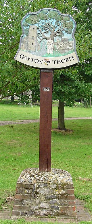
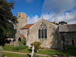
Gayton Thorpe is a village and former civil parish, now in the parish of Gayton, in the King's Lynn and West Norfolk district, in the county of Norfolk, England. In 1931 the parish had a population of 136.

East Lexham is a village and former civil parish, now in the parish of Lexham, in the Breckland district, in the English county of Norfolk. It is 7.7 miles (12.4 km) north of the town of Swaffham, 30.1 miles (48.4 km) west north west of Norwich and 106 miles (171 km) north east of London. In 1931 the parish had a population of 160.

Worthing is a small village and former civil parish in the Breckland district, in the county of Norfolk, England. The civil parish of Worthing is now merged with that of the neighbouring village of Hoe, though the ecclesiastical parishes are still separate. In 1931 the parish had a population of 120. On 1 April 1935 Worthing was abolished and merged with Hoe, the renamed parish is now called Hoe and Worthing.

Brome is a village and former civil parish in the north of the English county of Suffolk. It lies on the A140 Norwich to Ipswich road around 1 mile (1.6 km) northwest of Eye and 2 miles (3.2 km) southeast of Diss near the border with Norfolk. In 1961 the parish had a population of 230. The village is now in the parish of Brome and Oakley and has been combined with the village of Oakley for centuries but the civil parish was only combined in 1982.

Burston is a village and former civil parish, now in the parish of Burston and Shimpling, in the South Norfolk district, in the county of Norfolk, England, 3 miles (4.5 km) north of Diss. In 1931 the parish had a population of 279. In the 2011 Census, Burston and Shimpling had a population of 568 people in 234 households.

Babingley is a village and former civil parish, now in the parish of Sandringham, in the King's Lynn and West Norfolk district, in the county of Norfolk, England, about 1 mile (1.6 km) northwest of Castle Rising and 5+1⁄2 miles (9 km) north-north-east of King's Lynn. In 1931 the parish had a population of 91. On 1 April 1935 the parish was abolished and merged with Sandringham.

Fordham is a small village and civil parish in the English county of Norfolk. The village is located 2.2 miles (3.5 km) north of Downham Market and 39 miles (63 km) west of Norwich, located along the A10 between London and King's Lynn and close to the confluence of the River Wissey and River Great Ouse.

East Raynham is a village and former civil parish, now in the parish of Raynham, in the North Norfolk district, in the county of Norfolk, England. It is located on the A1065 some 4 miles (6.4 km) south-west of Fakenham. The River Wensum flows close to the village. The village can trace its origins back and before the Domesday survey of 1086 when it was known as Reinham. Raynham, Massachusetts took the village's name at its incorporation in 1731 at the time of Charles Townshend, 2nd Viscount Townshend (1674–1738), Leader of the House of Lords. In 1931 the parish had a population of 130.

East Barsham is a village and former civil parish, now in the parish of Barsham, in the North Norfolk district, in the English county of Norfolk. In 1931 the parish had a population of 144. On 1 April 1935 the parish was abolished to form Barsham.
Tibenham is a village and civil parish located in the Depwade district of South Norfolk, England. The parish is 2 miles (3.2 km) north west of Tivetshall railway station. It has a public house called The Greyhound.
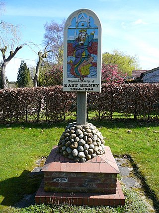
East Bilney is a village and former civil parish, now in the parish of Beetley, in the Breckland district, in the county of Norfolk, England. East Bilney is located 7.8 kilometres (4.8 mi) north-west of Dereham and 30 kilometres (19 mi) north-west of Norwich. In 1931, the parish had a population of 117.
Thrigby is a village and former civil parish 14 miles (23 km) east of Norwich, now in the parish of Mautby, in the Great Yarmouth district, in the county of Norfolk, England. In 1931 the parish had a population of 47.

Shimpling is a village and former civil parish 16 miles (26 km) south of Norwich, now in the parish of Burston and Shimpling, in the South Norfolk district, in the county of Norfolk, England. In 1931 the parish had a population of 134.

Carleton Forehoe is a village and former civil parish 9 miles (14 km) west of Norwich, now in the parish of Kimberley, in the South Norfolk district, in the county of Norfolk, England. In 1931 the parish had a population of 123.


