Amravati is the second largest city in the Vidarbha region and ninth largest city in Maharashtra, India. It is administrative headquarters of Amravati district and Amravati division which includes Akola, Buldhana, Washim, and Yavatmal districts. It is one of the Maharashtra's nominated city under Smart Cities Mission.

Yavatmal districtpronunciation (help·info), [jəʋət̪maːɭ] formerly known as Yeotmal, is a district of the Indian state of Maharashtra. It is located in the region of Vidarbha, in the east-central part of the state. It is Vidarbha's third-largest district by population, after Nagpur and Amravati. Yavatmal city is the administrative headquarters of the district.

Vrindavan, also spelt Vrindaban and Brindaban, is a historical city in the Mathura district of Uttar Pradesh, India. It is located in the Braj Bhoomi region and holds religious importance in Hinduism as Krishna spent most of his childhood days in this city. Vrindavan has about 5,500 temples dedicated to the worship of Krishna and his divine consort Radha.

Osmanabad District is an administrative district in the Marathwada region in the Indian state of Maharashtra. The district headquarter is located at Osmanabad. The District of Osmanabad derives its name from the last ruler of Hyderabad, the 7th Nizam, Mir Osman Ali Khan, of which the region was a part till 1947. This region was earlier part of The Hyderabad State until Independence.This primarily rural district occupies an area of 7,569 km2 (2,922 sq mi) of which 241.4 km2 (93.2 sq mi) is urban and has a population of 1,657,576 of which 16.96% were urban.
Amravati district is a district of Maharashtra state in central India. It is the administrative headquarter of Amravati division, which is one of the two divisions in Vidarbha, out of total 6 regions in state of Maharashtra.
Murtijapur is a Municipal council and one of the taluka of district of Akola of Amravati division of Vidarbha region of Maharashtra.

Shivpuri District is a district of Madhya Pradesh state of India. The town of Shivpuri is the district headquarters. National Highway 3 (NH-3) runs through the district.
Anjangaon is a city and a municipal council in Amravati district in the state of Maharashtra, India. Anjangaon City got the status of Municipal Council in 1930. It is the first municipal council established in Amravati district and the second biggest council as well. Anjangaon Surji Tehsil was established in 1981. It is technically made up of two main zones, Anjangaon and Surji, on either side of Shahanur River, and is called Anjangaon-Surji in combination. It is called a "Banana Hub of Vidarbha" as it is a large producer of bananas and a hub of medicinal plants - Piper longum and Safed musali.

Bhainsa is a town in Nirmal district of the Indian state of Telangana. It is the headquarters of Bhainsa mandal and Bhainsa revenue division. It is bordered with Bhokar Thaluka, Nanded Jilla, Maharashtra State on west and Nizamabad district on South. Bhainsa is located at 19.1000°N 77.9667°E. It has an average elevation of 363 meters (1194 feet).
Chikhli is a city and a municipal council in Buldana district in Vidarbha Region of Maharashtra state, India. It is located on the Pune-Nagpur highway. It is situated at the westernmost border of Vidarbha region of Maharashtra and is 500 km from the state capital, Mumbai. Chikhli has the largest population in buldhana district and is the biggest taluka. Chikhli is situated on the border of the Marathwada Region and Vidarbha Regions of Maharashtra. Chikhli is the nearest municipal council to the district place, Buldana, approximately 25 km only. Also in addition, there is a cotton factory in Chikhli which provides employment to many people who comes in this city for employment purpose. MIDC is located on Nagpur-Pune highway where many small scale, middle scale and some large scale firms of automotive, chemical, fibres and plastic, iron casting and other sectors are situated. Textile park was sanctioned near city and land acquisition and other government processes are going on regarding this.
Daryapur is a city located in the Amravati District of Maharashtra State, India. It belongs to the Vidarbha region of the Amravati Division. It is located 52 km (32.31m) west of the District headquarters of Amravati.
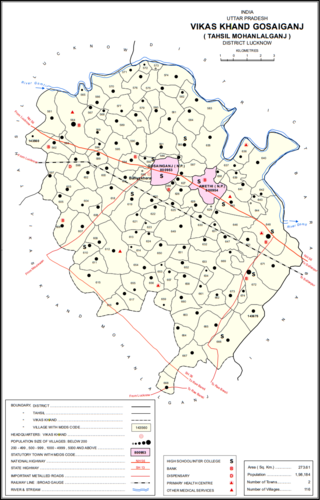
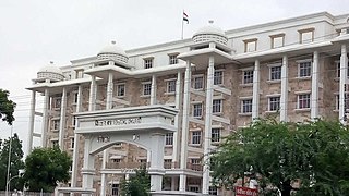
Gosainganj, also spelled Goshainganj or Gosaiganj is a town and nagar panchayat in Lucknow district of Uttar Pradesh, India. It is the seat of a community development block, which is included in the tehsil of Mohanlalganj. As of 2011, its population is 9,649, in 1,685 households. The starting point of the Purvanchal Expressway i.e. Chand Saray village is situated 2.5 km away from Gosainganj.
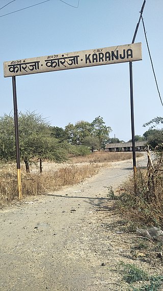
Karanja Lad is a city of a Municipal council in Washim district in the Indian state of Maharashtra. Karanja is also known as Karanja Lad. The town is named after Saint Karanj. It is often also referred as "Lad'anche Karanja" in honor of Muslim Queen(ra). Karanja is a holy place for Hindus, Jains, and Muslims. It is the birthplace of Shri Narasimha Saraswati Swami Maharaj, believed to be the second incarnation of Lord Dattatreya..
Multai is a town and a Nagar Palika in Betul district in the Indian state of Madhya Pradesh. Multai is one of the southern cities of Madhya Pradesh, occupying almost half of the Satpura plateau. Considering the small villages around, it occupies a large area in width of the Satpura range between the valley of the Narmada on the north and the barer plains on the south. Forests lie to the west of the city between the districts of East Nimar and Amaraoti. It lies on the Northern bank of the Tapti and the place is also known for being the origin of the Tapti river.
Warud is also known as Orange City and a municipal council in Amravati district in the Indian state of Maharashtra

Bhadravati is a city and a municipal council in Chandrapur district in the state of Maharashtra, India. It lies 26 km from Chandrapur city. Bhadravati city has recently bagged the Best City in 'Innovation & Best Practices' award under the population Category - 50K to 1 Lakh from the Government of India under Swach Surverkshan Awards-2021. It has also bagged 8th Rank in being the cleanest city under category population Category - 50K to 1 Lakh under Swach Surverkshan Awards-2021 amongst 132 cities nominated.
Tiosa, or Tivsa, is a town, municipal council, and tehsil in Amravati district in the state of Maharashtra, India.

Nandgaon Khandeshwar is a city and a municipal council in Amravati district in the state of Maharashtra, India. Nandgaon Khandeshwar is one of the three townships (talukas) in Chandur (Railway) subdivision in Amravati district. The other two are Dhamangaon Railway and Chandur Railway. Khandeshwar Temple is the most famous and oldest place in Nandgaon Khandeshwar and was built by Hemadpantis. In Maha Shivaratri, there is a fair at Khandeshwar Temple, which is a big event for the people of Nandgaon Khandeshwar. This event is celebrated for 7 days by all of Nandgaon. This is one of the municipalities of Amravati district. It has good connectivity by road and is near Samruddhi Highway and Navnagar.
Deori, Sagar is a historical city situated on the banks of river " Aas " Sukhchain, on the Narsinghpur-Sagar city road. Deori kalan is a 150 year old municipality under Sagar district in the state of Madhya Pradesh, India.
BajrangarhFort is located in Bajrangarh village of Guna District in the Indian state of Madhya Pradesh. It was built by the Yadav (Ahir) King Jai Narayan of Nandvanshi Branch in 1600 AD. The Bajrangarh fort lies at an altitude of around 92.3 metres (303 ft) and is in ruins.fort is about 10 kilometres from Guna on Guna to Aron road on the bank of Chapet river around 8 kilometres south-west of Guna city. It spreads over 72 bighas of land on a high hill. ,it was the headquarters of a mahal of the Chanderi Sarkar. During the reign of Raja Jai Singh, Daulatrao Scindia sent his General, John Baptiste to attack the fort in 1816 A.D. Raja Jai Singh was defeated and the fort was destroyed. The Bajrangarh fort had four gates in four directions. Inside the fort, Moti Mahal, Rangmahal, Ram Mandir, and Bajrang Mandir are still intact.