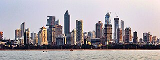
Mumbai is the capital city of the Indian state of Maharashtra. Mumbai is the financial capital and the most populous city of India with an estimated population of 12.5 million (1.25 crore). Mumbai is the centre of the Mumbai Metropolitan Region, the sixth-most populous metropolitan area in the world with a population of over 23 million living within the Mumbai Metropolitan Region. Mumbai lies on the Konkan coast on the west coast of India and has a deep natural harbour. In 2008, Mumbai was named an alpha world city. Mumbai has the highest number of billionaires out of any city in India as well as in Asia.
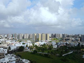
Surat is a city in the western Indian state of Gujarat. The word Surat literally means face in Urdu, Gujarati and Hindi. Located on the banks of the river Tapti near its confluence with the Arabian Sea, it used to be a large seaport. It is now the commercial and economic centre of South Gujarat, and one of the largest urban areas of western India. It has well-established diamond and textile industry, and is a major supply centre for apparels and accessories. About 90% of the world's diamonds are cut and polished in Surat. It is the second largest city in Gujarat after Ahmedabad and the eighth largest city by population and ninth largest urban agglomeration in India. It is the administrative capital of the Surat district.

Thane district is a district in the Konkan Division of Maharashtra, India. At the 2011 Census it was the most populated district in the country, with 11,060,148 inhabitants; however, in August 2014 the district was split into two with the creation of a new Palghar district, leaving the reduced Thane district with a 2011 Census population of 11,060,148. The headquarters of the district is the city of Thane. Other major cities in the district are Navi Mumbai, Kalyan-Dombivli, Mira-Bhayander, Bhiwandi, Ulhasnagar, Ambarnath, Badlapur, Murbad and Shahapur.

The Mumbai Metro is a rapid transit (MRT) system serving the city of Mumbai and the wider Mumbai Metropolitan Region in Maharashtra, India.

Navi Mumbai is a planned city next to Mumbai (Bombay), located in the Konkan division of the western Indian state of Maharashtra, on the mainland of India. Navi Mumbai is situated across two districts, Thane (Taana) & Raigad. It is a part of the Mumbai Metropolitan Area.
Palghar is a town in the Konkan division of Maharashtra state, India and a municipal council. It is in the Mumbai Metropolitan Region, and since 2014 it has been the administrative capital of the Palghar district. Palghar lies on the Western Line of the Mumbai Suburban Railway in the busy Mumbai-Ahmedabad rail corridor. The town is located about 87 kilometers north of Mumbai, about 35 kilometers north of Virar and about 24 kilometers west of the Mumbai-Ahmedabad National Highway at Manor.
Valsad, historically known as Bulsar, is a city and a municipality in Valsad district of the Indian state of Gujarat. It is the district headquarters of Valsad district. Valsad is located south of Navsari and shares border with Maharashtra and the union territories of Dadra and Nagar Haveli and Daman and Diu in the south.

Vapi, is a city and Municipal Corporation in Valsad district in the state of Gujarat, India. It is situated near the banks of the Daman Ganga River, around 28 km south of the district headquarters in the city of Valsad, and it is surrounded by the Union Territory of Dadra and Nagar Haveli and Daman and Diu. It is believed that the city got its name from the old small stepwell situated near the Balitha area. The meaning of vapi (वापी) in sanskrit is a water reservoir or a water storage body.

Mumbai Metropolitan Region, is a metropolitan area consisting of Mumbai and its satellite towns in the northern Konkan division of Maharashtra in western India. The region has an area of 6,328 square kilometres (2,443 sq mi) and with a population of over 26 million it is among the most populous metropolitan areas in the world.

Jawaharlal Nehru Port, also known as JNPT and Nhava Sheva Port, is the second largest container port in India after Mundra Port. Operated by the Jawaharlal Nehru Port Trust Authority (JNPTA), it is located on the eastern shores of Arabian Sea in Navi Mumbai, Raigad district, Maharashtra. This port can be accessed via Thane Creek, a nodal city of Navi Mumbai. It is the main port of the Mumbai Metropolitan Region after Mumbai Port, also of Maharashtra and Western India. Its common name derives from the names of Nhava and Sheva villages that are situated here. It is also the terminal of the Western Dedicated Freight Corridor.

Kolkata is the prime business, commercial and financial hub of eastern India and the main hub of communication for the North East Indian states. Kolkata is the third largest city by GDP in India after Mumbai and Delhi, with a GDP of $160 billion (PPP). Kolkata is home to India's oldest, stock exchange company (bourse) – The Calcutta Stock Exchange. Kolkata is home to many industrial units operated by large public- and private-sector corporations; major sectors include Steel, Heavy engineering, Mining, Minerals, cement, pharmaceuticals, Food processing, Agriculture, electronics, textiles, and jute.
The economy of the state of Maharashtra is the largest in India. Mumbai, the capital of Maharashtra and often described as the New York of India or Manhattan of India, is the financial capital and the most populous city of India with an estimated city proper population of 12.5 million (1.25 crore). The city is the entertainment, fashion, and commercial centre of India. Mumbai hosts the largest urban economy of any city in India. is considered the financial capital of India with the headquarters of almost all major banks, financial institutions, insurance companies and mutual funds being based in the city. India's largest stock exchange Bombay Stock Exchange, the oldest in Asia, is also located in the city. More than 41% of the S&P CNX 500 conglomerates have corporate offices in Maharashtra.

The economy of Gujarat, a state in Western India, is the most industrialised in India, having the highest industrial output of any state in the union.It has the highest exports of any Indian state, accounting for 33% of all Indian exports in 2022-23. It leads in diverse industrial sectors such as chemicals, petrochemicals, dairy, drugs and pharmaceuticals, cement and ceramics, gems and jewellery, textiles and engineering. It has the highest Electricity Production Capacity and Maritime Port Cargo Volume among all states in India. It also has significant agricultural production with major agricultural produce of the state being cotton, groundnuts (peanuts), dates, sugar cane, milk and milk products. Gujarat recorded the lowest unemployment rate in India in 2022, with 4.4% of the labour force being unemployed.

Vasai-Virar is an agglomeration of four previously governed municipal councils: Vasai (Bassein), Virar, Nallasopara and Navghar-Manikpur, as well as a few towns to the east and west of the urban area. It lies in the Konkan division of Maharashtra, India.

Allcargo Logistics Limited is a Mumbai-based Indian logistics company. It is known to offer multi-modal integrated logistics and transportation services worldwide.
Boisar is the largest industrial suburb in the Mumbai Metropolitan Region in the Indian state of Maharashtra. It was originally a part of the Thane district before becoming a part of the Palghar district. It is approximately 111 kilometers away from the state capital Mumbai, and is 98 km (61 mi) from the union territory Daman. It is located in the district Palghar in Maharashtra.
Bhadane is a village in the Thane district of Maharashtra, India. It is located in the Bhiwandi Taluka.

Line 5 (Orange Line) of the Mumbai Metro is a rapid transit metro line in the city of Mumbai, Maharashtra, India. When completed, the 24.9 km (15.5 mi) line will connect Thane with Kalyan via Bhiwandi, with 17 stations. The line will be fully elevated except for a 3 km underground section in Bhiwandi.
Thane high-speed railway station is an under-construction high-speed railway station on the Mumbai–Ahmedabad high-speed rail corridor. This station is located near Datiwali in Diva Gaon, Thane district, Maharashtra, India. It is the second station of the Mumbai–Ahmedabad high-speed rail corridor, after Mumbai BKC station and before Virar station. The station will have the first depot of the high-speed rail corridor, just north of it near Bhiwandi.

