
Andhra Pradesh is a state in the south-eastern coastal region of India. It is the seventh-largest state by area covering an area of 162,975 km2 (62,925 sq mi) and tenth-most populous state with 49,386,799 inhabitants. It is bordered by Telangana to the north-west, Chhattisgarh to the north, Odisha to the north-east, Tamil Nadu to the south, Karnataka to the west and the Bay of Bengal to the east. It has the second longest coastline in India after Gujarat, of about 974 km (605 mi). Andhra Pradesh was the first state to be formed on a linguistic basis in India on 1 October 1953. On 1 November 1956, Andhra State was merged with the Telugu-speaking areas of the Hyderabad State to form Andhra Pradesh. Amaravati serves as the capital with the largest city being Visakhapatnam.

A postal code is a series of letters or digits or both, sometimes including spaces or punctuation, included in a postal address for the purpose of sorting mail.

Srikakulam is a city and the headquarters of Srikakulam district in the Indian state of Andhra Pradesh. As of 2011 census,. it has a population of 165,735. There are many other places of Buddhist Tourism such as Salihundam, Calinga Patnam, Dabbaka Vaani Peta, Nagari Peta, Jagati Metta, Singupuram etc. in Srikakulam District. The Buddhist heritage site of Salihundam has some unique features. It has a beautiful star atop a stupa, rock cut massive stupaas inside chaitya grihas, brick stupas with wheel pattern plan, votive stupas, inscriptions on the steps leading to the stupas and museum housing over two dozen sculpted statue and figurines of Buddha, Jain Teerthankars and other deities
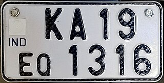
All motorised road vehicles in India are tagged with a registration or licence number. The Vehicle registration plate number is issued by the district-level Regional Transport Office (RTO) of respective states — the main authority on road matters. The number plates are placed in the front and back of the vehicle. By law, all plates are required to be in modern Hindu-Arabic numerals with Latin letters. The international vehicle registration code for India is IND.
In India, mobile numbers on GSM, WCDMA, and LTE networks start with either 9, 8, 7 or 6. Each telecom circle is allowed to have multiple private operators; earlier it was two private + BSNL/MTNL, subsequently it changed to three private + BSNL/MTNL in GSM; now each telecom circle has all four operators including Reliance Jio, Bharti Airtel, Vodafone idea ltd and BSNL/MTNL.

Vizianagaram district is one of the six districts in the Uttarandhra region of the Indian state of Andhra Pradesh with its headquarters located at Vizianagaram. The district is bounded on the east by the district of Srikakulam, north by Parvathipuram Manyam southeast by Visakhapatnam, south by Anakapalli, southeast by the Bay of Bengal, and northwest by the state of Odisha. It was formed on 1 June 1979, with some parts carved from the neighbouring districts of Srikakulam and Visakhapatnam. The district is named after the princely state of Vizianagaram. It is the least populous district in Andhra Pradesh.

Srikakulam district is one of the twenty-six districts of the Indian state of Andhra Pradesh, located in the Uttarandhra region of the state, with its headquarters located at Srikakulam. It is one of the six districts, located in the extreme northeastern direction of the state. It was formerly known as Chicacole.

Bobbili is a town in Vizianagaram district of the Indian state of Andhra Pradesh.

Palakollu is a city and the administrative headquarters of Palakollu Mandal in Narasapuram revenue division in West Godavari district of the Indian state of Andhra Pradesh. Palakollu is situated in Coastal Andhra region of the state. It occupies 4.685 square kilometres (1.809 sq mi). As of 2011 census, it has a population of about 61,284 and a Metro population of about 81,199. Palakollu Municipality merged five Grama panchayats of Seven village's on dated 7 January 2020. the Seven Village's population of 42,932 It around occupies 20.08 square kilometres (7.75 sq mi) and after merged palakollu municipality It around occupies 24.68 square kilometres (9.53 sq mi) with 35 election wards it is total population of 1,04,216 and making it the fourth most populous urban area in West Godavari District in Andhra Pradesh. It is a part of Eluru Urban Development Authority.
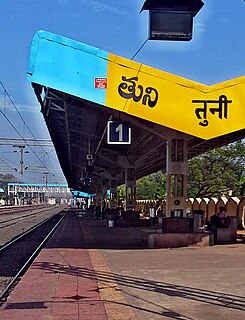
Tuni is a city in Kakinada district of the Indian state of Andhra Pradesh. It is a second biggest city in kakinada district. And it is the fastest growing city in Andhra Pradesh. It is a major commercial marketing center for more than 100 surrounding villages in the district. Tuni is a border point for the district of Kakinada. It is known for mango production, with nearly 250 varieties being exported from the area. Tuni is also famous for the production of betel leaves and jute bags. A variety of cashew nuts are also produced in Tuni.

Andhra Pradesh State Road Transport Corporation (APSRTC) is the state-owned road transport corporation in the Indian state of Andhra Pradesh. Its headquarters is located at NTR Administrative Block of RTC House in Pandit Nehru bus station of Vijayawada. Many other Indian metro towns in Telangana, Tamil Nadu, Karnataka, Odisha, Yanam, Kerala, Maharashtra and Chhattisgarh are also linked with the APSRTC services.
Telephone numbers in India are administered under the National Numbering Plan of 2003 by the Department of Telecommunications of the Government of India. The numbering plan was last updated in 2015. The country code "91" was assigned to India by the International Telecommunication Union in the 1960s.

Aadhaar is a 12-digit unique identity number that can be obtained voluntarily by the citizens of India and resident foreign nationals who have spent over 182 days in twelve months immediately preceding the date of application for enrolment, based on their biometric and demographic data. The data is collected by the Unique Identification Authority of India (UIDAI), a statutory authority established in January 2009 by the Government of India, under the jurisdiction of the Ministry of Electronics and Information Technology, following the provisions of the Aadhaar Act, 2016.

MeeSeva is a good governance initiative that incorporates the vision of National eGov Plan "Public Services Closer to Home" and facilitates single entry portal for entire range of G2C and G2B services.

Digital India is a campaign launched by the Government of India in order to ensure the Government's services are made available to citizens electronically by improved online infrastructure and by increasing Internet connectivity or making the country digitally empowered in the field of technology. The initiative includes plans to connect rural areas with high-speed internet networks. It consists of three core components: the development of secure and stable digital infrastructure, delivering government services digitally, and universal digital literacy.

Amaravati is the capital of the Indian state of Andhra Pradesh. It is located on the banks of river Krishna in Guntur district.

J. Satyanarayana is a retired 1977 batch Indian Administrative Service officer of Andhra Pradesh cadre. Satyanarayana is the current Chairman of Unique Identification Authority of India (UIDAI), the nodal agency of Government of India for implementing Aadhaar. He also served as the Communications and Information Technology Secretary of India.
Mee-Bhoomi is a land records portal started by the Revenue Department of Andhra Pradesh. It allows visitors to find information on land, including ownership details. The website is in Telugu language. The purpose of Mee-Bhoomi is that the people of Andhra Pradesh can easily see their land records. On this portal, one can view the Adangal, 1-B form records with the survey number, account number, Aadhaar number and the names of the applicants. This portal offers an online link between an Aadhaar number and land records.
Being described as the Aadhaar for land, Unique Land Parcel Identification Number (ULPIN) is a 14-digits alphanumeric unique ID for each and every land parcel in India. Ultimately ULPIN will be used as single source of truth for land records in near future as it is designed to uniquely identify every surveyed land parcel in india based on the Textual records of rights (RoR) along with its corresponding geo coordinates. This ULPIN project concept was taken from Bhudhaar project in Andhra Pradesh and announced in October 2020 with a plan to assign ULPIN to all land parcels in India by March 2022.