East Lothian is one of the 32 council areas of Scotland, as well as a historic county, registration county and lieutenancy area. The county was also known as Haddingtonshire.

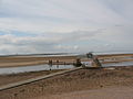
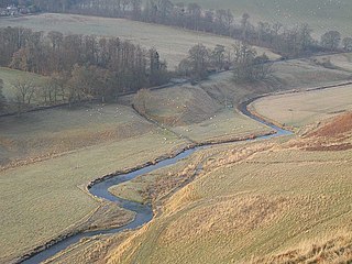
The River Tyne is a river in Scotland. It rises in the Moorfoot Hills in Midlothian near Tynehead to the south of Edinburgh, at the junction of the B6458 and the B6367. It continues approximately 30 miles northeast, and empties into the North Sea near Belhaven.

Dunbar is a town on the North Sea coast in East Lothian in the south-east of Scotland, approximately 30 miles east of Edinburgh and 30 mi (50 km) from the English border north of Berwick-upon-Tweed.
Lord Belhaven and Stenton, of the County of Haddington, is a Lordship of Parliament in the Peerage of Scotland. It was created in 1647 for Sir John Hamilton, 2nd Baronet, with remainder to his heirs male.

Mudflats or mud flats, also known as tidal flats, are coastal wetlands that form in intertidal areas where sediments have been deposited by tides or rivers. A recent global analysis suggested they are as extensive globally as mangroves. They are found in sheltered areas such as bays, bayous, lagoons, and estuaries; they are also seen in freshwater lakes and salty lakes alike, wherein many rivers and creeks end. Mudflats may be viewed geologically as exposed layers of bay mud, resulting from deposition of estuarine silts, clays and aquatic animal detritus. Most of the sediment within a mudflat is within the intertidal zone, and thus the flat is submerged and exposed approximately twice daily.
Aberlady Bay in East Lothian, Scotland lies between Aberlady and Gullane.

Belhaven is a village in East Lothian, Scotland, and was originally the ancient port of Dunbar of which town the village has always been a part. Belhaven takes its name from its situation at the mouth of the Biel Water. The village is home to Belhaven Hill School, an independent co-educational prep school for children between the ages of 7–13.

The South Calder Water, known locally as "The Cawder", or simply "Calder", is a river in Scotland. It runs west from the high plateau between Shotts and Fauldhouse to its joining with the much larger River Clyde.
Archerfield and Archerfield Links are a country house and pair of golf courses in the parish of Dirleton, East Lothian, Scotland. An older golf course, also called Archerfield Links, occupied the area before falling into disuse after World War II.
The Battle of Carham was fought between the Kingdom of Scotland and the Northumbrians at Carham on Tweed. Uhtred, son of Waltheof of Bamburgh, fought the combined forces of Malcolm II of Scotland and Owen the Bald. Their combined forces defeated Earl Uhtred's forces, determining the eastern border of Scotland at the River Tweed.

Stenton is a parish and village in East Lothian, Scotland. It is bounded on the north by parts of the parishes of Prestonkirk and Dunbar, on the east by Spott and on the west by Whittingehame. The name is said to be of Saxon derivation. The village has a number of houses, a school, and a church.
The Lyne Water is a tributary of the River Tweed which rises in the Pentland Hills of southern Scotland at Baddinsgill Reservoir. It runs through West Linton and Romannobridge, passes Flemington and Lyne Station and enters the Tweed west of Peebles. It floods regularly in winter and occasionally in summer. There is free fishing above Flemington Bridge, and below Flemington the river is part of the Peebles fishing authority.
Biel is a village in East Lothian, Scotland, UK, to the south of Dunbar, off the B6370 road. It is situated on the Biel Estate, close to Biel House.

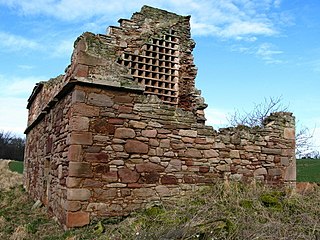
Preston Mill is a watermill on the River Tyne at the eastern edge of East Linton on the B1407 Preston Road, in East Lothian, Scotland, UK. It is situated close to Prestonkirk Parish Church, the Smeaton Hepburn Estate, Smeaton Lake, and Phantassie Doocot. It is a Category A listed building.
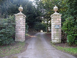
Biel House is a historic house on the Biel Estate near Stenton, East Lothian, Scotland. It is a Category A listed building.

The River Leader, or Leader Water, is a small tributary of the River Tweed in Lauderdale in the Scottish Borders. It flows southwards from the Lammermuir Hills through the towns of Lauder and Earlston, joining the River Tweed at Leaderfoot.

Pease Bay is a bay in the Scottish Borders area of Scotland, close to the border with East Lothian as well as Cockburnspath, Cove and Dunglass. The area is notable as a holiday destination, for surfing in Scotland, and also for the large static caravan park at the bottom of the bay.

Cranshaws is a village on the B6355 road, near Duns, in the Scottish Borders area of Scotland, in the former Berwickshire.

Dunbar Harbour is a seaport forming the north-east part of the town of Dunbar, East Lothian, Scotland. It is situated on a point projecting from the North Sea coast of East Lothian, into the mouth of the Firth of Forth.