The Alpine region of Switzerland, conventionally referred to as the Swiss Alps, represents a major natural feature of the country and is, along with the Swiss Plateau and the Swiss portion of the Jura Mountains, one of its three main physiographic regions. The Swiss Alps extend over both the Western Alps and the Eastern Alps, encompassing an area sometimes called Central Alps. While the northern ranges from the Bernese Alps to the Appenzell Alps are entirely in Switzerland, the southern ranges from the Mont Blanc massif to the Bernina massif are shared with other countries such as France, Italy, Austria and Liechtenstein.

The Bernese Alps are a mountain range of the Alps, located in western Switzerland. Although the name suggests that they are located in the Berner Oberland region of the canton of Bern, portions of the Bernese Alps are in the adjacent cantons of Valais, Fribourg and Vaud, the latter being usually named Fribourg Alps and Vaud Alps respectively. The highest mountain in the range, the Finsteraarhorn, is also the highest point in the canton of Bern.

The Jungfrau, at 4,158 meters (13,642 ft) is one of the main summits of the Bernese Alps, located between the northern canton of Bern and the southern canton of Valais, halfway between Interlaken and Fiesch. Together with the Eiger and Mönch, the Jungfrau forms a massive wall of mountains overlooking the Bernese Oberland and the Swiss Plateau, one of the most distinctive sights of the Swiss Alps.

The Konkordiaplatz or Concordia Place, is a flat area of snow and ice lying just to the south of the Jungfrau in the Bernese Alps in the Swiss canton of Valais. It is the junction of four large glaciers coming down from the Aletschfirn, the Jungfraufirn, the Ewigschneefäld and the Grüneggfirn. The main Aletsch Glacier originates from Konkordiaplatz. The Konkordiaplatz Charter was signed by the municipalities located in the Jungfrau-Aletsch Protected Area UNESCO World Heritage site, vowing to retain the aesthetic beauty of the region.

The Aletsch Glacier or Great Aletsch Glacier is the largest glacier in the Alps. It has a length of about 23 km (14 mi) (2014), a volume of 15.4 km3 (3.7 cu mi) (2011), and covers about 81.7 km2 (2011) in the eastern Bernese Alps in the Swiss canton of Valais. The Aletsch Glacier is composed of four smaller glaciers converging at Konkordiaplatz, where its thickness was measured by the ETH to be still near 1 km (3,300 ft). It then continues towards the Rhône valley before giving birth to the Massa. The Aletsch Glacier is – like most glaciers in the world today – a retreating glacier. As of 2016, since 1980 it lost 1.3 kilometres (0.81 mi) of its length, since 1870 3.2 kilometres (2.0 mi), and lost also more than 300 metres (980 ft) of its thickness.

The Eiger is a 3,967-metre (13,015 ft) mountain of the Bernese Alps, overlooking Grindelwald and Lauterbrunnen in the Bernese Oberland of Switzerland, just north of the main watershed and border with Valais. It is the easternmost peak of a ridge crest that extends across the Mönch to the Jungfrau at 4,158 m (13,642 ft), constituting one of the most emblematic sights of the Swiss Alps. While the northern side of the mountain rises more than 3,000 m (10,000 ft) above the two valleys of Grindelwald and Lauterbrunnen, the southern side faces the large glaciers of the Jungfrau-Aletsch area, the most glaciated region in the Alps. The most notable feature of the Eiger is its nearly 1,800-metre-high (5,900 ft) north face of rock and ice, named Eiger-Nordwand, Eigerwand or just Nordwand, which is the biggest north face in the Alps. This huge face towers over the resort of Kleine Scheidegg at its base, on the eponymous pass connecting the two valleys.

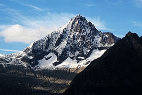
The Finsteraarhorn is a mountain lying on the border between the cantons of Bern and Valais. It is the highest mountain of the Bernese Alps and the most prominent peak of Switzerland. The Finsteraarhorn is the ninth-highest mountain and third-most prominent peak in the Alps. In 2001 the whole massif and surrounding glaciers were designated as part of the Jungfrau-Aletsch World Heritage Site.

Grindelwald is a village and municipality in the Interlaken-Oberhasli administrative district in the canton of Berne. In addition to the village of Grindelwald, the municipality also includes the settlements of Alpiglen, Burglauenen, Grund, Itramen, Mühlebach, Schwendi, Tschingelberg and Wargistal.
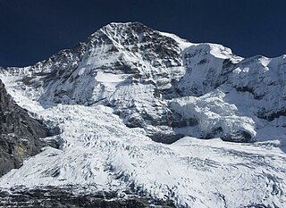
The Mönch at 4,110 metres (13,480 ft) is a mountain in the Bernese Alps, in Switzerland. Together with the Eiger and the Jungfrau, it forms a highly recognisable group of mountains, visible from far away.

The Jungfraujoch is a saddle connecting two major 4000ers of the Bernese Alps: the Jungfrau and the Mönch. It lies at an elevation of 3,463 metres (11,362 ft) above sea level and is directly overlooked by the rocky prominence of the Sphinx. The Jungfraujoch is a glacier saddle, on the upper snows of the Aletsch Glacier, and part of the Jungfrau-Aletsch area, situated on the boundary between the cantons of Bern and Valais, halfway between Interlaken and Fiesch.

The Aletschhorn is a mountain in the Alps in Switzerland, lying within the Jungfrau-Aletsch region, which has been designated a World Heritage Site by UNESCO. The mountain shares part of its name with the Aletsch Glacier lying at its foot.
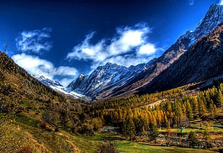
The Lötschental is the largest valley on the northern side of the Rhône valley in the canton of Valais in Switzerland. It lies in the Bernese Alps, with the Lonza running down the length of the valley from its source within the Langgletscher.

The Grünhorn is a mountain in the Bernese Alps range of the Swiss Alps. It is located on the ridge between the two largest glaciers of the Alps: the Aletsch Glacier to the west and the Fiescher Glacier to the east. To the south lies the Gross Wannenhorn and, to the north, the Gross Fiescherhorn.

Blatten is a village and municipality in the Lötschental valley in the canton of Valais in Switzerland. It is part of the district of Westlich Raron, and much of the municipality lies within the Jungfrau-Aletsch protected area, a World Heritage Site. Besides the village of Blatten, the municipality includes the settlements of Eisten, Fafleralp, Ried and Weissenried.
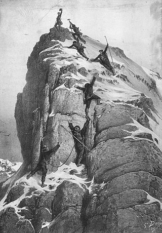
The golden age of alpinism was the decade in mountaineering between Alfred Wills's ascent of the Wetterhorn in 1854 and Edward Whymper's ascent of the Matterhorn in 1865, during which many major peaks in the Alps saw their first ascents.

The Eggishorn is a mountain in the southeastern part of the Bernese Alps, located north of Fiesch in the Swiss canton of Valais. A cable car station is located on a secondary summit named Fiescherhorli, 500 metres south of the main peak.

The Trugberg is a mountain in the Bernese Alps, located south of the Mönch in the canton of Valais, Switzerland. It is located above the Konkordiaplatz where the névé of the Jungfraufirn on the west side and the Ewigschneefeld on the east side converge to form the Aletsch Glacier. Debris accumulating on both sides of the mountain form one of the two important supraglacial moraines of the Aletsch Glacier.

The Lötschberg line is a railway in Switzerland, connecting Spiez in the canton of Bern with Brig in the canton of Valais. It crosses the Bernese Alps, from the Bernese Oberland to Upper Valais, through the Lötschberg Tunnel in the middle of the line. Together with the Simplon Tunnel south of Brig, it constitutes one of the major railways through the Alps and an important north-south axis in Europe. The Lötschberg axis is backed by the lower and longer Lötschberg Base Tunnel, part of the New Railway Links through the Alps project.
The Jungfrau-Aletsch protected area is located in south-western Switzerland between the cantons of Berne and Valais. It is a mountainous region in the easternmost side of the Bernese Alps, containing the northern wall of Jungfrau and Eiger, and the largest glaciated area in western Eurasia, comprising the Aletsch Glacier. The Jungfrau-Aletsch protected area is the first World Natural Heritage site in the Alps; it was inscribed in 2001.
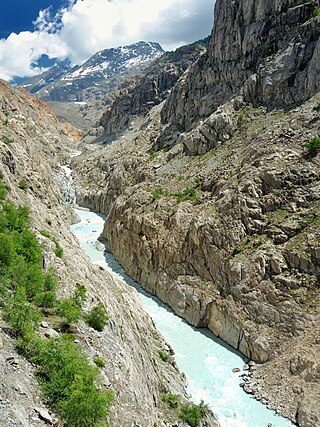
The Massa is a seven kilometre long river in the eastern Bernese Alps in the Swiss canton of Valais. It is mainly fed by the melt-water from the Aletsch Glacier. It passes through the Massa Gorge and flows into the Stausee Gibidum reservoir and onwards to its confluence with the Rhône.