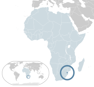
Eswatini, formally the Kingdom of Eswatini and also known by its former official name Swaziland, is a landlocked country in Southern Africa. It is bordered by Mozambique to its northeast and South Africa to its north, west, south, and southeast. At no more than 200 km (120 mi) north to south and 130 km (81 mi) east to west, Eswatini is one of the smallest countries in Africa; despite this, its climate and topography are diverse, ranging from a cool and mountainous highveld to a hot and dry lowveld.

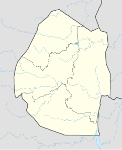
Eswatini, is a country in Southern Africa lying between Mozambique and South Africa. The country is located at the geographic coordinates 26°30′S31°30′E. Eswatini has an area of 17,363 square kilometres, of which 160 are water. The major regions of the country are Lowveld, Midveld and Highveld.
The Umbutfo Eswatini Defence Force (UEDF) is the military of the Southern African Kingdom of Eswatini (Swaziland). It is used primarily during domestic protests, with some border and customs duties; the force has never been involved in a foreign conflict. The army has struggled with high rates of HIV infection. Since measures were put in place the rate is dropping.

Eswatini is a member of the United Nations, the Commonwealth of Nations, the African Union, the Common Market for Eastern and Southern Africa, and the Southern African Development Community. Currently, the Kingdom of Eswatini maintains 11 embassies and High Commissions along with 15 consulates and other representations around the world, while there are five embassies and High Commissions in Eswatini as well as 14 consulates and other representations.

Mbabane is a city in Eswatini, and is one of the two capitals, serving as the executive capital.

Mswati III is Ngwenyama (King) of Eswatini and head of the Swazi royal family.
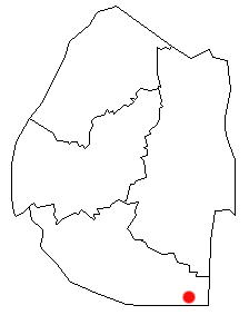
Lavumisa is a town located in the Shiselweni district of southern Eswatini.
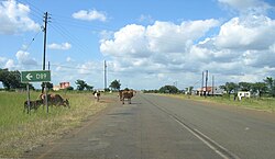
Siphofaneni is a town in the Lubombo Region of central Eswatini (Swaziland), 45 kilometres from Manzini and 20 kilometres from Big Bend, a major sugarcane-producing town on the main highway leading to Durban. It has a tropical climate, very hot during summer and cold in winter. Malaria is endemic in Lubombo. Siphofaneni has hot springs and is surrounded by several sugarcane farms. It is located on the banks of the largest river in Swaziland, the Usutu.
Lesbian, gay, bisexual, and transgender (LGBT) people in Eswatini have limited legal rights. According to Rock of Hope, a Swati LGBT advocacy group, "there is no legislation recognising LGBTIs or protecting the right to a non-heterosexual orientation and gender identity and as a result [LGBT people] cannot be open about their orientation or gender identity for fear of rejection and discrimination". Homosexuality is illegal in Eswatini, though this law is in practice unenforced. According to the 2021 Human Rights Practices Report from the US Department of State, "there has never been an arrest or prosecution for consensual same-sex conduct."
HIV/AIDS in Eswatini was first reported in 1986 but has since reached epidemic proportions. As of 2016, Eswatini had the highest prevalence of HIV among adults aged 15 to 49 in the world (27.2%).

The Maguga Dam is a dam on the Komati River in Eswatini. It is 115 metres (377 ft) high and is located about 12 kilometres (7.5 mi) south of Piggs Peak. It was built as a joint project of the governments of South Africa and Eswatini. As of 2005, it was the largest public works project ever undertaken by Eswatini. The dam was completed in mid-2001.
Hawane Nature Reserve was first established in 1978 to protect an area of marsh along the Mbuluzi River in Eswatini. This area included the natural habitat of Kniphofia umbrina, a rare Eswatini endemic red hot poker. When the Hawane dam was built in 1988 to provide Mbabane's water supply, the reserve was expanded to protect the surrounding wetlands. The reserve is managed by the Swaziland National Trust Commission.

Malolotja National Park covers 18,000 hectares of mountain wilderness on Eswatini's northwestern border with South Africa. The park includes Ngwenya Mountain, Eswatini's second highest mountain, and Malolotja Falls which drop 89 metres (292 ft), the highest in Eswatini. Habitats include short grassland to thick riverine scrub, bushveld and Afromontane forest.
The Mlawula Nature Reserve is a nature reserve situated in north-eastern Eswatini. It covers approximately 16,500 hectares and is adjacent to Mbuluzi Game Reserve, Simunye Nature Reserve, and Hlane Royal National Park.

Tatenda Mandaza, known professionally as Tendaness, is a Swazi-born record producer, DJ and songwriter.

Ambrose Mandvulo Dlamini was a Swazi business executive who served as the tenth prime minister of Eswatini, holding the office from October 2018 until his death on 13 December 2020.

The climate of Liverpool features a temperate maritime variety, with relatively mild summers, cool winters and rainfall spread fairly evenly throughout the year. Since 1867, rainfall and temperature records for the city have been kept at Bidston Observatory, as well as atmospheric pressure records since 1846. However, the site closed down in 2002, and a weather station in Crosby has been used by the Met Office since. Irregular meteorological observations have been taken in the city since at least 1768, with unbroken records extending for long periods of time. This includes observations taken at the Liverpool Dock from 1768 to 1798, an unspecified location from 1772 to 1799 and West Derby from 1830 to 1859 and at other unspecified locations in the city from at least 1860 onward. Continuous observations in different areas of the city have been taken since 1830. In modern times, there have also been other stations to operate in the Liverpool area, including stations at West Kirby (1912–1979), Aigburth (1967–1994), and Liverpool John Lennon Airport (1946–present).

Eswatini–Taiwan relations refer to the international relations between the Kingdom of Eswatini and Republic of China (Taiwan). Eswatini maintains an embassy in Taipei, and Taiwan maintains an embassy in Mbabane.
A series of protests in Eswatini against the absolute monarchy and for democratisation began in late June 2021. Starting as a peaceful protest on 20 June, they escalated after 25 June into violence and looting over the weekend as the government took a hardline stance against the demonstrations and prohibited the delivery of petitions.