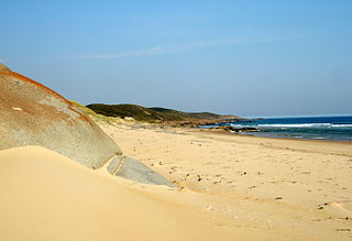
The Croajingolong National Park is a coastal national park located in the East Gippsland region of the Australian state of Victoria. The 88,355-hectare (218,330-acre) national park is situated approximately 450 kilometres (280 mi) east of Melbourne and 500 kilometres (310 mi) south of Sydney.

The Murray-Sunset National Park is the second largest national park in Victoria, Australia, located in the Mallee district in the northwestern corner of the state, bordering South Australia. The 633,000-hectare (1,560,000-acre) national park is situated approximately 440 kilometres (270 mi) northwest of Melbourne and was proclaimed in 1991. It is in the northwestern corner of the state, bordering South Australia to the west and the Murray River to the north. The Sturt Highway passes through the northern part of the park, but most of the park is in the remote area between the Sturt Highway and the Mallee Highway, west of the Calder Highway.

The Wyperfeld National Park is the third largest national park in Victoria, Australia, located in the Mallee district, approximately 450 kilometres (280 mi) northwest of Melbourne, The national park was declared in 1921 and expanded significantly to protect 357,017 hectares of mallee, woodland, and heathland. For management purposes, the Wyperfeld National Park is managed with the Hattah-Kulkyne National Park, Murray-Sunset National Park, Lake Albacutya Park and Murray-Kulkyne Park as part of the Victorian Mallee Parks.

The Lamington National Park is a national park, lying on the Lamington Plateau of the McPherson Range on the Queensland/New South Wales border in Australia. From Southport on the Gold Coast the park is 85 kilometres (53 mi) to the southwest and Brisbane is 110 kilometres (68 mi) north. The 20,600 hectares Lamington National Park is known for its natural environment, rainforests, birdlife, ancient trees, waterfalls, walking tracks and mountain views. The park protects parts of the Eastern Australian temperate forests.
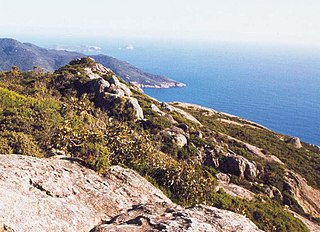
Wilsons Promontory, also known as Yiruk and Wamoon in the Gunai and Boonwurrung languages respectively, is a peninsula that forms the southernmost part of the Australian mainland, located in the state of Victoria.
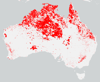
Fire-stick farming, also known as cultural burning and cool burning, is the practice of Aboriginal Australians regularly using fire to burn vegetation, which has been practised for thousands of years. There are a number of purposes for doing this special type of controlled burning, including to facilitate hunting, to change the composition of plant and animal species in an area, weed control, hazard reduction, and increase of biodiversity.

Munga-Thirri–Simpson Desert National Park, part of which was formerly Munga-Thirri–Simpson Desert Conservation Park, Simpson Desert Conservation Park, and Simpson Desert National Park, is a protected area located in the far north of the Australian state of South Australia, near its border with Queensland and the Northern Territory. As of November 2021 it is the largest national park in Australia, covering 3,600,000 ha (14,000 sq mi).

Ngarkat Conservation Park is a protected area located in South Australia's south-eastern corner about 200 kilometres south east of the Adelaide city centre.

The mallee emu-wren is a species of bird in the Australasian wren family, Maluridae. It is endemic to Australia.

The 2007 Kangaroo Island bushfires were a series of bushfires caused by lightning strikes on 6 December 2007 on Kangaroo Island, South Australia, resulting in the destruction of 95,000 hectares of national park and wilderness protection area. The fires occurred mainly across the western side of the island near Flinders Chase National Park, Vivonne Bay, D'Estrees Bay, Western River and Riverleas.

The Shire of Walpeup was a local government area in northwestern Victoria, Australia, along the South Australian border. The shire covered an area of 10,964 square kilometres (4,233.2 sq mi), and existed from 1911 until 1995.

The Corner Inlet is a 600-square-kilometre (230 sq mi) bay located 200 kilometres (120 mi) south-east of Melbourne in the South Gippsland region of Victoria, Australia. Of Victoria's large bays it is both the easternmost and the warmest. It contains intertidal mudflats, mangroves, salt marsh and seagrass meadows, sheltered from the surf of Bass Strait by a complex of 40 sandy barrier islands, the largest of which are Snake, Sunday and Saint Margaret Islands.

The Bundara River, a perennial river of the North-East Murray catchment of the Murray-Darling basin, is located in the East Gippsland and Alpine regions of Victoria, Australia.

The Wyperfeld, Big Desert and Ngarkat Important Bird Area comprises a 9743 km2 tract of semiarid mallee woodlands and shrublands in south-eastern Australia, straddling the border between the states of South Australia and Victoria.
Bushfires were mostly active between September 2011 to March 2012 and caused most damage in the state of Western Australia, particularly in the South West. The state had been prepared and had expected an increased risk of bushfire following heavy spring rains as a result of a La Nina weather pattern.
Big Desert is a locality in the Australian state of Victoria located in the state's west adjoining the border with South Australia within the local government areas of the Shire of Hindmarsh, the Rural City of Mildura and the Shire of West Wimmera. The principal land use is conservation with part of the locality being occupied by the following protected areas:
Ngarkat were an indigenous Australian people of South Australia.
