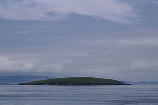
Geography and geology
Just over 1,000 metres (1,100 yd) long, Bigga is 78 hectares (0.30 sq mi) in size, and is 34 metres (112 ft) tall at its highest point. Bigga is a long thin island with a "head" and a "torso". The neck is formed by the bays of Wester Hevda Wick and Easter Hevda Wick, "hevda wick" being an anglicisation of the Norn/Old Norse for "seaweed bay".
Cattle and sheep were formerly farmed here.
The island belongs at the same time in common to the civil parishes of Delting and Yell. [6] [7]
Bigga consists of Moine bedrock of coarsely-crystalline gneiss and quartzite. [3]
History
It is thought that the name comes from the Old Norse bygðey meaning "island of the building", which may refer to an old structure.
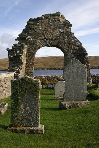
In the southern part of the island, there is an old well, chapel and burial ground. There is a small prehistoric cairn in the north of the island. In the north is the remains of Norrabister, the island's "settlement".
The Pribislaw, a 160-year-old German sailing vessel ran aground here in 1870. She had been one of many sailing boats that took German emigrants from Hamburg to Victoria, in Australia, around the middle of the 19th century. Moved to Lerwick, she was used as a store and workshop until the 1950s. In 2005 the remaining timbers were excavated and transported to Whittlesea, Australia. [8]
During World War II, two sailors from neighbouring Yell wanted to return to their native island to celebrate Yule (Christmas) during their shore leave. The weather was stormy and snowy and the usual ferry between the Mainland and Yell was not running, so they borrowed a friend's boat. Forced to land on Bigga, they sheltered in the bothy and danced, and played the fiddle in order to stay warm. They managed to reach Yell the next day. [3]
Yell is one of the North Isles of Shetland, Scotland. In the 2011 census it had a usually resident population of 966. It is the second largest island in Shetland after the Mainland with an area of 82 square miles (212 km2), and is the third most populous in the archipelago, after the Mainland and Whalsay.
Unst is one of the North Isles of the Shetland Islands, Scotland. It is the northernmost of the inhabited British Isles and is the third-largest island in Shetland after Mainland and Yell. It has an area of 46 sq mi (120 km2).
Papa Stour is one of the Shetland Islands in Scotland, with a population of under fifteen people, some of whom immigrated after an appeal for residents in the 1970s. Located to the west of mainland Shetland and with an area of 828 hectares, Papa Stour is the eighth largest island in Shetland. Erosion of the soft volcanic rocks by the sea has created an extraordinary variety of caves, stacks, arches, blowholes, and cliffs. The island and its surrounding seas harbour diverse populations of wildlife. The west side of the island is a Site of Special Scientific Interest and the seas around the island are a Special Area of Conservation.

Whalsay is the sixth largest of the Shetland Islands in the north of Scotland.

Mousa is a small island in Shetland, Scotland, uninhabited since the nineteenth century. The island is known for the Broch of Mousa, an Iron Age round tower, and is designated as a Special Protection Area for storm-petrel breeding colonies.

Muckle Roe is an island in Shetland, Scotland, in St. Magnus Bay, to the west of Mainland. It has a population of around 130 people, who mainly croft and live in the south east of the island.

Vementry is an uninhabited Scottish island in Shetland on the north side of the West Mainland, lying south of Muckle Roe.
Uyea is an uninhabited island, lying south of Unst in Shetland, Scotland.

South Havra, formerly Hevera, is an uninhabited island in the Scalloway Islands, Shetland, Scotland.

Haroldswick or Harold's Wick, is on Unst, Shetland Islands, Scotland, and is one of the most northerly settlements in the British Isles.

Samphrey is an uninhabited island in the Shetland Islands, Scotland. One of Fair Isle's old names is "Friðarey" which is of similar origin.

Northmavine or Northmaven is a peninsula in northwest Mainland Shetland in Scotland. The peninsula has historically formed the civil parish Northmavine. The modern Northmavine community council area has the same extent. The area of the parish is given as 204.1 km2.
Uynarey is one of the Shetland islands in Yell Sound, just to the north of Bigga, and east of Brother Island. It is an RSPB reserve. The name comes from the Norse for "venerated island", and this may reflect a Culdee connection.

Little Roe is an island in Yell Sound in the Shetland Islands

Gloup Holm is an islet in the Shetland Islands, lying to the north of Yell.

Yell Sound is the strait running between Yell and Mainland, Shetland, Scotland. It is the boundary between the Mainland and the North Isles and it contains many small islands. Sullom Voe, on the shores of which is a substantial oil terminal, is an arm of Yell Sound.
Sandsting is a parish in the West Mainland of Shetland, Scotland, forming a southern arm of the Walls Peninsula. After the parish of Aithsting was annexed into Sandsting in the sixteenth century, it became known as Sandsting and Aithsting parish.

Sandwick is an ancient parish in the Shetland Islands, Scotland. It was merged in 1891, along with Cunningsburgh, into Dunrossness. It is located 13 miles (21 km) south of Lerwick in the South Mainland. It comprises a number of distinct settlements in very close proximity to each other, each remaining distinct through being separated by agricultural land. These settlements within Sandwick include Old Sandwick, Leebitton, Broonies' Taing, Stove, Swinister and Hoswick; the latter is almost a village in its own right and is often considered distinct from Sandwick.

St Magnus Bay is a large coastal feature in the north-west of Mainland Shetland, Scotland. Roughly circular in shape with a diameter of about 19 kilometres (12 mi), it is open to the North Atlantic Ocean to the west. The indented coastline to the north, south and east between Esha Ness in the north and the Ness of Melby in the south contains numerous bays, firths and voes and there are several islands around the perimeter. The waters of the bay are up to 165 metres (541 ft) deep and may have been the site of a substantial meteor impact.


