Bilhorod-Dnistrovskyi fortress

Last updated
Bilhorod-Dnistrovskyi fortress
Akkerman fortress
Bilhorod-Dnistrovskyi, Odesa Oblast
Bilhorod Dnistrovskyi.jpg
Ukraine under russian occupation grey.svg
Red pog.svg
Bilhorod-Dnistrovskyi fortress
Akkerman fortress
Coordinates 46°12′3.96″N30°21′2.16″E / 46.2011000°N 30.3506000°E / 46.2011000; 30.3506000
Bilhorod-Dnistrovskyi fortress

Bilhorod-Dnistrovskyi fortress or Akkerman fortress (also known as Kokot) is a historical and architectural monument of the 13th-14th centuries. It is located in Bilhorod-Dnistrovskyi in the Odesa Oblast of southwestern Ukraine, the historical Budjak.

Contents

Bilhorod-Dnistrovskyi fortress video

History

Start of construction

Citadel Akermans'ka fortetsia. Genuez'kii zamok (tsitadel') 03.jpg
Citadel
Ukraine postal stamp with fortress Stamps of Ukraine, 2014-31.jpg
Ukraine postal stamp with fortress

The fortress was built on the remains of Tyras, an ancient Greek city on the northern coast of the Black Sea which existed until the 4th century. Frequent attacks by invaders - first the Goths, then the Huns - destroyed the city. Antes, Slavs and Bulgarians lived on the site of Tyras after the Greeks. [1] In the 10th century Bilhorod was part of Kievan Rus'’. Later it was owned by the Kingdom of Hungary, then the Principality of Galicia–Volhynia, where it stayed until the invasion of the Mongols.[ citation needed ]

It is not known when construction began on the fortress. Most historians today believe that it was a trading enclave of the Republic of Genoa on the Black Sea, first established in the 13th century. The territory was surrendered to the Golden Horde, but the Genoese managed to ally with the Mongols. Bilhorod was officially the Tatars’ city, but it was ruled by the Genoese. The fortress controlled the Dniester estuary.[ citation needed ]

In the second half of the 14th century the Genoese lost their influence in the Black Sea region, and safe passage across the Aegean Sea, because of increasing military pressure from the Ottomans. According to most historians, Lithuania came to replace Genoa. In the 14th century the Principality of Moldavia gained control over the Lithuanians.[ citation needed ]

Moldavian period

After the territory came under the control of the Principality of Moldavia, the Moldavians started to call Bilhorod "Cetatea Alba" (literally White Citadel). In the 15th century the city was a metropolis with about 20,000 inhabitants - Moldavians, Greeks, Genoese, Armenians, Jews, Tatars. It was the start of the greatest development period in the city's history. The city was based on a fortress, which had already grown significantly. Its main elements had been constructed by 1440. The fortress had 34 towers, some as much as 20 meters tall. Outside, the fortress was surrounded by a deep moat. The fortress was built of white limestone, for which a mortar made of eggs, crushed marble, carbon, and silicon was used.[ citation needed ]

In 1440 one portion which was neither a wall nor a castle tower was completed. This segment is located outside the castle walls very close to the estuary and has remains preserved today. Inside the wall, 10 stone cores were inlaid in the wall as a kind of talisman. This part of the wall had no practical defensive value. For a long time historians and architects could not identify the purpose of it.[ citation needed ]

The cores inside the wall were shaped like a tetractys: a figure with ten points that form nine equilateral triangles. Possibly this was a magical symbol used in Druidic rituals. It is also one of the symbols of Masonic lodges. [2] This confirms the view of many historians that the Bilhorod-Dnistrovskyi fortress was built by Freemasons and the incomprehensible portion was made specifically for the tetractys. Also, a plate was found in one of the towers, inscribed with: "Master Fedorko finished construction in 1440". Master was a name for the head of the Masonic lodge.[ citation needed ]

Another explanation of Bilhorod's tetractys is much more pragmatic: some claim it is just a variant of a sundial calendar.[ citation needed ]

In the second half of the 15th century, the Moldavian principality was marred by a civil war between different factions, and king Bogdan II was murdered in an ambush by his brother Peter III Aaron in 1451. In 1457, the throne of Moldavia was captured by Stephen III of Moldavia (son of Bogdan II) with the help of his cousin Vlad the Impaler, prince of Wallachia. Since Cetatea Alba was the main defensive center in the southeast of the state, located right on the trade route between Europe and Asia, it was given renewed attention under a new ruler. The fortress was constructed and reinforced with new stronger walls and a large gate, which then served as the main entrance to the fortress. In order to guard it, a permanent garrison was placed.[ citation needed ]

Ottoman period

In the 15th century, The Ottoman Empire repeatedly tried to capture the city. The hardest siege was in August 1484, when a 300,000-man army of Ottoman sultan Bayezid II and 50,000 troops of the Crimean Khan Meñli I Giray, supported by over 100 large ships, besieged the castle from the coast and estuary. After a nine-day siege, the fortress was taken. In 1485, Stephen the Great tried to recapture Bilhorod, but failed. Turks would rule there for 328 years.[ citation needed ]

The Ottoman Empire made Bilhorod one of its strongholds in the north. The city suffered from endless attacks by the Zaporozhian Cossacks. Cossack chieftains repeatedly tried to sack the city - Hryhoriy Loboda, Severyn Nalivaiko, Ivan Sulima, Ivan Sirko, and Semen Paliy. Moldavians and Poles did not leave the city in peace either. However, Bilhorod remained an impregnable stronghold. Much attention to the fortress was also paid by the vassals of Turkey: Crimean Tatars. Bilhorod was often a place of refuge during the campaigns, and the Crimean Khan İslâm II Giray even died in the fortress and was buried in the mosque, of which only one minaret now remains.[ citation needed ]

During the long Turkish domination, the Bilhorod fortress was repeatedly rebuilt and renovated with new fortifications. In 1657 Melek Ahmed Pasha significantly strengthened the fortress. In 1707, the Turks invited French military engineers, who constructed a new bastion line. After 1756, consolidation and repairs were made to the fortress almost every year.[ citation needed ]

The 18th century saw three Russian-Turkish wars. First, in 1770, the fortress was invaded by the Russian army. The Russian invaders could not stay there long, and, according to Treaty of Küçük Kaynarca, finally returned to the city[ clarification needed ] in 1774. In 1789, the town was captured without a fight by a large detachment of Don Cossacks and a Jäger (infantry) hunter corps headed by Mikhail Kutuzov. The following year, Kutuzov became commander of the fortress, but had to leave this position soon after. According to the agreement between Russia and the Ottoman Empire, the river Dniester was their border. The Ottoman period of Bilhorod ended in 1812, following the Russo-Turkish war of 1806-1812, when Russia took the eastern part of the Principality of Moldavia, between the Prut and Dniester rivers. The Treaty of Bucharest (1812) put Bessarabia (including Budjak) and Bilhorod under the control of the Russian Empire.

The Akkerman Convention was signed in 1826 between the Russian and the Ottoman empires. This treaty expanded Russian influence in the Danube region and established a framework for the eventual independence of Moldavia and Wallachia. [3]

20th century

In 1918, Romania briefly reestablished control over Budjak, after the unification of Romania and Bessarabia in 1918, but the Soviets reclaimed the city and the surrounding territory in 1940 and again in 1944.[ citation needed ]

Preservation

In 2009, the Bilhorod-Dnistrovskyi fortress was added to the State Register of Immovable Landmarks of Ukraine. [4] In 2019, together with the remains of the city of Tyras, the fortress was listed on the UNESCO World Heritage Site Tentative List. [5]

Related Research Articles

<span class="mw-page-title-main">Kosivka, Odesa Oblast</span> Rural locality in Odesa Oblast, Ukraine

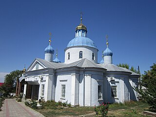
Kosivka is a village in Ukraine of Bilhorod-Dnistrovskyi Raion (sub-region) of Odesa Oblast (region). It belongs to Serhiivka settlement hromada, one of the hromadas of Ukraine. The population of the village is 258 people.

<span class="mw-page-title-main">Bilhorod-Dnistrovskyi</span> City in Odesa Oblast, Ukraine

Bilhorod-Dnistrovskyi, historically known as Aq Kirmān or by other names, is a port city in Odesa Oblast, southwestern Ukraine. It is situated on the right bank of the Dniester Estuary leading to the Black Sea, in the historical region of Budjak. It also serves as the administrative center of Bilhorod-Dnistrovskyi Raion and is coterminous with Bilhorod-Dnistrovskyi urban hromada, one of the hromadas of Ukraine. It is the location of a large freight seaport. Population: 47,727.

<span class="mw-page-title-main">Budjak</span> Historical region in southwestern Ukraine

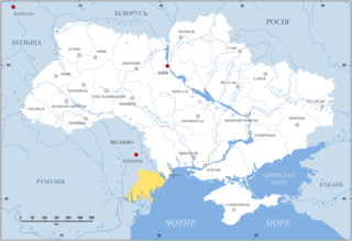
Budjak, also known as Budzhak, is a historical region that was part of Bessarabia from 1812 to 1940. Situated along the Black Sea, between the Danube and Dniester rivers, this multi-ethnic region covers an area of 13,188 km2 (5,092 sq mi) and is home to approximately 600,000 people. The majority of the region is now located in Ukraine's Odesa Oblast, while the remaining part is found in the southern districts of Moldova. The region is bordered to the north by the rest of Moldova, to the west and south by Romania, and to the east by the Black Sea and the rest of Ukraine.

<span class="mw-page-title-main">Khotyn</span> City in Chernivtsi Oblast, Ukraine

Khotyn is a city in Dnistrovskyi Raion, Chernivtsi Oblast of western Ukraine, located south-west of Kamianets-Podilskyi. It hosts the administration of Khotyn urban hromada, one of the hromadas of Ukraine. According to the 2001 Ukrainian census, it has a population of 11,124. Current population: 8,936.

<span class="mw-page-title-main">Ochakiv</span> City in Mykolaiv Oblast, Ukraine

Ochakiv, also known as Ochakov, and Alektor, is a small city in Mykolaiv Raion, Mykolaiv Oblast (region) of southern Ukraine. It hosts the administration of Ochakiv urban hromada, one of the hromadas of Ukraine. Population: 13,663.

<span class="mw-page-title-main">Sarata</span> Rural locality in Odesa Oblast, Ukraine

Sarata is a rural settlement in Bilhorod-Dnistrovskyi Raion, Odesa Oblast (region) of south-western Ukraine. It is a part of the Bessarabian historic district of Budjak. Sarata hosts the administration of Sarata settlement hromada, one of the hromadas of Ukraine. Population: 4,159.

<span class="mw-page-title-main">Tatarbunary</span> City in Odesa Oblast, Ukraine

Tatarbunary is a city in Bilhorod-Dnistrovskyi Raion, Odesa Oblast (province) of south-western Ukraine. It hosts the administration of Tatarbunary urban hromada, one of the hromadas of Ukraine. Tatarbunary is located north of the Danube Delta, in Budjak area, approximately 100 kilometers (62 mi) south-west of the oblast center, Odesa, close to Sasyk Lagoon. Population: 10,836.

<span class="mw-page-title-main">Tyras</span> Ancient Greek city-state in Ukraine

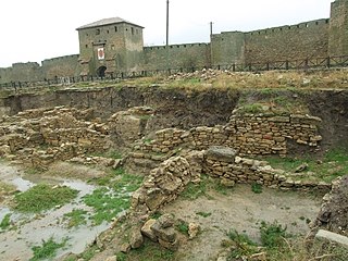
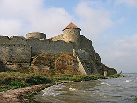
Tyras was an ancient Greek city on the northern coast of the Black Sea. It was founded by colonists from Miletus, probably about 600 BC. The city was situated some 10 km from the mouth of the Tyras River, which is now called the Dniester. The surrounding native tribe was called the Tyragetae. The ruins of Tyras are now located in the modern city of Bilhorod-Dnistrovskyi in the Odesa Oblast of Ukraine.

<span class="mw-page-title-main">Yedisan</span> Historical region in Ukraine

Yedisan was a conditional name for Özi [Paşa] Sancağı of Silistra Eyalet, a territory located in today's Southern Ukraine between the Dniester and the Southern Bug (Boh), which was placed by the Ottomans under the control of the Nogai Horde in the 17th and 18th centuries and was named after one of the Nogai Hordes. In the Russian Empire, it was referred to as Ochakov Oblast, while the Ottoman Turks called it simply Özü after the city of Ochakiv which served as its administrative center. Another name used was Western Nogai.

<span class="mw-page-title-main">History of Transnistria</span>

This is the history of Transnistria, officially the Pridnestrovian Moldavian Republic (PMR), an unrecognised breakaway state that is internationally recognised as part of Moldova. Transnistria controls most of the narrow strip of land between the Dniester river and the Moldovan–Ukrainian border, as well as some land on the other side of the river's bank.

<span class="mw-page-title-main">Dniester Estuary</span>

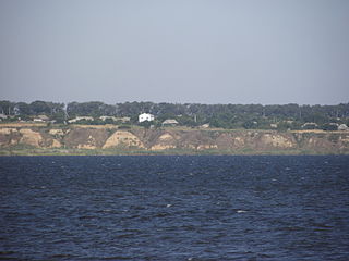
Dniester Estuary, or Dniester Liman is a liman, formed at the point where the river Dniester flows into the Black Sea. It is located in Ukraine, in Odesa Oblast, and connects Budjak to the Ukrainian mainland. The city of Bilhorod-Dnistrovskyi lies on its western shore and Ovidiopol on its eastern shore. Shabo, situated downstream of Bilhorod-Dnistrovskyi, is known for its wine. The estuary hosts the Bilhorod-Dnistrovsky Seaport.

<span class="mw-page-title-main">Ovidiopol</span> Rural settlement in Odesa Oblast, Ukraine

Ovidiopol is a coastal rural settlement in Odesa Oblast, Ukraine. It is located on the eastern bank of Dniester Estuary directly across Bilhorod-Dnistrovskyi and 40 km (25 mi) west of Odesa. Ovidiopol hosts the administration of Ovidiopol settlement hromada, one of the hromadas of Ukraine. Population: 11,407.

<span class="mw-page-title-main">Akkerman Convention</span> Treaty signed on October 7, 1826, between the Russian and the Ottoman Empires

The Akkerman Convention was a treaty signed on October 7, 1826, between the Russian and the Ottoman Empires in the Budjak citadel of Akkerman. It imposed that the hospodars of Moldavia and Wallachia be elected by their respective Divans for seven-year terms, with the approval of both Powers. It also provided for the retreat of Ottoman forces from both Danubian Principalities after their prolonged stay following military actions in 1821, and Tudor Vladimirescu's uprising. The Ottomans also agreed to cede to Wallachia the control over the Danube ports of Giurgiu, Brăila and Turnu. The convention also tackled the Serbian question: in article 5, autonomy for the Principality of Serbia was given, and the return of lands removed in 1813. Serbs were also granted freedom of movement through the Ottoman Empire.

<span class="mw-page-title-main">Khotyn Fortress</span> Fortress complex in Chernivtsi Oblast, Ukraine

The Khotyn Fortress is a fortification complex located on the right bank of the Dniester River in Khotyn, Chernivtsi Oblast (province) of southwestern Ukraine. It lies within the historical region of northern Bukovina, a Romanian territory occupied in 1940 by the Soviet Union following the Molotov–Ribbentrop Pact. The fortress is located near another famous defensive structure, the Kamianets-Podilskyi Castle. Construction of the current stone Khotyn Fortress began in 1375. The fortress underwent significant improvements in the 1380s and in the 1460s under the Moldavian princes Alexander the Good and Stephen the Great.

This deals with the History of Transnistria before it became part of the Russian Empire in 1792.

<span class="mw-page-title-main">Zatoka, Odesa Oblast</span> Rural locality in Odesa Oblast, Ukraine

Zatoka is a rural settlement in Bilhorod-Dnistrovskyi Raion, Odesa Oblast, in southwestern Ukraine. It belongs to Karolino-Buhaz rural hromada, one of the hromadas of Ukraine. The population of Zatoka is 1,972. Its name comes from the Ukrainian-language word zatoka, meaning "bay".

The town of Maurocastrum, also known historically as Cetatea Alba in Romanian, was a settlement on the banks of the Dniester River, now the city of Bilhorod-Dnistrovskyi, Ukraine, in the 6th century BC. It later came under successive Greek, Roman and Byzantine rule. Under the Treaty of Nymphaion of 1261, the city came under the control of the Republic of Genoa. Called Mauricastro by them, it then became a base for trading by Genoese merchants with both the Byzantine Empire and the Mongol Empire.

<span class="mw-page-title-main">Budjak Horde</span>

The Budjak Horde or Belgorod Horde formed part of the Nogai Horde in the 17th and 18th centuries. It settled in the northern Black Sea coast area under protectorate of the Crimean Khanate and the Ottoman Empire's Sanjak of Ozu (Yedisan). Its capital was in Căușeni.

<span class="mw-page-title-main">Odesa Oblast</span> Oblast (region) of Ukraine

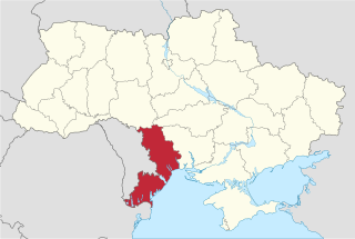
Odesa Oblast, also referred to as Odeshchyna (Одещина), is an oblast (province) of southwestern Ukraine, located along the northern coast of the Black Sea. Its administrative centre is the city of Odesa. Population: 2,351,382.

Battle of Chițcani (1683) was a battle of the united Cossack troops of the Polish-Lithuanian Commonwealth under the command of the Right-bank Hetman Stefan Kunicki and Moldavian army Ștefan Petriceicu with detachments of the Budjak Horde on 5 December 1683 during the Kunicki's expedition on the Right-bank and Moldavia at the beginning of the Polish-Ottoman War (1683–1699).

References

  1. Karyshkovskij, Petr O.; Kleiman, Isaac B. (1994). The City of Tyras: A Historical and Archaeological Essay. Odesa: Polis Press. ISBN   9785770745313.
  2. http://www.masonicdictionary.com/tetractys.html
  3. Jelavich, Charles (1986). The Establishment of the Balkan National States, 1804-1920. University of Washington Press. ISBN   0-295-96413-8.{{cite book}}: CS1 maint: date and year (link)
  4. "Державний реєстр нерухомих пам'яток України". Міністерство культури та інформаційної політики України (in Ukrainian). 2022-01-14. Retrieved 2023-07-01.
  5. "Tyras - Bilhorod (Akkerman), on the way from the Black Sea to the Baltic Sea". UNESCO World Heritage Centre. Archived from the original on 18 September 2021. Retrieved 2023-07-01.