
Harwell is a village and civil parish in the Vale of White Horse about 2 miles (3 km) west of Didcot, 6 miles (10 km) east of Wantage and 13 miles (21 km) south of Oxford. The parish measures about 3.5 miles (6 km) north – south, and almost 2 miles (3 km) east – west at its widest point. In 1923 its area was 2,521 acres (1,020 ha). Historically in Berkshire, it has been administered as part of Oxfordshire, England, since the 1974 boundary changes. The parish includes part of Harwell Science and Innovation Campus in the southwest. The 2011 census recorded the parish's population as 2,349.

Boscobel House is a Grade II* listed building in the parish of Boscobel in Shropshire. It has been, at various times, a farmhouse, a hunting lodge, and a holiday home; but it is most famous for its role in the escape of Charles II after the Battle of Worcester in 1651. Today it is managed by English Heritage.

Hurst is a village in the civil parish of St Nicholas Hurst in the Borough of Wokingham, Berkshire, England. The village lies between Twyford and Wokingham, about 1.5 miles (2.4 km) north of the M4 motorway.

Nettlebed is a village and civil parish in Oxfordshire in the Chiltern Hills about 4+1⁄2 miles (7 km) northwest of Henley-on-Thames and 6 miles (10 km) southeast of Wallingford. The parish includes the hamlet of Crocker End, about 1⁄2 mile (800 m) east of the village. The 2011 Census recorded a parish population of 727.

Bletchingley is a village in Surrey, England. It is on the A25 road to the east of Redhill and to the west of Godstone, has a conservation area with medieval buildings and is mostly on a wide escarpment of the Greensand Ridge, which is followed by the Greensand Way.

Pontrobert is an ecclesiastical parish that was formed in September 1854. It comprises the townships of Teirtref and part of Nantymeichiaid in the parish Meifod, a portion of Cynhinfa which was in the parish of Llangynyw and portions of the townships of Fachwel, Llaethbwlch and Cadwnfa which were in the parish of Llanfihangel. The total area of this parish is 5,000 acres. As a result of this arrangement, Pont Robert is now divided between the present day Community Councils of Meifod, Llangyniew and Mawddwy. Pontrobert was within the historic county of Montgomeryshire, now forming part of Powys. The name Pontrobert is derived from Robert ap Oliver of Cyhinfa, who built the original bridge over the River Vyrnwy around 1700. An alternative Welsh name for Pontrobert is Pont y ddolfeiniog.
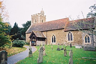
Binfield is a village and civil parish in Berkshire, England, which at the 2011 census had a population of 8,689. The village lies 2 miles (3.2 km) north-west of Bracknell, 3 miles (4.8 km) north-east of Wokingham, and 8 miles (13 km) south-east of Reading at the westernmost extremity of the Greater London Urban Area.

Rotherfield Greys is a village and civil parish in the Chiltern Hills in South Oxfordshire. It is 2 miles (3 km) west of Henley-on-Thames and just over 1 mile (1.6 km) east of Rotherfield Peppard. It is linked by a near-straight minor road to Henley.

Thorpe is a village in northwest Surrey, England, around 20 miles (32 km) west of central London. It is in the Borough of Runnymede, between Egham, Virginia Water and Chertsey. It is adjacent to the M25, near the M3 — its ward covers 856 hectares (3.3 sq mi). Its traditional area with natural boundaries covers one square mile less. Thorpe is a former civil parish.

Denchworth is a village and civil parish about 2.5 miles (4 km) north of Wantage. It was part of Berkshire until the 1974 boundary changes transferred the Vale of White Horse to Oxfordshire. The 2011 Census recorded the parish's population as 171. The parish is bounded by the Land Brook in the west and the Childrey Brook in the east. The Great Western Main Line between Reading and Swindon runs through the parish just south of the village, but there is no station.

Wincheap is a road and suburb in Canterbury, Kent, England. The road forms part of the A28 road, stretching for around 1 mile (1.6 km) from the city wall, close by Canterbury East railway station, to the over-crossing of the A2 and the parish of Thanington.

Hatherton is a hamlet and civil parish in the unitary authority of Cheshire East and the ceremonial county of Cheshire, England. The hamlet is on the B5071 at SJ687474, 2+3⁄4 miles (4.4 km) to the north east of Audlem and 3+3⁄4 miles (6.0 km) to the south east of Nantwich. The civil parish has an area of 673 hectares and also includes the small settlements of Birchall Moss, Broomlands and part of Artlebrook, with a total population of 360 in 2011. Nearby villages include Hankelow, Stapeley, Walgherton, Wybunbury, Blakenhall and Buerton. The A529 runs through the parish and the River Weaver forms the western boundary.

Lyford is a village and civil parish on the River Ock about 4 miles (6.4 km) north of Wantage. Historically it was part of the ecclesiastical parish of Hanney. Lyford was part of Berkshire until the 1974 boundary changes transferred the Vale of White Horse to Oxfordshire. The 2001 Census recorded the parish's population as 44. Lyford's toponym refers to a former ford the Ock, now replaced with a bridge on the road to Charney Bassett. "Ly" is derived from the Old English lin, meaning "flax". In 1034 it was recorded as Linford.

The Church of St John the Evangelist is a Roman Catholic church in the market town of Poulton-le-Fylde, Lancashire, England. The current church replaced an earlier chapel which lies a few metres to the north-east. The former chapel, with its attached presbytery, has been designated a Grade II listed building by English Heritage.
Tockenham is a village and civil parish in north Wiltshire, England. The village is about 1.2 miles (1.9 km) east of Lyneham and 3 miles (5 km) southwest of the town of Royal Wootton Bassett. The parish includes the hamlet of Tockenham Wick.

Ashtead Park is a 24.2-hectare (60-acre) Local Nature Reserve in Ashtead in Surrey. It is owned by Mole Valley District Council. It contains several important listed buildings. The Park itself has remains of a Roman building, four lakes/ponds and the school's playing fields and is Grade II listed on the Register of Historic Parks and Gardens.
Chilston Park is a country house in Boughton Malherbe, Kent, England. Started in the 15th century, the house has been modified many times and is a Grade I listed building, currently operated as a country house hotel.

Ball Farm is the oldest surviving building in the village of Hankelow, near Audlem in Cheshire, England, and is thought to date from 1510. Most of its original timber frame was replaced by brick in the 19th century, but some close studding and small framing survives, as well as part of a mullioned-and-transomed window. Ball Farm was occupied by the Hassalls, a prominent local family, and might have once been used as a district court of justice. It is listed at grade II* by the Historic Buildings and Monuments Commission for England, the middle of the three grades, denoting "particularly important buildings of more than special interest".
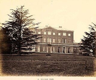
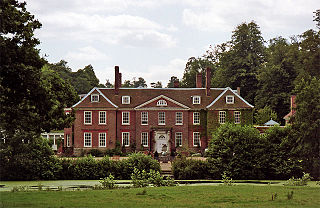
Binfield Park is an English country house. It is a historic Grade II* listed building. The house is located just northeast of Binfield, Berkshire.
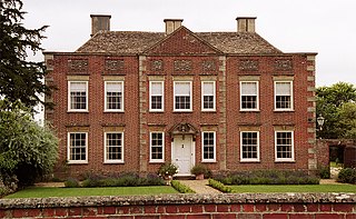
Binfield Lodge is an English country house. It is a historic Grade II* listed building. The house is located north of Binfield, Berkshire.

