
Walvis Bay is a city in Namibia and the name of the bay on which it lies. It is the second largest city in Namibia and the largest coastal city in the country. The city covers an area of 29 square kilometres (11 sq mi) of land. The bay is a safe haven for sea vessels because of its natural deep-water harbour, protected by the Pelican Point sand spit, being the only natural harbour of any size along the country's coast. Being rich in plankton and marine life, these waters also draw large numbers of southern right whales, attracting whalers and fishing vessels.

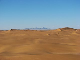
The Namib is a coastal desert in Southern Africa. According to the broadest definition, the Namib stretches for more than 2,000 kilometres (1,200 mi) along the Atlantic coasts of Angola, Namibia, and northwest South Africa, extending southward from the Carunjamba River in Angola, through Namibia and to the Olifants River in Western Cape, South Africa. The Namib's northernmost portion, which extends 450 kilometres (280 mi) from the Angola-Namibia border, is known as Moçâmedes Desert, while its southern portion approaches the neighboring Kalahari Desert. From the Atlantic coast eastward, the Namib gradually ascends in elevation, reaching up to 200 kilometres (120 mi) inland to the foot of the Great Escarpment. Annual precipitation ranges from 2 millimetres (0.079 in) in the aridest regions to 200 millimetres (7.9 in) at the escarpment, making the Namib the only true desert in southern Africa. Having endured arid or semi-arid conditions for roughly 55–80 million years, the Namib may be the oldest desert in the world and contains some of the world's driest regions, with only western South America's Atacama Desert to challenge it for age and aridity benchmarks.

The African penguin, also known as Cape penguin or South African penguin, is a species of penguin confined to southern African waters. Like all penguins, it is flightless, with a streamlined body and wings stiffened and flattened into flippers for a marine habitat. Adults weigh an average of 2.2–3.5 kg (4.9–7.7 lb) and are 60–70 cm (24–28 in) tall. The species has distinctive pink patches of skin above the eyes and a black facial mask. The body's upper parts are black and sharply delineated from the white underparts, which are spotted and marked with a black band.

Lüderitz is a town in the ǁKaras Region of southern Namibia. It lies on one of the least hospitable coasts in Africa. It is a port developed around Robert Harbour and Shark Island.

Sandboarding is a boardsport and extreme sport similar to snowboarding that involves riding across or down a sand dune while standing on a board, either with both feet strapped in or while standing loose, without bindings. Sandboarding can also be practised sitting down or lying on the belly or the back. It typically involves a sandboard, although it is also possible to use sleds, surfboards, a skateboard deck, or snowboards.

Swakopmund is a city on the coast of western Namibia, 352 km (219 mi) west of the Namibian capital Windhoek via the B2 main road. It is the capital of the Erongo administrative district. As of 2011, the town had 44,725 inhabitants and 196 km2 (76 sq mi) of land. In 2023, the population had increased to 75,921 people.
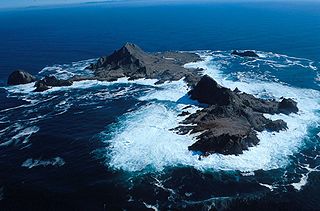
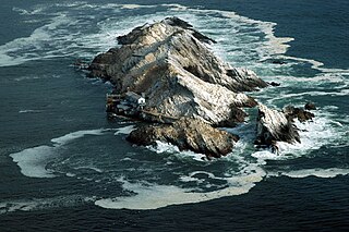
The Farallon Islands, or Farallones, are a group of islands and sea stacks in the Gulf of the Farallones, off the coast of San Francisco, California, United States. The islands are also sometimes referred to by mariners as the Devil's Teeth Islands, in reference to the many treacherous underwater shoals in their vicinity. The islands lie 30 miles (48 km) outside the Golden Gate and 20 miles (32 km) south of Point Reyes, and are visible from the mainland on clear days.The islands are part of the City and County of San Francisco. The only inhabited portion of the islands is on Southeast Farallon Island (SEFI), where researchers from Point Blue Conservation Science and the U.S. Fish and Wildlife Service stay. The islands are closed to the public.

The Penguin Islands are a historical group of mostly scattered islands and rocks situated along a stretch of 355 kilometres (221 mi) along the coastline of Namibia. Not forming a geographic whole, the Namibian government formally lists them as the Off-Shore islands. Their name comes from the presence of African penguins which inhabit the coastal region surrounding Namibia and South Africa.
Otjimbingwe is a settlement in the Erongo Region of central Namibia. Otjimbingwe has approximately 8,000 inhabitants and belongs to the Karibib electoral constituency.

TransNamib Holdings Limited, commonly referred to as TransNamib, is a state-owned railway company in Namibia. Organised as a holding company, it provides both rail and road freight services, as well as passenger rail services. Its headquarters are in the country’s capital Windhoek.
Sandwich Harbour, also known as Sandwich Bay, Sandvishawe, Sandvisbaai and Sandfisch Bai is an area on the Atlantic coast of Namibia that includes a bay in the north and a lagoon at the southern end. Sandwich Harbour might have been named after an English whaling ship, the Sandwich, which worked during the 1780s, or the name may be a corruption of the German word "sandfische", a species of shark found in the area. Formerly, the bay was a moderately-sized commercial port based around whaling and small-scale fishing, but it is now best known for its birdlife in the lagoon to the south of the bay.

Tourism in Namibia is a major industry, contributing N$7.2 billion to the country's gross domestic product. Annually, over one million travelers visit Namibia, with roughly one in three coming from South Africa, then Germany and finally the United Kingdom, Italy and France. The country is among the prime destinations in Africa and is known for ecotourism which features Namibia's extensive wildlife.
Mercury Island is a small rocky island off The Diamond Coast, Namibia. Despite its small size it is recognised by BirdLife International and other global conservation groups as an Important Bird Area (IBA) for its significant coastal seabird breeding.

The Wreck Reefs are located in the southern part of the Coral Sea Islands approximately 450 kilometres (280 mi) east-north-east of Gladstone, Queensland, Australia.
ENS (Edward Nathan Sonnenbergs) is Africa's largest law firm. ENS currently has over 620 practitioners and was established over 100 years ago. The firm specialises in all commercial areas of Law, Tax, Forensics and IP. The firm is a Level 2 Broad-Based Black Economic Empowerment (BBBEE) contributor. ENS is one of the traditional "Big Five" law firms in South Africa.
The Dorob National Park is a protected area in the Erongo region, along the central Namibian coast, gazetted as a national park under the Nature Conservation Ordinance No.4 of 1975 on 1 December 2010. It is 1,600 kilometres (990 mi) in length, and with Namib-Naukluft Park it covers an area of 107,540 square kilometres (41,520 sq mi).
The Swakopmund–Windhoek line was a main 600 mm narrow-gauge railway line in Namibia. It was built in 1897 and operated until 1990 when the route name was changed.

The Walvis Bay 2-4-2T Hope of 1899 was a South African steam locomotive from the pre-Union era in the Cape of Good Hope.

Ichaboe Island is a small rocky island off Namibia's Diamond Coast. It is recognised by BirdLife International as an Important Bird Area (IBAs) for its seabird breeding colonies.
The COVID-19 pandemic in Namibia is part of the worldwide pandemic of coronavirus disease 2019 caused by severe acute respiratory syndrome coronavirus 2. The Minister of Health and Social Services, Kalumbi Shangula, announced on 14 March 2020 that the virus had reached Namibia. A Romanian couple constituted the two first cases and recovered 79 days after their initial diagnosis.

