
Bury is a market town on the River Irwell in the Metropolitan Borough of Bury, Greater Manchester, England. which had a population of 81,101 in 2021 while the wider borough had a population of 193,846.

Bexley is an area of south-eastern Greater London, England and part of the London Borough of Bexley. It is sometimes known as Bexley Village or Old Bexley to differentiate the area from the wider borough. It is located 13 miles (21 km) east-southeast of Charing Cross and south of Bexleyheath.

Ashton-in-Makerfield is a market town in the Metropolitan Borough of Wigan, Greater Manchester, England, 4 miles (6.4 km) south of Wigan. As of the 2021 census, there was a population of 26,380.

Mossley (/ˈmɒzli/) is a town and civil parish in Tameside, Greater Manchester, England. It is located in the upper Tame Valley and the foothills of the Pennines, 3 miles (4.8 km) south-east of Oldham and 9 miles (14.5 km) east of Manchester.

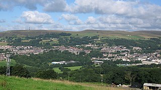
Rochdale is a town in Greater Manchester, England, and the administrative centre of the Metropolitan Borough of Rochdale. In the 2021 census the town had a population of 111,261, compared to 223,773 for the wider borough. Rochdale is in the foothills of the South Pennines and lies in the dale (valley) of the River Roch, 5 miles (8 km) northwest of Oldham, and 10 miles (16 km) northeast of Manchester.

Whitefield is a town in the Metropolitan Borough of Bury, Greater Manchester, England. It lies on undulating ground above the Irwell Valley, along the south bank of the River Irwell, 3 miles (4.8 km) southeast of Bury, and 5 miles (8.0 km) northwest of Manchester. Prestwich and the M60 motorway lie just to the south.
Cheadle Hulme is a suburb in the Metropolitan Borough of Stockport, Greater Manchester, England,. Historically in Cheshire, it is 2 miles (3.2 km) south-west of Stockport and 8 miles (12.9 km) south-east of Manchester. It lies in the Ladybrook Valley, on the Cheshire Plain, and the drift consists mostly of boulder clay, sands and gravels. In 2011, it had a population of 26,479.

Farnworth is a town in the Metropolitan Borough of Bolton, Greater Manchester, England, 2 miles (3.2 km) southeast of Bolton, 4 miles south-west of Bury (7 km), and 8 miles (12.9 km) northwest of Manchester.

Middleton is a town in the Metropolitan Borough of Rochdale, Greater Manchester, England, on the River Irk. It is 5 miles (8.0 km) southwest of Rochdale and 5 miles (8.0 km) northeast of Manchester. Middleton had a population of 42,972 at the 2011 Census. It lies on the northern edge of Manchester, with Blackley to the south and Moston to the south east.

Heywood is a town in the Metropolitan Borough of Rochdale, Greater Manchester, England, in the historic county of Lancashire. It had a population of 28,205 at the 2011 Census. The town lies on the south bank of the River Roch, 2 miles (3.2 km) east of Bury, 4 miles (6.4 km) southwest of Rochdale, and 8 miles (12.9 km) north of Manchester. Middleton lies to the south, whilst to the north is the Cheesden Valley, open moorland, and the Pennines. Heywood's nickname is Monkey Town.
Ramsbottom is a market town in the Metropolitan Borough of Bury, Greater Manchester, England. The population at the 2011 census was 17,872.

Prestwich is a town in the Metropolitan Borough of Bury, Greater Manchester, England, 3 miles (4.8 km) north of Manchester, 3 miles (5 km) north of Salford and 5 miles (8.0 km) south of Bury.

Radcliffe is a market town in the Metropolitan Borough of Bury, Greater Manchester, England. It lies in the Irwell Valley 7 miles (11 km) northwest of Manchester and 3 miles (5 km) southwest of Bury and is contiguous with Whitefield to the south. The disused Manchester Bolton & Bury Canal bisects the town.
Bury was a rural district in Lancashire, England from its establishment in 1894 under the Local Government Act 1894, until its abolition in 1933. The district consisted of a number of rural civil parishes near Bury, but did not include Bury itself. It was a successor to the Bury Rural Sanitary District.

Walmersley is a suburban village in the Metropolitan Borough of Bury, Greater Manchester, England.
Bamford is an affluent suburban area within the Metropolitan Borough of Rochdale, in Greater Manchester, England.

The historic parish of Bircle, near Bury, England, was created on 1 July 1846, although the village of Bircle has existed for many centuries. It is believed that 'Bircle' is a shortening of the phrase 'Birch Hill', as it was suggested that there were birch trees in the parish. Names such as "Cleggs Wood", "Simpson Clough" and "Dobb Wood" appear on early Ordnance Survey maps. "Hill' appeared in the fourteenth century in the name of 'Birkhill' but it never found a permanent place. Over time its name has also appeared as Brithull, 1243; Birlcil, 1246; Birkhill, 1334, 1573; but Bircle appears in the Diocese of Manchester directory in England.
Heap was a district of Bury, England until it was abolished in 1894 to become parts of the parishes of Heywood, Bury, Bircle and Unsworth.

St John the Baptist Church is a Roman Catholic Parish church in Rochdale, Greater Manchester, England. It was founded in 1830, and built in 1927. It is situated on the corner of Maclure Road and Dowling Street, opposite the Greater Manchester Fire Service Museum in the centre of the town. It was built in the Byzantine Revival style and is a Grade II* listed building.
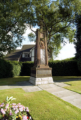
Heywood is a town in the Metropolitan Borough of Rochdale, Greater Manchester, England, and it is unparished. The town and the surrounding countryside contain 18 listed buildings that are recorded in the National Heritage List for England. Of these, two are listed at Grade II*, the middle grade, and the others are at Grade II, the lowest grade. Until the coming of the Industrial Revolution the area was rural, and during the 19th century cotton mills were built. The earliest listed buildings are a house and a farmhouse with farm buildings. The later listed buildings include cotton mills and a chimney, churches and associated structures, a railway warehouse, a library, a house designed by Edgar Wood, and two war memorials.

