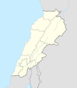
Lebanon, officially the Republic of Lebanon, is a country in the Levant region of West Asia. It is bordered by Syria to the north and east, by Israel to the south, and by the Mediterranean Sea to the west; Cyprus lies a short distance away from the country's coastline. Lebanon's location at the crossroads of the Mediterranean Basin and the Arabian hinterlands has contributed to the country's rich history and shaped a unique cultural identity denoted by religious diversity. Located in the Levant region of the Eastern Mediterranean, the country has a population of more than five million people and covers an area of 10,452 square kilometres (4,036 sq mi). Lebanon's capital and largest city is Beirut, followed by Tripoli and Jounieh. While Arabic is the official language, French is also recognized in a formal capacity; Lebanese Arabic is the country's vernacular, though French and English play a relatively significant role in everyday life, with Modern Standard Arabic being limited to news and government matters.
The Beqaa Valley, also transliterated as Bekaa, Biqâ, and Becaa and known in classical antiquity as Coele-Syria, is a fertile valley in eastern Lebanon. It is Lebanon's most important farming region. Industry also flourishes in Beqaa, especially that related to agriculture.
Southern Lebanon is the area of Lebanon comprising the South Governorate and the Nabatiye Governorate. The two entities were divided from the same province in the early 1990s. The Rashaya and Western Beqaa Districts, the southernmost districts of the Beqaa Governorate, in Southern Lebanon are sometimes included.

The 2006 Lebanon War, also called the 2006 Israel–Hezbollah War and known in Lebanon as the July War and in Israel as the Second Lebanon War, was a 34-day military conflict in Lebanon, northern Israel and the Golan Heights. The principal parties were Hezbollah paramilitary forces and the Israel Defense Forces (IDF). The conflict started on 12 July 2006, and continued until a United Nations-brokered ceasefire went into effect in the morning on 14 August 2006, though it formally ended on 8 September 2006 when Israel lifted its naval blockade of Lebanon. Due to unprecedented Iranian military support to Hezbollah before and during the war, some consider it the first round of the Iran–Israel proxy conflict, rather than a continuation of the Arab–Israeli conflict.

Al-Malikiyya was a Palestinian village located in the Jabal Amil region. In a 1920s census, the village was registered as part of Greater Lebanon. It was later placed under the British Mandate of Palestine. Its population was mostly Metawali Shiite.

Ghajar, also Rhadjar, is an Alawite-Arab village on the Hasbani River, on the border between Lebanon and the Israeli-occupied portion of the Golan Heights. In 2022, it had a population of 2,806.

Hunin was a Palestinian Arab village in the Galilee Panhandle part of Mandatory Palestine close to the Lebanese border. It was the second largest village in the district of Safed, but was depopulated in 1948. The inhabitants of this village were, similar to the inhabitants of Southern Lebanon, Shia Muslims.

The Jezzine District is a district in the South Governorate of Lebanon. The capital is Jezzine.

Henri Jibrayel is a French politician with Lebanese and Assyrian roots.

The Lebanon Mountain Trail is a long-distance hiking trail in Lebanon. It extends from Andaket in north of Lebanon to Marjayoun in the south along a 470 km (290 mi) path that transects more than 76 towns and villages at altitudes ranging from 570 to 2,073 meters above sea level.
Aray (عاريه) is a mountainous village in Jezzine, Lebanon.

Tannourine is a Lebanese town located in the Batroun District, part of the Governorate of North Lebanon, 80 km from the capital Beirut. Tannourine is formed by a cluster of mountain settlements located in the highs of the Batroun District, the largest of which is Tannourine El-Fawqa, followed by Chatine,Tannourine El-Tahta, and Wata Houb. Tannourine has a population of approximately 25,000.
Kassin is a surname. Notable people with the surname include:
George Alexander Doumani was a Lebanese Palestinian geologist and explorer.

Kaukaba, Kaukabet El-Arab or Kaukaba Station is a village in the Hasbaya District in the Nabatiye Governorate in southern Lebanon.
The Lebanese–Syrian border clashes were a series of clashes on the Lebanon–Syria border caused by the ongoing Syrian Civil War.

The Qalamoun offensive (2014) was launched by the Syrian Army, in coordination with the Lebanese militia Hezbollah, during the Syrian Civil War against remnant rebel forces following the previous Battle of Qalamoun which resulted in the military securing all of the towns in the region.
Kouachra is a village in Akkar Governorate, Lebanon. It is located approximately 131 kilometres (81 mi) north of Beirut and 38 kilometres (24 mi) north of Tripoli.
The Rangers Sports Events are sports events organized yearly in Lebanon by the Rangers Regiment of the Lebanese army. The events aim to explore Lebanon's mountains and beauty, promote Lebanon's touristic image by making the events as International on yearly basis and to empower the Military-Civilian interaction.