Blaauboschkraal stone ruins

Last updated

Blaauboshkraal Stone Ruins
Bauwboschkraal Stone Ruins 30-April 2023.jpg
South Africa Mpumalanga location map.svg
Archaeological site icon (red).svg
Shown within Mpumalanga
South Africa adm location map.svg
Archaeological site icon (red).svg
Blaauboschkraal stone ruins (South Africa)
Location South Africa
Region Mpumalanga
Coordinates 25°35′41″S30°17′20″E / 25.5947°S 30.2888°E / -25.5947; 30.2888
Type Stone Wall used for agricultural Terracing and as a kraal [1]
Part of Bokoni
Length≈50m
Width≈50m
Height≈1-2m [1]
History
Founded≈ 16th Century [1]
Periods Late Iron Age
Cultures Bokoni
Associated with Bokoni
Site notes
ConditionSurface artefact visibility moderate due natural erosional exposure.
Public accessYes

The Blaauboschkraal stone ruins are a provincial heritage site in the Mpumalanga province of South Africa. Its neighbouring town, Emgweyna, is 10 kilometres away. The site was declared a national monument on 18 April 1975 [2] and is a heritage site recognised by the South African Heritage Resources Agency.

Contents

Bokoni Stone Ruins Bokoni Stone Ruins.jpg
Bokoni Stone Ruins
Bauwboschkraal Stone Ruins 30 April 2023 Bauwboschkraal Stone Ruins 30-April 2023.jpg
Bauwboschkraal Stone Ruins 30 April 2023

The Blaauboschkraal stone ruins make up what was part of a large, complex stone walling system built by the Bokoni people. While the exact age of the Blaauboschkraal stone sites is unknown the Bokoni people are estimated to have built stone walled settlements around the early 16th century. The site is assumed to have been used for cattle enclosures, agricultural terracing, and housing for the Bokoni people. This has been hypothesised due to the circular shaping of stone walling that characterises this site. [3]

Location

The Blaauboschkraal Stone Ruins are located in the Mpumalanga escarpment. In this region there is a clustering of stone walled settlements which span for 10,000 square kilometres, approximately 150 kilometres long north to south and around 50 km east to west. [4] This area is estimated to have once been occupied by the Bokoni people who built these settlements. The Bokoni settlements are characterised by cattle paths linking roughly circular homesteads throughout spreads of agricultural terraces. [5] The Bokoni people are estimated to have settled the region from a period between the 16th to the early 19th century. [5] The Blaauboschkraal stone ruins make up part of the clusters in this region.

The Blaauboschkraal ruins are located on a steep sided valley where the Blouboskraalspruit river flows. The Blouboskraalspruit River is a tributary of the Crocodile River which flows to the Rio Incomati River. It is thought that this river system was one of the many used for Bokoni to trade with the rest of the world at the time. It is estimated they traded primarily agricultural products and formed part of the Zimbabwe-Portuguese trade route. It is thought then that the location of the Blaauboschkraal stone ruins was influenced by its location to water which facilitated trade. [1]

Historical context

The Blaauboschkraal stone ruins are widely understood to have been built and used by the Bokoni people [1] and date somewhere within the last 500 years. [6]

As characterised through the ‘phases’ of the Bokoni civilisation it is assumed the Blaauboschkraal stone ruins were built in the third phase. The third phase describes the time where there was increasing threat of domination from outside invaders on the Bokoni people. Because of invaders, propelled by the Mfecane, the Bokoni built ‘refugee’ settlements in kloofs (steep sided wooded valleys) instead of their traditional open-valley homesteads (Bokoni settlements primarily built-in stages one and two of Bokoni civilisation). Building settlements hidden away in valleys increased the Bokoni defense and created refuge for those living in them. [1]

Considering the Blaauboschkraal stone ruins are located on a hillside of a valley, it is assumed this settlement was built in the 3rd stage of Bokoni civilisation. [7]

The Blaauboschkraal Stone ruins are isolated away from other stone walled settlements found. It is more common for open-valley homesteads to have a complex connectedness between settlements which is seen in the region. This is thought to be a result not only of the 3rd phase of civilisation but also because of the weak political regime the Bokoni are thought to have had. The stone ruins found in the Mpumalanga region mirror a decentralised civilisation inferencing that they also had decentralised political and military systems. The Bokoni are thought to have been more influenced by trade than defense and military and this is what is assumed to explain the location of settlements discovered. [1]

The trade route which was the Bokoni contributed to was that of the Late Iron Age. The landscape in which the Bokoni domesticated facilitated intensive agricultural production instead of copper and iron production which was popular in surrounding regions. This meant that they could generate food products in return for other necessities and luxuries such as metal and ivory. It is also estimated that their intensive food production may have provided the food security needed by those surrounding regions. [4]

Archaeology

Description

The stone walls in the Mpumalanga region and specifically the Blaauboschkraal ruins are built in a uniform structure and made from stone local to the region. The outer structure is built through larger stone and inside filled with smaller stones. Flat slabs of rock are placed on top of these structures to create stronger walls. [8]

While the exact height of the Blaauboschkraal stone ruins is unknown, on average the stone walls in the Mpumalanga region are 1.2 meters tall and the least damaged parts reaching 2 metres tall. [1]

Use

The inner circular structures of this site is thought to have been the homestead for the settlement [9] and the more complex walling around the central homestead is assumed to have been used as a kraal (enclosures for cattle) by the Bokoni people. [3] It is thought the Bokoni people used kraals to create pastures for livestock and prevent them from grazing on crops. [2] The livestock they contained are thought to be cattle, sheep, goats and chickens. [2]

The structure of this site features agricultural terracing. During the period of the Bokoni average rainfall in the region is estimated to have been around 660-1000mm per annum. [4] This high rainfall makes it likely to assume terracing was effective in retaining and distributing moisture and maximising agricultural production. Terracing is also effective in protecting against erosion and to retain high-quality soils of the region. Therefore intensive agricultural production occurred on these sites, even ones located on steep valleys such as the Blaauboschkraal stone settlement. [8]

By the 1830s the Bokoni homesteads and terraces were abandoned. This destruction of the Bokoni was propelled by the Mfecane. This is also the estimated time the Blaauboschkraal ruins were abandoned. [4]

Research

Bokoni sites have been studied from the 1930s. Until recent, around 30 years ago, archaeologists studying sites specialised in understanding the key characteristics of these sites. Now, archaeologists have become interested in developing a deeper understanding of the cultural importance of these sites and the way the Bokoni influenced the evolution of Southern Africa and the Late Iron Age. However there is limited research that has been done on these sites and many questions remain. [4]

The Blaauboschkraal ruins therefore still holds questions to its exact use, why it exists and exactly what it used to look like.

Alternate theories

Pseudoarchaeological alternative explanations have been put forward for the Blaauboschkraal stone ruins, attributing alien and/or ancient origins. The most prominent proponent is Michael Tellinger, a politician whom Hammer and Swartz characterise as a promoter of conspiracy theories, influenced by Zecharia Sitchin's ideas of ancient astronauts. [10] He calls the site "Adam's Calendar", and claims it is the remains of an alien-made construction built about 300,000 years ago as an ancient calendar. [10] [11] [12] Tellinger theory is based on the alignments of the stones with the stars. The stones would have been aligned with the constellation of Orion in the position in which it would have appeared in that distant era. [13]

Conservation

Heritage Management

The Blaauboschkraal ruins are listed as a provincial heritage site by the South African Heritage Resources Agency. Along with the provincial heritage resources authorities, the site is protected under the National Heritage Resources Act, Act 25 of 1999. This helps to maintain the quality of the site today.

Threats

The stone ruins of the Bokoni civilisation face threats to their conservation. Primarily weather has affected the quality of these stone ruins; this may include erosion from wind etc. These effects have been seen as the average size of Bokoni stone walls are 1.2 metres high, but some are 2 metres high indicating the effect of the weather.

The Blaauboschkraal stone ruins are a heritage listed site which aids in maintaining the quality of the ruins. Peter Delius, a historian and archaeologist, stresses however that the leadership in governance over the Mpumalanga province is not doing enough to maintain integrity of the sites. “As a matter of urgency, an audit of the sites needs to be done. It should be made clear that any person tampering with, removing objects, or vandalising the sites is committing a crime and will be prosecuted,” Delius said. [14]

See also

Related Research Articles

<span class="mw-page-title-main">Harappa</span> Archaeological site in Punjab, Pakistan

Harappa is an archaeological site in Pakistan, about 25 km (16 mi) north of Sahiwal. The Bronze Age Harappan civilisation, now more often called the Indus Valley Civilisation, is named after the site, which takes its name from a modern village near the former course of the Ravi River, which now runs 8 km (5.0 mi) to the north. The core of the Harappan civilisation extended over a large area, from Gujarat in the south, across Sindh and Rajasthan and extending into Punjab and Haryana. Numerous sites have been found outside the core area, including some as far east as Uttar Pradesh and as far west as Sutkagen-dor on the Makran coast of Balochistan, not far from Iran.

<span class="mw-page-title-main">Great Zimbabwe</span> Ruins of a medieval city in southeast Zimbabwe

Great Zimbabwe is a medieval city in the south-eastern hills of the modern country of Zimbabwe, near Lake Mutirikwe and the town of Masvingo. It is thought to have been the capital of a kingdom during the Late Iron Age. Construction on the city began in the 11th century and continued until it was abandoned in the 15th century. The edifices were erected by ancestors of the Shona people, currently located in Zimbabwe and nearby countries. The stone city spans an area of 7.22 square kilometres (2.79 sq mi) and could have housed up to 18,000 people at its peak, giving it a population density of approximately 2,500 inhabitants per square kilometre (6,500/sq mi). It is recognised as a World Heritage Site by UNESCO.

<span class="mw-page-title-main">Drakensberg</span> Mountain range in South Africa

The Drakensberg is the eastern portion of the Great Escarpment, which encloses the central Southern African plateau. The Great Escarpment reaches its greatest elevation – 2,000 to 3,482 metres within the border region of South Africa and Lesotho.

<span class="mw-page-title-main">Mpumalanga</span> Province in South Africa

Mpumalanga is a province of South Africa. The name means "East", or literally "The Place Where the Sun Rises" in the Nguni languages. Mpumalanga lies in eastern South Africa, bordering Eswatini and Mozambique. It shares borders with the South African provinces of Limpopo to the north, Gauteng to the west, the Free State to the southwest, and KwaZulu-Natal to the south. The capital is Mbombela.

<span class="mw-page-title-main">Terrace (earthworks)</span> Terrain formed by tiered platforms

In agriculture, a terrace is a piece of sloped plane that has been cut into a series of successively receding flat surfaces or platforms, which resemble steps, for the purposes of more effective farming. This type of landscaping is therefore called terracing. Graduated terrace steps are commonly used to farm on hilly or mountainous terrain. Terraced fields decrease both erosion and surface runoff, and may be used to support growing crops that require irrigation, such as rice. The Rice Terraces of the Philippine Cordilleras have been designated as a UNESCO World Heritage Site because of the significance of this technique.

<span class="mw-page-title-main">Khami</span> Ruined city and capital of the Kingdom of Butua

Khami is a ruined city located 22 kilometres (14 mi) west of Bulawayo, in Zimbabwe. It was once the capital of the Kingdom of Butua of the Torwa dynasty. It is now a national monument and became a UNESCO World Heritage Site in 1986.

<span class="mw-page-title-main">Ollantaytambo</span> Archaeological site in Peru

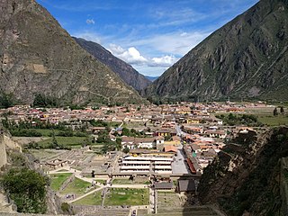
Ollantaytambo is a town and an Inca archaeological site in southern Peru some 72 km (45 mi) by road northwest of the city of Cusco. It is located at an altitude of 2,792 m (9,160 ft) above sea level in the district of Ollantaytambo, province of Urubamba, Cusco region. During the Inca Empire, Ollantaytambo was the royal estate of Emperor Pachacuti, who conquered the region, and built the town and a ceremonial center. At the time of the Spanish conquest of Peru, it served as a stronghold for Manco Inca Yupanqui, leader of the Inca resistance. Located in the Sacred Valley of the Incas, it is now an important tourist attraction on account of its Inca ruins and its location en route to one of the most common starting points for the four-day, three-night hike known as the Inca Trail.

<span class="mw-page-title-main">Machadodorp</span> Place in Mpumalanga, South Africa

Machadodorp, also known by its official name eNtokozweni, is a small town situated on the N4 road, near the edge of the escarpment in the Mpumalanga province, South Africa. The Elands River runs through the town. There is a natural radioactive spring here that is reputed to have powerful healing qualities.

<span class="mw-page-title-main">White River, Mpumalanga</span> Place in Mpumalanga, South Africa

White River is a small holiday and farming town situated just north of Mbombela in Mpumalanga, South Africa. The farms in the region produce tropical fruits, macadamia nuts, vegetables, flowers and timber. As of 2011, White River had a population of 16,639.

<span class="mw-page-title-main">Rhine Gorge</span> UNESCO World Heritage Site in Rheinland Pfalz and Hessen in Germany

The Rhine Gorge is a popular name for the Upper Middle Rhine Valley, a 65 km section of the Rhine between Koblenz and Rüdesheim in the states of Rhineland-Palatinate and Hesse in Germany. It was added to the UNESCO list of World Heritage Sites in June 2002 because of its beauty as a cultural landscape, its importance as a route of transport across Europe, and the unique adaptations of the buildings and terraces to the steep slopes of the gorge.

The Kingdom of Mapungubwe was a medieval state in South Africa located at the confluence of the Shashe and Limpopo rivers, south of Great Zimbabwe. The name is derived from either TjiKalanga and Tshivenda. The name might mean "Hill of Jackals" or "stone monuments". The kingdom was the first stage in a development that would culminate in the creation of the Kingdom of Zimbabwe in the 13th century, and with gold trading links to Rhapta and Kilwa Kisiwani on the African east coast. The Kingdom of Mapungubwe lasted about 140 years, and at its height the capital's population was about 5000 people.

<span class="mw-page-title-main">Dholavira</span> Indus Valley Civilization site in Gujarat, India

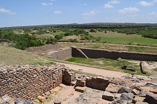
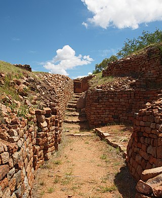
Dholavira is an archaeological site at Khadirbet in Bhachau Taluka of Kutch District, in the state of Gujarat in western India, which has taken its name from a modern-day village 1 kilometre (0.62 mi) south of it. This village is 165 km (103 mi) from Radhanpur. Also known locally as Kotada timba, the site contains ruins of a city of the ancient Indus Valley civilization. Earthquakes have repeatedly affected Dholavira, including a particularly severe one around 2600 BCE.

<span class="mw-page-title-main">Sukur</span> UNESCO World Heritage Site in Madagali, Nigeria

Sukur or Sukur Cultural Landscape is a UNESCO World Heritage Site located on a hill above the village of Sukur in the Adamawa State of Nigeria. It is situated in the Mandara Mountains, close to the border with Cameroon. Its UNESCO inscription is based on the cultural heritage, material culture, and the naturally-terraced fields. Sukur is Africa's first cultural landscape to receive World Heritage List inscription.

<span class="mw-page-title-main">Engaruka</span> National Historic Site of Tanzania

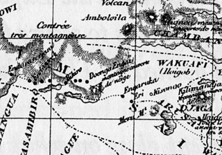
Engaruka is an abandoned system of ruins located in northwest Monduli District in central Arusha Region. The site is in geographical range of the Great Rift Valley of northern Tanzania. Situated in the Monduli District, it is famed for its irrigation and cultivation structures. It is considered one of the most important Iron Age archaeological sites in Tanzania. The site is located in the ward of Engaruka. The site is registered as one of the National Historic Sites of Tanzania.

<span class="mw-page-title-main">Ziwa</span> Archaeological site in Zimbabwe

Ziwa is an archaeological site in Nyanga District, Zimbabwe, containing the remains of a vast late Iron Age agricultural settlement dated to the 15th century. It is one of many sites that compose the Nyanga Iron Age ruins. Ziwa was declared a National Monument in 1946 and is currently under consideration for World Heritage listing. The site contains a large variety of stonework structures including stone terraces running along contours of hills and steep landscapes. Archaeological investigations have also uncovered important aspects of pottery and rock art.

The Dzata Ruins, an archaeological site in Dzanani in the Makhado municipality, Vhembe district, in the north of South Africa, is one of the national monuments in South Africa.

<span class="mw-page-title-main">Thimlich Ohinga</span> National Monument of Kenya

Thimlich Ohinga is a complex of stone-built ruins in Migori county, Nyanza Kenya, in East Africa. It is the largest one of 138 sites containing 521 stone structures that were built around the Lake Victoria region in Kenya. These sites are highly clustered. The main enclosure of Thimlich Ohinga has walls that are 1–3 m (3.3–9.8 ft) in thickness, and 1–4.2 m (3.3–13.8 ft) in height. The structures were built from undressed blocks, rocks, and stones set in place without mortar. The densely packed stones interlock. The site is believed to date to the 15th century or earlier.

The architecture of Zimbabwe is composed of three architectural types: the Hill Complex, the Valley Complex, and the Great Enclosure. Both traditional and colonial architectures have influenced the history and culture of the country. However, post-1954 buildings are mainly inspired by pre-colonial, traditional architecture, especially Great Zimbabwe–inspired structures such as the Kingdom Hotel, Harare international airport, and the National Heroes' Acre.

Bokoni was a pre-colonial, agro-pastoral society found in northwestern and southern parts of present-day Mpumalanga province, South Africa. Iconic to this area are stone-walled sites, found in a variety of shapes and forms. Bokoni sites also exhibit specialized farming and long-distance trading with other groups in surrounding regions. Bokoni saw occupation in varying forms between approximately 1500 and 1820 A.D.

Kweneng’ ruins are the remains of a pre-colonial Tswana capital occupied from the 15th to the 19th century AD in South Africa. The site is located 30km south of the modern-day city of Johannesburg. Settlement at the site likely began around the 1400s and saw its peak in the 15th century. The Kweneng' ruins are similar to those built by other early civilizations found in the southern Africa region during this period, including the Luba–Lunda kingdom, Kingdom of Mutapa, Bokoni, and many others, as these groups share ancestry. Kweneng' was the largest of several sizable settlements inhabited by Tswana speakers prior to European arrival. Several circular stone walled family compounds are spread out over an area 10km long and 2km wide. It is likely that Kweneng' was abandoned in the 1820s during the period of colonial expansion-related civil wars known as the Mfecane or Difaqane, leading to the dispersal of its inhabitants.

References

Footnotes

  1. 1 2 3 4 5 6 7 8 Delius, P.; Maggs, T.; Schoeman, M. (2012). "Bokoni: Old Structures, New Paradigms? Rethinking Pre-colonial Society from the Perspective of the Stone-Walled Sites in Mpumalanga". Journal of Southern African Studies . 38 (2): 399–414. doi:10.1080/03057070.2012.682841. JSTOR   23266579. S2CID   145467790.
  2. 1 2 3 Klerk, W. A. (2019). Bokoni of Mpumalanga. Pretoria: University of South Africa
  3. 1 2 Huffman, T. N. (2017, August 11). Prehistory of the Nelspruit area. Retrieved from South African History Online : https://www.sahistory.org.za/article/prehistory-nelspruit-area
  4. 1 2 3 4 5 Delius, P.; Schirmer, S. (2014). "ORDER, OPENNESS, AND ECONOMIC CHANGE IN PRECOLONIAL SOUTHERN AFRICA: A PERSPECTIVE FROM THE BOKONI TERRACES". The Journal of African History . 55 (1): 37–54. doi:10.1017/S0021853713000844. JSTOR   43305158. S2CID   154963348.
  5. 1 2 Delius, P., Maggs, T., & Schoeman, A. (2014). Forgotten World: The Stone Walled Settlements of the Mpumalanga Escarpment. Johannesburg : Wits University Press .
  6. Widgren, M.; , T. Maggs; Anna Plikk; J. Risberg; M. Schoeman & Lars-Ove Westerberg (2016). "Precolonial Agricultural Terracing in Bokoni, South Africa: Typology and an Exploratory Excavation". Journal of African Archaeology . 14 (1): 33–53. doi:10.3213/2191-5784-10281. JSTOR   44296868. S2CID   53334568.
  7. Schoeman, A. (2008). Revisiting Bokoni: Populating the Stone Ruins of the Mpumalanga Escarpment. In N. Esterhuysen, P. Bonner, & N. Swanepoel, Five hundred years rediscovered: Southern African precedents and prospects (pp. 135-168). Johannesburg : Wits University Press.
  8. 1 2 Terri, E. (Director). (2015). Forgotten World [Motion Picture].
  9. Evers, T. M (1975). "Recent Iron Age Research in the Eastern Transvaal, South Africa". The South African Archaeological Bulletin. 30 (119/120): 71–83. doi:10.2307/3888096. JSTOR   3888096. S2CID   150297215.
  10. 1 2 Hammer, Olav; Swartz, Karen (May 2020). "Field Notes: The Bosnian Pyramid Phenomenon" (PDF). Nova Religio . 23 (4): 94–110.
  11. Moore, A. (27 June 2014). "6 Ancient African Architectural Marvels Built Before Greece or Rome Existed". Atlanta Black Star.
  12. Alfreds, Duncan (9 March 2011). "Human genesis is alien SA author". News24.
  13. "Adam's calendar: evidence of a 200,000-year-old civilization? • Neperos". Neperos.com.
  14. Yende, S. s. (2017, September 17). Heritage under threat. Retrieved from news24: https://web.archive.org/web/20190227215149/http://www.news24.com/SouthAfrica/News/heritage-under-threat-20170916

Further reading