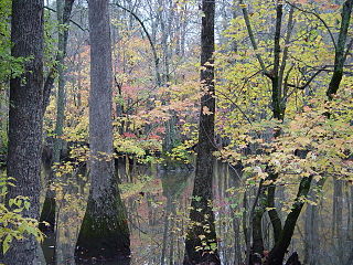
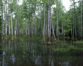
The Cache River National Wildlife Refuge is a 68,993 acre (223 km2) (2014) wildlife refuge in the state of Arkansas managed by the United States Fish and Wildlife Service (FWS). The refuge is one of the Ramsar wetlands of international importance under the Ramsar Convention signed in 1971. It is one of the most important wintering area for ducks and the largest remaining tract of contiguous bottomland hardwood forest on the North American continent. In 2005, a possible sighting of the ivory-billed woodpecker, thought to be extinct, brought attention to the refuge.

The Bald Knob National Wildlife Refuge is a 15,022 acres (60.79 km2) (2014) wildlife refuge located in White County, Arkansas about two miles south of the town of Bald Knob. The refuge is managed by the United States Fish and Wildlife Service. The refuge features large numbers of migratory waterfowl and bald eagles during the winter months.

The Piney Woods is a temperate coniferous forest terrestrial ecoregion in the Southern United States covering 54,400 square miles (141,000 km2) of East Texas, southern Arkansas, western Louisiana, and southeastern Oklahoma. These coniferous forests are dominated by several species of pine as well as hardwoods including hickory and oak. Historically the most dense part of this forest region was the Big Thicket though the lumber industry dramatically reduced the forest concentration in this area and throughout the Piney Woods during the 19th and 20th centuries. The World Wide Fund for Nature considers the Piney Woods to be one of the critically endangered ecoregions of the United States. The United States Environmental Protection Agency (EPA) defines most of this ecoregion as the South Central Plains.

Marais des Cygnes National Wildlife Refuge (NWR) is located in Linn County, Kansas along the Marais des Cygnes River. The 7,500 acre (30 km2) Refuge was established in 1992 to protect one of the northwesternmost examples of bottomland hardwood forest in the United States as well as the largest contiguous tract of bottomland hardwood forest in Kansas.
The Wheeler National Wildlife Refuge is a 35,000-acre (142 km2) national wildlife refuge (NWR) located along the Tennessee River near Decatur, Alabama. Named after Major General Joseph Wheeler, it was established to provide a habitat for wintering and migrating birds in the Eastern United States.
The Yazoo National Wildlife Refuge is a 12,941 acre (52.4 km2) National Wildlife Refuge located in Washington County, Mississippi. Named after the Yazoo tribe, it was established to provide waterfowl and other migratory birds in the Mississippi Flyway with nesting, feeding, brooding, and resting habitat.

The Rachel Carson National Wildlife Refuge is a 9,125-acre (37 km2) National Wildlife Refuge made up of several parcels of land along 50 miles (80 km) of Maine's southern coast. Created in 1966, it is named for environmentalist and author Rachel Carson, whose book Silent Spring raised public awareness of the effects of DDT on migratory songbirds, and of other environmental issues.
The Atchafalaya National Wildlife Refuge is located about 30 miles (48 km) west of Baton Rouge, Louisiana, and one mile (1.6 km) east of Krotz Springs, Louisiana, lies just east of the Atchafalaya River. In 1988 under the administration of Governor Foster the "Atchafalaya Basin Master Plan" was implemented that combined the 11,780-acre (4,770 ha) Sherburne Wildlife Management Area (WMA), the 15,220-acre (6,160 ha) Atchafalaya National Wildlife Refuge, and the 17,000-acre (6,900 ha) U.S. Army Corps of Engineers' Bayou Des Ourses into the Sherburne Complex Wildlife Management Area.

Bayou Teche National Wildlife Refuge is located in the coastal towns of Franklin, Garden City and Centerville on Bayou Teche in St. Mary Parish, Louisiana, United States. The 9,028-acre (36.54 km2) refuge is forested with bottomland hardwoods and cypress-gum forests. The refuge was established in St. Mary Parish in 2001. The surrounding area includes oil and gas wells and canals.
D'Arbonne National Wildlife Refuge is a National Wildlife Refuge of the United States located north of West Monroe, Louisiana. It is in Ouachita and Union Parishes on either side of Bayou D'Arbonne near its confluence with the Ouachita River. It lies on the western edge of the Mississippi River alluvial valley. It was established in 1975 to protect bottomland hardwoods and provide wintering habitat for migratory waterfowl. D'Arbonne is one of four refuges managed in the North Louisiana Refuges Complex.
Handy Brake National Wildlife Refuge is located just north of Bastrop, Louisiana in Morehouse Parish, north central Louisiana. The refuge was established in 1988 with the southeast's first fee title transfer of a Farmer's Home Administration tract to the U.S. Fish and Wildlife Service. A free lease of 38 acres (150,000 m2) from International Paper increased the refuge to the current 501 acres (2.03 km2).
Lake Ophelia National Wildlife Refuge was established in 1988 to protect the Mississippi/Red River floodplain ecosystem. The refuge is located in Avoyelles Parish, Louisiana, east central Louisiana. The refuge is named for its most prominent water body, the 350-acre (1.4 km2) Lake Ophelia that was at one time a channel of the nearby Red River of the South.
Upper Ouachita National Wildlife Refuge was established in 1978 and is located in Union and Morehouse Parishes in northern Louisiana.

Pine Island Bayou is a tributary of the Neches River located in southeast Texas. It runs about 55 miles from the northwest corner of Hardin County, Texas and flows in a southeastern direction through western Hardin County, turning east and defining the southern Hardin and Jefferson County boundary for about 20 miles until its confluence with the Neches River. Two significant tributaries of Pine Island Bayou are Mayhaw Creek and Little Pine Island Bayou. The lower ten miles of Pine Island Bayou and much of Little Pine Island Bayou are protected from development in the Big Thicket National Preserve. Excluding the last few miles north of Beaumont, the area is not densely populated, and some small towns include Sour Lake and Saratoga, the latter the birthplace of country singer George Jones.
Bond Swamp National Wildlife Refuge, located 6 miles south of Macon, Georgia, United States, was established in 1989 to protect, maintain and enhance the forested wetland ecosystem of the Ocmulgee River floodplain. It opened to the public in 2000 and consists of 8,600 acres situated along the fall line separating the Piedmont and Coastal Plains. The acquisition boundary established in 1999 includes around 17,000 acres, though the Fish and Wildlife service has been unable to acquire much private land. The refuge has a diversity of vegetation communities, including mixed hardwood-pine, bottomland hardwoods, tupelo gum swamp forests, creeks, tributaries, beaver swamps and oxbow lakes. The refuge is rich in wildlife diversity including white-tailed deer, wood ducks, black bears, alligators, wild turkey, a nesting pair of bald eagles and excellent wintering habitat for waterfowl. Extensive bottomland hardwoods provide critical habitat for neotropical songbirds of concern, such as Swainson's warbler, wood thrush, prothonotary warbler and yellow-billed cuckoo. The combination of warm weather and wet areas at Bond Swamp provide ideal conditions for a variety of reptile and amphibian species.

Mackay Island National Wildlife Refuge was established in 1960 to provide habitat for migratory waterfowl, primarily the greater snow goose. It is located almost entirely on Knotts Island in the Currituck Sound between Back Bay in Virginia Beach, Virginia and the open sound in North Carolina. Most of the refuge lies within North Carolina but some of it is in Virginia. The refuge is primarily made up of marsh habitat. This area has long been recognized for supporting significant migratory waterfowl populations and sport fishery resources, and is part of the Charles Kuralt Trail.

The Middle Atlantic coastal forests are a temperate coniferous forest mixed with patches of evergreen broadleaved forests along the coast of the southeastern United States.

The fauna of Louisiana is characterized by the region's low swamplands, bayous, creeks, woodlands, coastal marshlands and beaches, and barrier islands covering an estimated 20,000 square miles, corresponding to 40 percent of Louisiana's total land area. Southern Louisiana contains up to fifty percent of the wetlands found in the Continental United States, and are made up of countless bayous and creeks.
The Mississippi Alluvial Plain is a Level III ecoregion designated by the Environmental Protection Agency (EPA) in seven U.S. states, though predominantly in Arkansas, Louisiana, and Mississippi. It parallels the Mississippi River from the Midwestern United States to the Gulf of Mexico.

The Arkansas Valley is a Level III ecoregion designated by the Environmental Protection Agency (EPA) in the U.S. states of Arkansas and Oklahoma. It parallels the Arkansas River between the flat plains of western Oklahoma and the Arkansas Delta, dividing the Ozarks and the Ouachita Mountains with the broad valleys created by the river's floodplain, occasionally interrupted by low hills, scattered ridges, and mountains. In Arkansas, the region is often known as the Arkansas River Valley, especially when describing the history and culture of the region.


