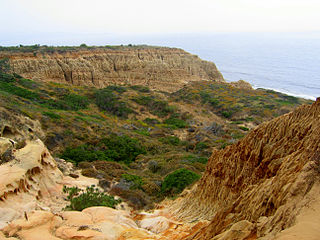
Torrey Pines State Natural Reserve is 2,000 acres (810 ha) of coastal state park located in the community of La Jolla, in San Diego, California, off North Torrey Pines Road. Although it is located within San Diego city limits, it remains one of the wildest stretches of land (8 km²) on the Southern California coast. It is bordered immediately on the south by Torrey Pines Municipal Golf Course and on the north by the city of Del Mar. The reserve was designated a National Natural Landmark in 1977.

Tierrasanta, Spanish for "holy land," or "holy ground", is a community within the city of San Diego, California. The symbol of Tierrasanta is an encircled Conquistador cross, similar to one atop Montserrat (mountain) near Barcelona, Spain, though it no longer holds any religious meaning. The community is referred to as "The Island in the Hills" by locals and on welcome signs, as there are only four roads that lead to Tierrasanta, all which end within the community.

The Cleveland National Forest encompasses 460,000 acres/720 sq mi (1,900 km2) of inland montane regions—approx. 60 miles from the Pacific Ocean—within the counties of San Diego, Riverside, and Orange, California. The landscape varies somewhat, with mostly chaparral canyons, arroyos and high desert, but dotted with meadows and oak and conifer forests. Near water sources, riparian environments and perennial aquatic plants attract native and migratory wildlife, such as at San Diego’s man-made Lake Cuyamaca. A generally warm and dry, inland-Mediterranean climate prevails over the forest, with the cooler months producing morning frost and snowfall. It is the southernmost U.S. National Forest of California. The area is administered by the U.S. Forest Service, a government agency within the United States Department of Agriculture, and is locally overseen by the Descanso, Palomar and Trabuco Ranger Districts.

Topanga State Park is a California state park located in the Santa Monica Mountains, within Los Angeles County, California. It is part of the Santa Monica Mountains National Recreation Area.

Cuyamaca Rancho State Park is a state park in Southern California, United States, located 40 miles (64 km) east of San Diego in the Cuyamaca and Laguna Mountains of the Peninsular Ranges. The park's 26,000 acres (11,000 ha) feature pine, fir, and oak forests, with meadows and streams that exist due to the relatively high elevation of the area compared to its surroundings. The park includes 6,512-foot (1,985 m) Cuyamaca Peak, the second-highest point in San Diego County.

Rancho Bernardo is a master-planned community in the northern hills of the city of San Diego, California.
Wildwood Canyon is a canyon and California state park in the eastern foothills of the San Bernardino Mountains, within San Bernardino County, southern California.
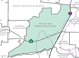
Rancho Peñasquitos is a suburban community in the northeastern part of the city of San Diego, California. It is named after the first Mexican land grant in the county, Rancho Santa Maria de Los Peñasquitos. Peñasquitos means "little cliffs" in Spanish. It abuts Los Peñasquitos Canyon Preserve, an open space preserve that offers hiking, biking, and equestrian trails. The community is commonly abbreviated "PQ."
San Pasqual Valley, historically spelled as San Pascual, is the northernmost community of the city of San Diego. It is named for the Kumeyaay village of San Pasqual that was once located there. It is bordered on the north by the city of Escondido, on the east and west by unincorporated land within San Diego County, and on the south by the city of Poway and the community of Rancho Bernardo. San Pasqual Valley is home to the San Diego Zoo Safari Park.

Torrey Hills is a community of 784 acres (317 ha) located in northern San Diego, California, United States. Torrey Hills is a part of District 1 which is represented by Councilmember Joe LaCava on the San Diego City Council.
Rancho Santa Maria de Los Peñasquitos was a 8,486-acre (34.34 km2) Mexican land grant in present-day southwestern San Diego County, California given in 1823 to Francisco María Ruiz. The name means "Saint Mary of the Little Cliffs". It encompassed the present-day communities of Mira Mesa, Carmel Valley, and Rancho Peñasquitos in northern San Diego city, and was inland from the Torrey Pines State Natural Preserve bluffs.

San Clemente Canyon is a canyon located in the city of San Diego, in San Diego County, California.
Marian Bear Memorial Park, a linear open space park, is along the canyon and in the southern tributary arroyos and mesa.

Los Peñasquitos Marsh Natural Preserve and Lagoon is a coastal marsh in San Diego County, California, United States situated at the northern edge of the City of San Diego, forming the natural border with Del Mar, California. This bar-built estuary, previously called The Soledad Lagoon, divides a colony of the endangered Pinus torreyana on a narrow coastal strip. Three streams empty into the lagoon: Carroll Creek, Carmel Creek, Los Peñasquitos Creek with a total drainage basin area of 95 square miles.

The California coastal sage and chaparral is a Mediterranean forests, woodlands, and scrub ecoregion located in southwestern California and northwestern Baja California (Mexico). It is part of the larger California chaparral and woodlands ecoregion.

Peters Canyon Regional Park is a regional park within the Orange County Regional Parks System in California. The park contains 354 acres of southern California wildlife, including coastal sage shrub, riparian, freshwater marsh, and grasslands, and is located within the boundaries of both Orange, California and Tustin, California. Peters Canyon was given to this city in 1992 by the Irvine Company who had used it previously for cattle grazing. The canyon is lined with a residential area on one side and open hills on the other. This canyon is commonly used by hikers, mountain bikers, and equestrians because of the trails that circumvent the 50 acre man-made lake, which was constructed by the Irvine Company in 1931, on the interior of the plot. The regional park is open from 7:00 AM to sunset every day of the week, save for the chance of rain or hazardous conditions, in which case the park will be closed for three days following the particular occurrence.

McGinty Mountain is a gabbroic mountain located in San Diego County, California near Jamul. Because of the gabbroic soil, the mountain supports numerous rare and endemic plant species, including half of the California's population of the Dehesa nolina. The mountain belongs to an ecological preserve collectively managed by The Nature Conservancy, the California Department of Fish and Wildlife, and the San Diego National Wildlife Refuge. The mountain is accessible through a 4.7 mi (7.6 km) long out-and-back hiking trail.

Hill Canyon is a deep canyon in the western Simi Hills and within northern Newbury Park and Thousand Oaks, in Ventura County, southern California.

Deer Ridge Open Space is a 188-acre public-owned open-space area in the southwest portion of the town of Newbury Park, California. It contains a series of north-facing mountainous ridges and canyons, dominated by chaparral and oak trees. It shares borders with the Santa Monica Mountains National Recreation Area to the south, and the Los Robles Trail traverses the length of Deer Ridge Open Space. Its main trailhead is located on Potrero Road, while a smaller access point is located at the southern end of Felton Street. The Los Robles Trail is the Conejo Open Space Conservation Agency’s longest trail, and connects to open-space areas and parks such as the Los Padres Open Space, Conejo Ridge Open Space, Hope Nature Preserve, Old Conejo Open Space, and the Los Vientos Open Space. The trail in Newbury Park provides panoramic views of the Conejo Valley and Santa Monica Mountains, before entering the Hope Nature Preserve. The Los Robles Trail provides more than 25 miles of contiguous trails connecting Newbury Park to Westlake Village in Los Angeles County. Immediately south of the Deer Ridge Open Space in Newbury Park are the Hidden Valley and Rancho Sierra Vista Satwiwa.


