
The Black Sea deluge is the best known of three hypothetical flood scenarios proposed for the Late Quaternary history of the Black Sea. One other flood scenario proposes a rapid, even catastrophic, rise in sea level of the Black Sea. [1] [2]
The Black Sea deluge is the best known of three hypothetical flood scenarios proposed for the Late Quaternary history of the Black Sea. One other flood scenario proposes a rapid, even catastrophic, rise in sea level of the Black Sea. [1] [2]
In 1997, William Ryan, Walter Pitman, Petko Dimitrov, and their colleagues first published the Black Sea deluge hypothesis. They proposed that a catastrophic inflow of Mediterranean seawater into the Black Sea freshwater lake occurred around 7600 years ago, c. 5600 BC . [3] [4]
As proposed, the Early Holocene Black Sea flood scenario describes events that would have profoundly affected prehistoric settlement in eastern Europe and adjacent parts of Asia and possibly was the basis of oral history concerning Noah's flood. [4] Some archaeologists support this theory as an explanation for the lack of Neolithic sites in northern Turkey. [5] [6] [7] In 2003, Ryan and coauthors revised the dating of the early Holocene flood to 8800 years ago, c. 6800 BC. [8]
Before that date, glacial meltwater had turned the Black and Caspian seas into vast freshwater lakes draining into the Aegean Sea. As glaciers retreated, some of the rivers emptying into the Black Sea declined in volume and changed course to drain into the North Sea. The levels of the lakes dropped through evaporation, while changes in worldwide hydrology caused global sea levels to rise. [8] [9]
The rising Mediterranean finally spilled over a rocky sill at the Bosporus. The event flooded 100,000 km2 (39,000 sq mi) of land and significantly expanded the Black Sea shoreline to the north and west. According to these researchers, 50 km3 (10 cu mi) of water poured through each day, two hundred times the flow of Niagara Falls. The Bosporus valley roared and surged at full spate for at least 300 days. They argued that the catastrophic inflow of seawater resulted from an abrupt sea-level jump that accompanied the Laurentide Ice Sheet collapse and the ensuing breach of a bedrock barrier in the Bosporus strait. [8] [9]
Popular discussion of this early Holocene Black Sea flood scenario was headlined in The New York Times in December 1996 [10] and later published as a book. [9] In a series of expeditions widely covered by mainstream media, a team of marine archaeologists led by Robert Ballard identified what appeared to be ancient shorelines, freshwater snail shells, drowned river valleys, tool-worked timbers, and man-made structures in roughly 100 metres (330 ft) of water off the Black Sea coast of modern Turkey. [11] [12]
In 2003 and 2007, a more ancient catastrophic flood scenario was proposed by Andrei L. Chepalyga for the Late Quaternary sea level rise of the Black Sea. [1] [2] [13] The hypothesis for a Late Pleistocene Great Flood argues that brackish Neoeuxinian Lake, which occupied the Black Sea basin, was rapidly inundated by glacial meltwater overflow from the Caspian Sea via the Manych-Kerch Spillway shortly after the Late Glacial Maximum, about 17,000–14,000 BP. These extensive meltwater flooding events linked several lacustrine and marine water bodies, starting with the southern edge of the Scandinavian and southward, through spillways to the Manych-Kerch and Bosphorus, ultimately forming what has been referred to as the Cascade of Eurasian Basins. [14] This event is argued to have caused a rapid, if not catastrophic, rise in the level of the Black Sea. It might have imposed substantial stresses upon contemporary human populations and remained in cultural memory as the Great Flood. The authors also suggested that the event might have stimulated the beginning of shipping and horse domestication. [1] [14]
In addition to the early Holocene "Noah’s Flood" scenario proposed by Ryan, Pitman, Dimitrov, and their colleagues [4] [8] and the Caspian Sea overflow scenario of Chepalyga, [13] [14] the non-catastrophic progressive flood model (or gradual inflow model) has been proposed to explain the Late Quaternary sea level history of the Black Sea. [2] [15]
About 8,000 YBP, the level of the Marmara Sea would have risen high enough for two-way flow to start. The evidence used to support this scenario includes the disparate ages of sapropel deposition in the eastern Mediterranean Sea and Black Sea; buried back-stepping barrier islands observed on the Black Sea shelf; and an under-water delta in the Marmara Sea, near the Bosporus Strait, composed of Black Sea sediments. [16] [17] [18]

Criticisms of the deluge hypothesis focus on the magnitude and pace of the water level rise in the Black Sea. With enough moderation of these features, the catastrophe hypothesis is voided. However, a few key points should be noted:
Opponents of the deluge hypothesis point to clues that water was flowing out of the Black Sea basin as late as 15,000 years ago. [23]
In this alternative scenario, much depends on the evolution of the Bosphorus. According to a study from 2001, the modern sill is 32–34 m (105–112 ft) below sea level and consists of Quaternary sand over-lying Paleozoic bedrock in which three sills are found at 80–85 m (260–280 ft) below sea level. Sedimentation on these sills started before 10,000 years ago and continued until 5,300 years ago. [24]
A large part of the academic geological community also continues to reject the idea that there could have been enough sustained long-term pressure by water from the Aegean to dig through a supposed isthmus at the present Bosphorus or enough of a difference in water levels, if at all, between the two water basins. [25]
In 2007, a research anthology on the topic was published which makes much of the earlier Russian research available in English for the first time and combines it with more recent scientific findings. [26]
According to a 2009 study by Liviu Giosan, Florin Filip, and Ștefan Constatinescu, the level in the Black Sea before the marine reconnection was 30 m (100 ft) below present sea level, rather than the 80 m (260 ft) (or lower) of the catastrophe theories. If the flood occurred at all, the sea level increase and the flooded area during the reconnection were significantly smaller than previously proposed. Since the depth of the Bosphorus, in its middle furrow, at present varies from 36 to 124 m (118 to 407 ft), with an average depth of 65 m (213 ft), a calculated Stone Age shoreline in the Black Sea lying 30 m (100 ft) lower than in the present day would imply that the contact with the Mediterranean might never have been broken during the Holocene, and hence there could have been no sudden waterfall-style transgression. [27] The flooding could have been "not so big". [28]
In 2011, several authors concluded that "there is no underwater archaeological evidence to support any catastrophic submergence of prehistoric Black Sea settlements during the late Pleistocene or early Holocene intervals". [29]
A 2012 study based on process length variation of the dinoflagellate cyst Lingulodinium machaerophorum shows no evidence for catastrophic flooding. [30] Geophysical, geochronological, and geochemical evidence points to a "fast transgression" of the submergence lasting between 10 and 200 years. [31]
A 2022 literature review concluded that there was insufficient evidence for a flood scenario. It was more likely that the waters of the Black Sea itself gradually outflowed to the Mediterranean. There was also no archaeological evidence of humans evacuating the premises during the relevant time frame. [32]

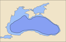
The Black Sea is a marginal mediterranean sea lying between Europe and Asia, east of the Balkans, south of the East European Plain, west of the Caucasus, and north of Anatolia. It is bounded by Bulgaria, Georgia, Romania, Russia, Turkey, and Ukraine. The Black Sea is supplied by major rivers, principally the Danube, Dnieper and Dniester. Consequently, while six countries have a coastline on the sea, its drainage basin includes parts of 24 countries in Europe.
The Holocene is the current geological epoch, beginning approximately 11,700 years ago. It follows the Last Glacial Period, which concluded with the Holocene glacial retreat. The Holocene and the preceding Pleistocene together form the Quaternary period. The Holocene is an interglacial period within the ongoing glacial cycles of the Quaternary, and is equivalent to Marine Isotope Stage 1.

The Quaternary is the current and most recent of the three periods of the Cenozoic Era in the geologic time scale of the International Commission on Stratigraphy (ICS). It follows the Neogene Period and spans from 2.58 million years ago to the present. As of 2023, the Quaternary Period is divided into two epochs: the Pleistocene and the Holocene ; a third epoch, the Anthropocene, has recently been proposed, but it is not officially recognised by the ICS.
The Younger Dryas, which occurred circa 12,900 to 11,700 years Before Present (BP), was a stadial (cooling) event which marked a return to glacial conditions, temporarily reversing the climatic warming of the preceding Late Glacial Interstadial. The Younger Dryas was the most severe and longest lasting of several interruptions to the warming of the Earth's climate. The end of the Younger Dryas marks the beginning of the current Holocene epoch.

The Last Glacial Period (LGP), also known colloquially as the Last Ice Age or simply Ice Age, occurred from the end of the Last Interglacial to the end of the Younger Dryas, encompassing the period c. 115,000 – c. 11,700 years ago.

Sundaland is a biogeographical region of South-eastern Asia corresponding to a larger landmass that was exposed throughout the last 2.6 million years during periods when sea levels were lower. It includes Bali, Borneo, Java, and Sumatra in Indonesia, and their surrounding small islands, as well as the Malay Peninsula on the Asian mainland.

A jökulhlaup is a type of glacial outburst flood. It is an Icelandic term that has been adopted in glaciological terminology in many languages. It originally referred to the well-known subglacial outburst floods from Vatnajökull, Iceland, which are triggered by geothermal heating and occasionally by a volcanic subglacial eruption, but it is now used to describe any large and abrupt release of water from a subglacial or proglacial lake/reservoir.
In geomorphology, an outburst flood—a type of megaflood—is a high-magnitude, low-frequency catastrophic flood involving the sudden release of a large quantity of water. During the last deglaciation, numerous glacial lake outburst floods were caused by the collapse of either ice sheets or glaciers that formed the dams of proglacial lakes. Examples of older outburst floods are known from the geological past of the Earth and inferred from geomorphological evidence on Mars. Landslides, lahars, and volcanic dams can also block rivers and create lakes, which trigger such floods when the rock or earthen barrier collapses or is eroded. Lakes also form behind glacial moraines or ice dams, which can collapse and create outburst floods.

The Last Glacial Maximum (LGM), also referred to as the Last Glacial Coldest Period, was the most recent time during the Last Glacial Period where ice sheets were at their greatest extent 26,000 and 20,000 years ago. Ice sheets covered much of Northern North America, Northern Europe, and Asia and profoundly affected Earth's climate by causing a major expansion of deserts, along with a large drop in sea levels.

The Laurentide Ice Sheet was a massive sheet of ice that covered millions of square miles, including most of Canada and a large portion of the Northern United States, multiple times during the Quaternary glacial epochs, from 2.58 million years ago to the present.
The Holocene Climate Optimum (HCO) was a warm period in the first half of the Holocene epoch, that occurred in the interval roughly 9,500 to 5,500 years BP, with a thermal maximum around 8000 years BP. It has also been known by many other names, such as Altithermal, Climatic Optimum, Holocene Megathermal, Holocene Optimum, Holocene Thermal Maximum, Hypsithermal, and Mid-Holocene Warm Period.
The Holocene glacial retreat is a geographical phenomenon that involved the global retreat of glaciers (deglaciation) that previously had advanced during the Last Glacial Maximum. Ice sheet retreat initiated ca. 19,000 years ago and accelerated after ca. 15,000 years ago. The Holocene, starting with abrupt warming 11,700 years ago, resulted in rapid melting of the remaining ice sheets of North America and Europe.
Dinocysts or dinoflagellate cysts are typically 15 to 100 µm in diameter and produced by around 15–20% of living dinoflagellates as a dormant, zygotic stage of their lifecycle, which can accumulate in the sediments as microfossils. Organic-walled dinocysts are often resistant and made out of dinosporin. There are also calcareous dinoflagellate cysts and siliceous dinoflagellate cysts.

In climatology, the 8.2-kiloyear event was a sudden decrease in global temperatures that occurred approximately 8,200 years before the present, or c. 6,200 BC, and which lasted for the next two to four centuries. It defines the start of the Northgrippian age in the Holocene epoch. The cooling was significantly less pronounced than during the Younger Dryas cold period that preceded the beginning of the Holocene. During the event, atmospheric methane concentration decreased by 80 ppb, an emission reduction of 15%, by cooling and drying at a hemispheric scale.

Bond events are North Atlantic ice rafting events that are tentatively linked to climate fluctuations in the Holocene. Eight such events have been identified. Bond events were previously believed to exhibit a roughly c. 1,500-year cycle, but the primary period of variability is now put at c. 1,000 years.

The Weichselian glaciation was the last glacial period and its associated glaciation in northern parts of Europe. In the Alpine region it corresponds to the Würm glaciation. It was characterized by a large ice sheet that spread out from the Scandinavian Mountains and extended as far as the east coast of Schleswig-Holstein, northern Poland and Northwest Russia. This glaciation is also known as the Weichselian ice age, Vistulian glaciation, Weichsel or, less commonly, the Weichsel glaciation, Weichselian cold period (Weichsel-Kaltzeit), Weichselian glacial (Weichsel-Glazial), Weichselian Stage or, rarely, the Weichselian complex (Weichsel-Komplex).
The Epoch of Extreme Inundations (EEI) is a hypothetical epoch during which four landforms in the Pontic–Caspian steppe—marine lowlands, river valleys, marine transgressions and slopes —were widely inundated. Catastrophic events during the epoch are theorized to have influenced prehistoric human life.

Mount Erciyes, also known as Argaeus, its etymon, is an inactive volcano in Kayseri Province, Turkey. It is a large stratovolcano surrounded by many monogenetic vents and lava domes, and one maar. The bulk of the volcano is formed by lava flows of andesitic and dacitic composition. At some time in the past, part of the summit collapsed towards the east.

The Zanclean flood or Zanclean deluge is theorized to have refilled the Mediterranean Sea 5.33 million years ago. This flooding ended the Messinian salinity crisis and reconnected the Mediterranean Sea to the Atlantic Ocean, although it is possible that even before the flood there were partial connections to the Atlantic Ocean. The re-connection marks the beginning of the Zanclean age which is the name given to the earliest age on the geologic time scale of the Pliocene.

Prof. Dr. Petko Stoyanov Dimitrov was a Bulgarian marine geologist and oceanographer from the Institute of Oceanology - Bulgarian Academy of Sciences in Varna. He has been an early proponent of the Black Sea deluge hypothesis which gained public notoriety at the end of the XXc.