
The Borough of Charnwood is a local government district with borough status in the north of Leicestershire, England, which has a population of 166,100 as of the 2011 census. It borders Melton to the east, Harborough to the south east, Leicester and Blaby to the south, Hinckley and Bosworth to the south west, North West Leicestershire to the west and Rushcliffe in Nottinghamshire to the north. It is named after Charnwood Forest, an area which the borough contains much of.

Shepshed (often known until 1888 as Sheepshed, is a town in Leicestershire, England with a population of 13,505 at the 2011 census. It is part of the borough of Charnwood local authority, where Shepshed is the second biggest settlement after the town of Loughborough.
The Leicestershire and Rutland Wildlife Trust (LRWT) is one of 46 wildlife trusts across the United Kingdom. It manages nature reserves in Leicestershire and Rutland, and was founded in 1956 as the Leicestershire and Rutland Trust for Nature Conservation. As of January 2018, it has over 16,000 members, a staff of about 25 and more than 500 volunteers. It is based in Leicester, and is managed by a Council of Trustees which is elected by the members. It is a charity which covers all aspects of nature conservation, and works to protect wild places and wildlife.

Loughborough is a constituency in Leicestershire represented in the House of Commons of the UK Parliament since 2019 by Jane Hunt, a Conservative. From 2010 until 2019, it was represented by Nicky Morgan, who served in the governments of David Cameron and Boris Johnson. In 2020, she was elevated to the Peerage and became a member of the House of Lords. The constituency is a considered a bellwether, as it has reflected the national result at every general election since February 1974.
The Charnwood Forest Canal, sometimes known as the "Forest Line of the Leicester Navigation", was opened between Thringstone and Nanpantan, with a further connection to Barrow Hill, near Worthington, in 1794
Eyebrook Reservoir is a 201.3-hectare (497-acre) reservoir and biological Site of Special Scientific Interest which straddles the border between Leicestershire and Rutland in central England. The closest towns are Corby and Uppingham.

Swithland Reservoir is a reservoir in the English county of Leicestershire. It is north-east of the village of Swithland from which it takes its name, north-west of Rothley and approximately 133 metres (145 yd) south-west of Mountsorrel Quarry. It is part of the 187.1-hectare (462-acre) Buddon Wood and Swithland Reservoir Site of Special Scientific Interest (SSSI).
Loughborough Meadows is a 60.5 hectares biological Site of Special Scientific Interest on the northern outskirts of Loughborough in Leicestershire, England. An area of 35.3 hectares is managed as a nature reserve by the Leicestershire and Rutland Wildlife Trust.
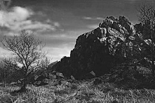
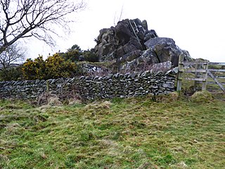
Beacon Hill, Hangingstone and Outwoods is a 147.5-hectare (364-acre) biological and geological Site of Special Scientific Interest (SSSI) south of Loughborough in Leicestershire. It is also a Geological Conservation Review and a Nature Conservation Review site. The Outwoods and Beacon Hill are part of The National Forest. Two areas in the SSSI, Beacon Hill and Jubilee Woods are country parks managed by Leicestershire County Council, and The Outwoods is managed by Charnwood Borough Council.

Twenty Acre Piece is an 8.1-hectare (20-acre) biological Site of Special Scientific Interest and registered common land east of Loughborough in Leicestershire.

Grace Dieu and High Sharpley is an 86 hectare biological and geological Site of Special Scientific Interest between Coalville and Shepshed in Leicestershire. Grace Dieu Quarry is a Geological Conservation Review site.

Grantham Canal SSSI is a 9.5-hectare (23-acre) biological Site of Special Scientific Interest which runs along a stretch of the Grantham Canal and its banks between Redmile and Harby in Leicestershire.

Newhurst Quarry is a 9.5 hectares geological Site of Special Scientific Interest on the southern outskirts of Shepshed in Leicestershire. It is a Geological Conservation Review site.

Saddington Reservoir is a canal reservoir and 19.1 hectares biological Site of Special Scientific Interest south of Saddington in Leicestershire. The reservoir was built between 1793 and 1797 to supply water to the Grand Union canal.

Shepshed Cutting is a 6.0 hectares geological Site of Special Scientific Interest west of Shepshed in Leicestershire.

Barrow Gravel Pits is a 35.6 hectares biological Site of Special Scientific Interest in Barrow upon Soar in Leicestershire.

One Barrow Plantation is a 1.8 hectares geological Site of Special Scientific Interest (SSSI) south-west of Shepshed in Leicestershire. It is a Geological Conservation Review site. Part of the site is in the Blackbrook Reservoir biological SSSI.

Ives Head is a 5 hectares geological Site of Special Scientific Interest south of Shepshed in Leicestershire. It is a Geological Conservation Review site.

Lea Meadows is a 12-hectare (30-acre) nature reserve east of Markfield in Leicestershire. It is owned and managed by the Leicestershire and Rutland Wildlife Trust. It is part of the Ulverscroft Valley, which is a Site of Special Scientific Interest, and part of it is a scheduled monument.
