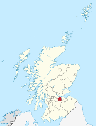
West Lothian is one of the 32 council areas of Scotland, and was one of its historic counties. The county was called Linlithgowshire until 1925. The historic county was bounded geographically by the Avon to the west and the Almond to the east. The modern council area occupies a larger area than the historic county. It was reshaped following local government reforms in 1975: some areas in the west were transferred to Falkirk; some areas in the east were transferred to Edinburgh; and some areas that had formerly been part of Midlothian were added to West Lothian.
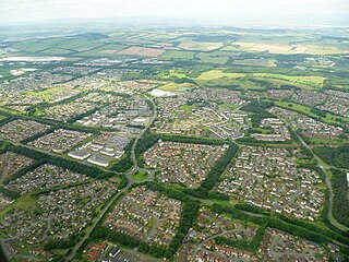
Livingston is the largest town in West Lothian, Scotland. Designated in 1962, it is the fourth post-war new town to be built in Scotland. Taking its name from a village of the same name incorporated into the new town, it was originally developed in the then-counties of Midlothian and West Lothian along the banks of the River Almond. It is situated approximately fifteen miles (25 km) west of Edinburgh and thirty miles (50 km) east of Glasgow, and is close to the towns of Broxburn to the north-east and Bathgate to the north-west.

Lamlash is a village on the Isle of Arran, in the Firth of Clyde, Scotland. It lies three miles south of the island's main settlement and ferry port Brodick, in a sheltered bay on the island's east coast, facing the Holy Isle. Lamlash is the seat of Arran's local government offices, and is also the location of the island's police station, secondary school and hospital. In common with the rest of the island, the village's main industry is tourism and the public sector is also an important employer. Lamlash has an RNLI Lifeboat station with a B class Atlantic 75 lifeboat, covering the inshore waters around the coast of Arran, and in summer, there is a regular ferry service from Lamlash harbour to Holy Isle. The village has several buildings of historical interest, including Hamilton Terrace, which consists of two rows of single storey-and-attic cottages on the Lamlash seafront, arranged in pairs.

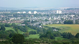
Broxburn is a town in West Lothian, Scotland. It is 12 miles (19 km) from the West End of Edinburgh, 5 miles (8.0 km) from Edinburgh Airport and 5 miles (8.0 km) to the north of Livingston. Originally a village known as Easter Strathbock in the medieval period, by 1600, the village had become known as Broxburn. The area developed rapidly during the Victorian era as a result of industralisation related to shale oil extraction. While much of the industry in the area is now diminished, the town has continued to grow following new residential development, resulting in Broxburn forming a conurbation with neighbouring Uphall. It lies just to the south of Winchburgh.

Uphall is a village in West Lothian, Scotland. It is a swiftly growing village in a conurbation with Broxburn to the east, Dechmont to the west and the major town of Livingston to the south west. Uphall is 30 miles from Glasgow and 14 miles from Edinburgh in the Scottish Lowlands. Uphall Station and Pumpherston are separate villages that lie to the south of Uphall.

Pumpherston is a village in West Lothian, Scotland. Originally a small industrial village housing works for the nearby shale mine and works, it now forms the eastern part of the new town of Livingston, which was constructed to the west of Pumpherston in the late 1960s and quickly grew to incorporate Pumpherston in its wider urban settlement, as defined by the General Register Office for Scotland (GROS). The village of Uphall Station lies immediately to the north. It is twinned with the village of Mtarfa, Malta.

Fauldhouse is a village in West Lothian, Scotland. It is about halfway between Glasgow and Edinburgh. The nearest towns to Fauldhouse are Whitburn and Livingston. Other neighbouring villages include Longridge, Shotts and Stoneyburn. At approximately 750 feet above sea level, Fauldhouse is one of the highest villages in West Lothian.

Seafield is a small village in West Lothian, Scotland. Seafield lies 1+1⁄4 miles (2.0 km) east of Blackburn, 2 miles (3.2 km) southeast of Bathgate and 3 miles (4.8 km) west of Livingston.

Mid Calder is a village in West Lothian, Scotland. It is located on a steep hill overlooking the River Almond and Calder Wood, around 15 miles (24 km) west of Edinburgh. The settlement has been on a major crossroads since its origin some time in the 11th century.

West Calder is a village in the council area of West Lothian, Scotland, located four miles west of Livingston. Historically it is within the County of Midlothian. The village was an important centre in the oil shale industry in the 19th and 20th centuries. West Calder has its own railway station.
Moredun is a district in the south-east of Edinburgh, the capital of Scotland. It is east of Liberton, while Craigour is situated just to its north.

Mossend is a small town in North Lanarkshire, Scotland, located beside the town of Bellshill, west of the villages of Holytown and New Stevenston, north of the larger town of Motherwell and south of the Eurocentral industrial park and the M8 motorway. Along with Holytown, it forms a council ward which had a population of 13,480 in 2019, Mossend's estimated population being around half of that total.
The National Museum of Rural Life, previously known as the Museum of Scottish Country Life, is based at Wester Kittochside farm, lying between East Kilbride in South Lanarkshire and Carmunnock in Glasgow. It is run by National Museums Scotland.

Kirknewton is a village formerly in the county of Midlothian and, since 1975, in West Lothian, Scotland. The population of the Kirknewton Community Council district is 2200, which includes the village and surrounding areas. It lies south of the A71 from Edinburgh to Livingston, and north of the A70, the high-level road that runs along the north side of the Pentland Hills from Edinburgh to Carnwath and Lanark. Much of the village stands back from the B7031, which links the two main "A" roads. To the south-east of the village is Morton.

Murieston is a primarily residential district on the southern edge of Livingston, West Lothian, Scotland. It lies to the south-east of Bellsquarry.

Ballencrieff Castle, also known as Ballencrieff House, is a large tower house at Ballencrieff, East Lothian, Scotland. It is located three miles north west of Haddington, and one mile south of Aberlady.

Mavisbank is a country house outside Loanhead, south of Edinburgh in Midlothian, Scotland. It was designed by architect William Adam in collaboration with his client, Sir John Clerk of Penicuik, and was constructed between 1723 and 1727. The first Palladian villa in Scotland, it is described by Historic Scotland as "one of Scotland's most important country houses". It was altered in the 19th century, but suffered decades of neglect in the 20th century. The interiors were gutted by fire in 1973, and the house remains a ruin. As of May 2009, plans exist to partially restore the building and manage the estate as a community asset.

Sir James Gowans was an Edinburgh architect and builder.


