Related Research Articles

East Stour is a village and civil parish in the ceremonial county of Dorset in southern England. It lies within the Dorset administrative district, about two miles south of the town of Gillingham. The village is 1⁄2 mile from the east bank of the River Stour in the Blackmore Vale and two miles west of the broadly conical local landmark Duncliffe Hill. Above the west bank of the river, about one mile away, is the village of West Stour. The A30 London to Penzance road passes through the village. In the 2011 census the civil parish had a population of 573.

Shaftesbury is a town and civil parish in Dorset, England. It is on the A30 road, 20 miles west of Salisbury and 23 miles north-northeast of Dorchester, near the border with Wiltshire. It is the only significant hilltop settlement in Dorset, being built about 215 metres above sea level on a greensand hill on the edge of Cranborne Chase.

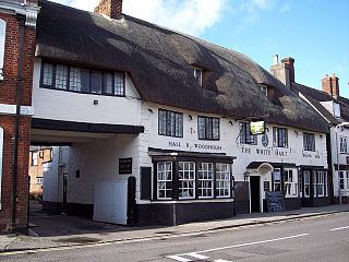
Stalbridge is a town and civil parish in Dorset, England, situated in the Blackmore Vale, near the border with Somerset. In the 2011 census the civil parish—which includes the hamlets of Stalbridge Weston, and Thornhill—had 1,160 households and a population of 2,698. The nearest towns are Sturminster Newton, four miles southeast, Sherborne, 6 mi (10 km) west, and Shaftesbury, 7 mi (11 km) northeast. Stalbridge is situated on the A357 on a low limestone ridge, one mile west of the River Stour. It officially became a town in April 1992.

The Blackmore Vale is a vale, or wide valley, in north Dorset, and to a lesser extent south Somerset and southwest Wiltshire in southern England.
Sturminster Newton is a town and civil parish in the Blackmore Vale area of Dorset, England. It is situated on a low limestone ridge in a meander of the River Stour. The town is at the centre of a large dairy agriculture region, around which the town's economy is built. The larger part of the town (Sturminster) lies on the north side of the river, and includes most shops and services, whilst to the south is the smaller Newton.

Gillingham is a town and civil parish in the Blackmore Vale area of Dorset, England. It lies on the B3095 and B3081 roads, approximately four miles south of the A303 trunk road and five miles northwest of Shaftesbury. It is the most northerly town in the county. In the 2011 census the civil parish had a population of 11,756. The neighbouring hamlets of Peacemarsh, Bay and Wyke have become part of Gillingham as it has expanded.

Marnhull is a village and civil parish in the county of Dorset in southern England. It lies in the Blackmore Vale, three miles north of Sturminster Newton. The resort towns of Bournemouth and Weymouth are approximately 30 miles south. Marnhull is sited on a low ridge of Corallian limestone above the valley of the River Stour, which forms the northern and western boundaries of the parish. In the 2011 census the parish had 962 dwellings, 905 households and a population of 1,998.

Alton Pancras is a small village and civil parish in Dorset, England. In the 2011 census the civil parish had a population of 175.

Chetnole is a village and civil parish in the county of Dorset in southern England. It lies approximately 6 miles (9.7 km) south-southwest of Sherborne and 5.5 miles (8.9 km) southeast of Yeovil in Somerset. It is sited on Oxford clay by the small Wriggle River at the western end of the Blackmore Vale. There are around 128 houses in the village. It has a railway station on the Heart of Wessex Line that is served by Great Western Railway services. Dorset County Council estimate that in 2013 the population of the parish was 330. In the 2011 census the population of Chetnole parish combined with the small parish of Stockwood to the west was 344.

Compton Abbas is a village and civil parish in north Dorset, England. It lies 3 miles south of the town of Shaftesbury. It is sited on greensand strata on the edge of the Blackmore Vale, below the chalk downs of Cranborne Chase. On top of these hills is Compton Abbas Airfield. The A350 road between Wiltshire and the south coast passes through the village. In the 2011 census the civil parish had a population of 216. The name Compton Abbas derives from the Saxon "cumb-ton", meaning 'village in a narrow valley', plus "abbas" which refers to Shaftesbury Abbey. The church, St. Mary's, was built in 1866 to replace the older structure which was more remote from the village.

Fontmell Magna is a village and civil parish in Dorset, England. It is situated in the Blackmore Vale, close to the chalk hills of Cranborne Chase, on the A350 road five miles south of Shaftesbury and eight miles north of Blandford Forum. In the 2011 census the parish had a population of 734.

Holt is a village in east Dorset, England, 2 miles (3.2 km) north of Wimborne Minster. The village had a population of 1,265 in 2001. The electoral ward of the same name had a population of 2,286 at the 2011 census. It also includes Hinton Martell and Horton.

Motcombe is a village and civil parish in north Dorset, England. It lies about two miles north of Shaftesbury. It is sited on Kimmeridge clay soil beneath hills at the edge of the Blackmore Vale. The parish is one of the largest in Dorset. In the 2011 census the parish had 611 dwellings, 564 households and a population of 1,474.

Okeford Fitzpaine is a village and civil parish in the English county of Dorset, situated in the Blackmore Vale three miles south of the town of Sturminster Newton. It is sited on a thin strip of greensand under the scarp face of the Dorset Downs. In the 2011 census the civil parish—which includes the village of Belchalwell to the west and most of the hamlet of Fiddleford to the north—had 404 dwellings, 380 households and a population of 913.
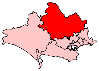
North Dorset is a constituency represented in the House of Commons of the UK Parliament since 2015 by Simon Hoare, a Conservative.

Hazelbury Bryan is a village and civil parish in the county of Dorset in southern England. It is situated in the Blackmore Vale, approximately five miles southwest of the small town of Sturminster Newton. The parish includes the hamlets of Droop, Kingston, Parkgate, Pidney, Pleck, Wonston and Woodrow. In the 2011 census the parish had 480 dwellings, 454 households and a population of 1,059.

The 2011 West Dorset District Council election was held on Thursday 5 May 2011 to elect councillors to West Dorset District Council in England. It took place on the same day as other district council elections in the United Kingdom. The whole of this 48-seat council was up for election.
Marshwood Vale is an electoral ward in Dorset. Since 2019, the ward has elected 1 councillor to Dorset Council.
Stour and Allen Vale is an electoral ward in Dorset. Since 2019, the ward has elected 1 councillor to Dorset Council.
References
- ↑ "Blackmore Vale (Ward, United Kingdom) - Population Statistics, Charts, Map and Location". www.citypopulation.de. Retrieved 2024-02-22.
- ↑ "Area profile for Blackmore Vale - Dorset Council". gi.dorsetcouncil.gov.uk. Retrieved 2024-02-24.
