
Christchurch is a town and civil parish in Dorset on the south coast of England. The town covers an area of 19.5 square miles (51 km2) and had a population of 48,368 in 2013. It adjoins Bournemouth to the west, with the New Forest to the east. Part of the historic county of Hampshire, Christchurch was a borough within the administrative county of Dorset from 1974 until 2019, when it became part of the new Bournemouth, Christchurch and Poole unitary authority.

Pokesdown is a suburb of Bournemouth in Dorset, England. It lies just east of Boscombe and west of Southbourne.
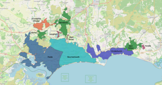
The South East Dorset conurbation is a multi-centred conurbation on the south coast of Dorset in England. The main population centres are Bournemouth, Christchurch and Poole, which together form the single unitary authority of Bournemouth, Christchurch and Poole; however, the urbanised area spreads into the Dorset unitary authority and into the New Forest District as far east as Barton on Sea. There are a number of satellite towns peripheral to these main urban centres. In clockwise rotation these include: Wareham, Verwood and Ringwood (Hampshire). The urban area is generally surrounded by a green belt.

Holdenhurst is a small isolated village situated in the green belt land of the north-east suburbs of Bournemouth, England. The village comprises fewer than 30 dwellings, two farms and the parish church. There are no shops and few local facilities in the village.
Dorset County Council (DCC) was the county council for the county of Dorset in England. It provided the upper tier of local government, below which were district councils, and town and parish councils. The county council had 46 elected councillors and was based at County Hall in Dorchester. The council was abolished on 31 March 2019 as part of structural changes to local government in Dorset.
Bournemouth East and Christchurch is a former United Kingdom Parliamentary constituency. It returned one Member of Parliament, using the first past the post electoral system from the 1950 United Kingdom general election until the constituency was abolished in 1974.
County Gates is the historic crossing point between the shire counties of Dorset and Hampshire. On April 1, 1974 when Bournemouth and Christchurch were incorporated into Dorset, it became the main crossing point between the Borough of Poole and the Borough of Bournemouth. Since 2019, both Borough of Poole and Borough of Bournemouth have become part of the unitary authority Bournemouth, Christchurch and Poole, hence County Gates is no longer a crossing point. County Gates sits on the A35 road.

The History of Bournemouth and human settlement in the surrounding area goes back for thousands of years.

Dorset is a county in South West England. The county is largely rural and therefore does not have a dense transport network, and is one of the few English counties without a motorway. Due to its position on the English Channel coast, and its natural sheltered harbours, it has a maritime history, though lack of inland transport routes have led to the decline of its ports.
The Ringwood, Christchurch and Bournemouth Railway was a railway company to link Christchurch and Bournemouth, England, to the London and South Western Railway's Southampton and Dorchester line at Ringwood. The RC&BR opened in 1862 from Christchurch to Ringwood, and was extended to Bournemouth in 1870, sharing in the growing popularity of the town. However the route was circuitous, and the London and South Western Railway opened a shorter route between Brockenhurst and Christchurch via Sway in 1888, making the Ringwood to Christchurch section a branch line.

Bournemouth Corporation Tramways served the town of Bournemouth in Dorset from 23 July 1902 until 8 April 1936.
Charminster is a residential and commercial suburb of Bournemouth in Dorset, situated between the suburbs of Springbourne and Winton. It was incorporated into the County Borough of Bournemouth in 1901.

St Catherine's Hill is a 53-metre (174 ft) hill in the borough of Christchurch which, together with Ramsdown and Blackwater hills, forms a ridge between the Avon and Stour valleys. It is a Site of Special Scientific Interest with some areas additionally designated as Special Protection Areas and/or Special Areas of Conservation. The hill provides a range of habitats with both wet and dry heathland, coniferous and broadleaf woodland and scrubland; and is home to some rare flora and fauna including the sand lizard, smooth snake, silver-studded blue butterfly and two types of carnivorous plant.

Bournemouth, Christchurch and Poole (BCP) is a unitary authority area in the ceremonial county of Dorset, England. It was created on 1 April 2019 by the merger of the areas that were previously administered by the unitary authorities of Bournemouth and Poole, and the non-metropolitan district of Christchurch. The authority covers much of the area of the South Dorset conurbation.

Bournemouth, Christchurch and Poole Council is a unitary local authority for the district of Bournemouth, Christchurch and Poole in England that came into being on 1 April 2019. It was created from the areas that were previously administered by the unitary authorities of Bournemouth and Poole and the non-metropolitan district of Christchurch.

The 2019 Bournemouth, Christchurch and Poole Council election took place on 2 May 2019 to elect the inaugural members of Bournemouth, Christchurch and Poole Council in England, formed from the former unitary authorities of Bournemouth and Poole, and borough of Christchurch. At the same time an election for the new Christchurch Town Council was held.

Richmond Hill is an area of Bournemouth, Dorset, England. Just to the north of Bournemouth Town Centre, south of Richmond Park and west of Lansdowne. The area is around a road of the same name.

