
Newcastle upon Tyne, often simply Newcastle, is the largest city and metropolitan borough in North East England. It forms the core of the Tyneside conurbation, the eighth most populous urban area in the United Kingdom. The city is situated on the River Tyne's northern bank, approximately 8.5 mi (13.7 km) from the North Sea.

Fenham is an area of the west-end of Newcastle upon Tyne, England. It lies to the west of the city centre, and is bounded on the north and east by a large area of open land known as the Town Moor. To the south lies Benwell, West Denton lies to the west, Blakelaw and Cowgate to the north, and Arthur's Hill and Spital Tongues to the east.
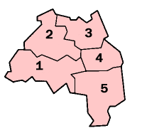
A civil parish is a country subdivision, forming the lowest unit of local government in England. There are 10 civil parishes in the ceremonial county of Tyne and Wear, most of the county being unparished; North Tyneside and South Tyneside are completely unparished. It is the County of England with the least count of civil parishes. At the 2001 census, there were 41,044 people living in the 10 parishes, accounting for 3.8 per cent of the county's population.
Newcastle upon Tyne Central is a constituency represented in the House of Commons of the UK Parliament since 2010 by Chi Onwurah of the Labour Party. As with all constituencies, the constituency elects one Member of Parliament (MP) by the first past the post system of election at least every five years. At the 2017 and 2019 general elections, the constituency was the first to officially declare its result. It narrowly beat Houghton and Sunderland South, which had declared first in 2010 and 2015 (as did its predecessor Sunderland South in the four preceding general elections.

Cresswell is a village in Northumberland, England. It is about 4 miles (6 km) to the north of Ashington, on the North Sea coast.
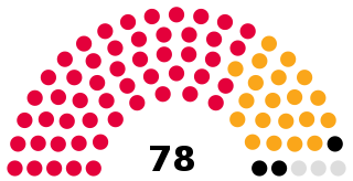
Newcastle City Council is the local government authority for the city and metropolitan borough of Newcastle upon Tyne. The council consists of 78 councillors, three for each of the 26 wards in the city. It is currently controlled by the Labour Party, led by Councillor Nick Forbes. Councillor Habib Rahman serves as the Lord Mayor and Councillor Karen Robinson serves as Deputy Lord Mayor and Sheriff. The council is a member of the North of Tyne Combined Authority.
Dinnington is a village and civil parish in the city of Newcastle upon Tyne in Tyne and Wear, England. It is about 9 miles (14 km) north of the city centre, and about 5 miles (8.0 km) north-east of Newcastle International Airport. According to the 2011 Census, Dinnington Parish has 737 households and a population of 1,636; of whom 358 are 65 or over.
Hazlerigg is a village and civil parish north of the City of Newcastle upon Tyne in Tyne and Wear, England. It is about 5 miles (8.0 km) north of the city centre, on the A1. It is split between Newcastle upon Tyne and North Tyneside, each side of the A1 being a different district. The parish council administer the Newcastle side, whereas the area located in North Tyneside is unparished. Much of the Newcastle Great Park development is within the area administered by the Hazlerigg Parish Council. Located in the village is a post office, a fish & chip shop, a beauty salon, a hairdresser, a garage, a convenience store and a social club that is now open under new management. In spite of having a population of 1,053, and almost 800 homes, Hazlerigg has never had a pub. The population of the civil Parish taken at the 2011 Census was 980.
North Gosforth is a suburb and civil parish in the City of Newcastle upon Tyne in Tyne and Wear, England. It is north of the city centre, and has a population of 3,527, increasing to 5,629 at the 2011 Census.

Woolsington is a village in and civil parish of Newcastle upon Tyne, England. It is located north-west of the city centre, covering a large geographical area. It was also formerly an electoral ward, although the ward was slightly larger than the civil parish, extending slightly further south. The parish also includes Newbiggin Hall, Woolsington village and Newcastle Airport. It had a population of 11,160 as of the 2011 Census.

Blakelaw is an electoral ward situated in the West End of the city of Newcastle upon Tyne in North East England. The population of the ward is 11,186, which is 4.6% of the city's population. Car ownership in the area is 50.6%: this is lower than the city average of 54.7%, increasing to 11,507 at the 2011 Census. House prices in this area average at £114,000.

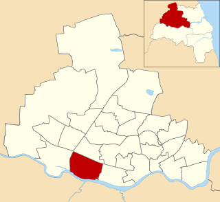
Arthur's Hill is a district of Newcastle upon Tyne. It lies approximately 1 mile west of Newcastle City Centre. It is bordered by Fenham to the west, Elswick to the south, and Spital Tongues to the north west. It gives name to a Newcastle City Council electoral ward with a population of 14,507. The area was part of the Westgate and Wingrove electoral wards up until 2018.
Benwell and Scotswood is an electoral ward of Newcastle upon Tyne in North East England. The ward encompasses the Benwell and Scotswood housing areas, as well as the Newcastle Business Park, which is located on the banks of the River Tyne and houses offices of companies such as British Airways and the Automobile Association. The population of the ward is 13,759, which is 5.3% of the total population of Newcastle upon Tyne. Car ownership in the area is 45.1%, lower than the city average of 54.7%. The 2011 Census gave a population of 12,694.

Newhall is a suburban settlement located in Swadlincote, South Derbyshire, England. As of the 2011 census it had a population of 776. The village of Stanton is nearby.

Springwell Village is a village in the City of Sunderland, bordering Gateshead, approximately 7.6 miles (12.2 km) from Newcastle upon Tyne, 9 miles (14 km) from Sunderland, and 13 miles (21 km) from Durham. In 2011, Census data for the City of Sunderland ward of Washington West recorded a total population of 11,833.

Henshaw is a small village and civil parish in Northumberland, within the vicinity of the ancient Hadrian's Wall. It is located around 11.5 miles (19 km) from Hexham, 25.5 miles (41 km) from Carlisle, and 33 miles (53 km) from Newcastle upon Tyne.

Horsley is a small village and civil parish in Northumberland, England. The village lies around 11 miles (18 km) from Newcastle upon Tyne and 12 miles (19 km) from Hexham.

RAF Blakelaw was a Royal Air Force station which acted as headquarters for No.13 Group during the Second World War and which was located in Blakelaw, Northumberland.
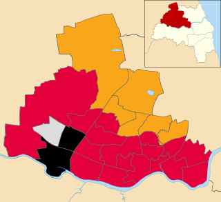
The 2021 Newcastle City Council election took place on 6 May 2021 to elect members of Newcastle City Council in England. This was on the same day as other local elections. One-third of the seats were up for election, with two wards electing two councillors.

