Blakeslee, Ohio

Last updated

Blakeslee, Ohio
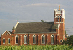
Blakeslee Ohio - St Joseph Catholic Church.jpg
St Joseph Catholic Church in northern Blakeslee
OHMap-doton-Blakeslee.png
Location of Blakeslee, Ohio
Map of Williams County Ohio Highlighting Blakeslee Village.png
Location of Blakeslee in Williams County
Coordinates: 41°31′27″N84°43′51″W / 41.52417°N 84.73083°W / 41.52417; -84.73083
Country United States
State Ohio
County Williams
Government
  Type Village council
Area
[1]
  Total0.09 sq mi (0.24 km2)
  Land0.09 sq mi (0.24 km2)
  Water0.00 sq mi (0.00 km2)
Elevation
[2]
863 ft (263 m)
Population
 (2020)
  Total104
  Density1,106.38/sq mi (425.89/km2)
Time zone UTC-5 (Eastern (EST))
  Summer (DST) UTC-4 (EDT)
ZIP code
43505
Area code 419
FIPS code 39-06810 [3]
GNIS feature ID2398130 [2]

Blakeslee is a village in Williams County, Ohio, United States. The population was 104 at the 2020 census.

Contents

History

Blakeslee was platted in 1880. [4] The village was named for Schuyler E. Blakeslee, a local attorney. [5] A post office has been in operation at Blakeslee since 1880. [6]

Geography

According to the United States Census Bureau, the village has a total area of 0.11 square miles (0.28 km2), all land. [7]

Demographics

Historical population
CensusPop.Note
1900 239
1910 169−29.3%
1920 121−28.4%
1930 14620.7%
1940 16412.3%
1950 142−13.4%
1960 1569.9%
1970 1634.5%
1980 136−16.6%
1990 128−5.9%
2000 1301.6%
2010 96−26.2%
2020 1048.3%
U.S. Decennial Census [8]

2010 census

As of the census [9] of 2010, there were 96 people, 45 households, and 26 families living in the village. The population density was 872.7 inhabitants per square mile (337.0/km2). There were 50 housing units at an average density of 454.5 per square mile (175.5/km2). The racial makeup of the village was 100.0% White.

There were 45 households, of which 28.9% had children under the age of 18 living with them, 48.9% were married couples living together, 8.9% had a female householder with no husband present, and 42.2% were non-families. 37.8% of all households were made up of individuals, and 17.8% had someone living alone who was 65 years of age or older. The average household size was 2.13 and the average family size was 2.85.

The median age in the village was 38 years. 22.9% of residents were under the age of 18; 7.3% were between the ages of 18 and 24; 28.1% were from 25 to 44; 18.8% were from 45 to 64; and 22.9% were 65 years of age or older. The gender makeup of the village was 49.0% male and 51.0% female.

2000 census

As of the census [3] of 2000, there were 130 people, 48 households, and 34 families living in the village. The population density was 1,226.8 inhabitants per square mile (473.7/km2). There were 49 housing units at an average density of 462.4 per square mile (178.5/km2). The racial makeup of the village was 99.23% White and 0.77% Native American. Hispanic or Latino of any race were 0.77% of the population.

There were 48 households, out of which 37.5% had children under the age of 18 living with them, 58.3% were married couples living together, 10.4% had a female householder with no husband present, and 27.1% were non-families. 22.9% of all households were made up of individuals, and 8.3% had someone living alone who was 65 years of age or older. The average household size was 2.71 and the average family size was 3.17.

In the village, the population was spread out, with 33.1% under the age of 18, 9.2% from 18 to 24, 29.2% from 25 to 44, 16.2% from 45 to 64, and 12.3% who were 65 years of age or older. The median age was 29 years. For every 100 females there were 103.1 males. For every 100 females age 18 and over, there were 85.1 males.

The median income for a household in the village was $43,750, and the median income for a family was $45,250. Males had a median income of $32,250 versus $20,000 for females. The per capita income for the village was $16,738. There were no families and 1.7% of the population living below the poverty line, including no under eighteens and 9.1% of those over 64.
Related Research Articles

<span class="mw-page-title-main">Polk, Ohio</span> Village in Ohio, United States

Polk is a village in Ashland County, Ohio, United States. The population was 310 at the 2020 census.

<span class="mw-page-title-main">Neville, Ohio</span> Village in Ohio, United States

Neville is a village in Clermont County, Ohio, United States, along the Ohio River. The population was 87 at the 2020 census.

<span class="mw-page-title-main">Midland, Ohio</span> Village in Ohio, United States

Midland is a village in Clinton County, Ohio, United States. The population was 307 at the 2020 census.

<span class="mw-page-title-main">Nellie, Ohio</span> Village in Ohio, United States

Nellie is a village in Coshocton County, Ohio, United States, along the Walhonding River. The population was 122 at the 2020 census.

<span class="mw-page-title-main">Gordon, Ohio</span> Village in Ohio, United States

Gordon is a village in Darke County, Ohio, United States. The population was 245 at the 2020 census.

<span class="mw-page-title-main">Ithaca, Ohio</span> Village in Ohio, United States

Ithaca is a village in Darke County, Ohio, United States. The population was 81 at the 2020 census.

<span class="mw-page-title-main">Pitsburg, Ohio</span> Village in Ohio, United States

Pitsburg is a village in Monroe Township, Darke County, Ohio, United States. The population was 381 at the 2020 census.

<span class="mw-page-title-main">Sugar Grove, Ohio</span> Village in Ohio, United States

Sugar Grove is a village in Fairfield County, Ohio, United States. The population was 429 at the 2020 census.

<span class="mw-page-title-main">Valleyview, Ohio</span> Village in Ohio, United States

Valleyview is a village in Franklin County, Ohio, United States. The population was 669 at the 2020 census.

<span class="mw-page-title-main">Lyons, Ohio</span> Village in Ohio, United States

Lyons is a village in Fulton County, Ohio, United States. The population was 602 at the 2020 census.

<span class="mw-page-title-main">North Bend, Ohio</span> Village in Ohio, United States

North Bend is a village in Miami Township, Hamilton County, Ohio, United States, along the Ohio River. It is a part of the Greater Cincinnati area. The population was 835 at the 2020 census.

<span class="mw-page-title-main">Jenera, Ohio</span> Village in Ohio, United States

Jenera is a village in Hancock County, Ohio, United States. The population was 257 at the 2020 census. It is surrounded by Van Buren Township and is part of the Cory-Rawson Local School District.

<span class="mw-page-title-main">New Athens, Ohio</span> Village in Ohio, United States

New Athens is a village in Harrison County, Ohio, United States. The population was 222 at the 2020 census.

<span class="mw-page-title-main">Hartford, Ohio</span> Village in Ohio, United States

Hartford is a village in the township of the same name in Licking County, Ohio, United States. The population was 404 at the 2020 census.

<span class="mw-page-title-main">Tarlton, Ohio</span> Village in Ohio, United States

Tarlton is a village in Fairfield and Pickaway counties in the U.S. state of Ohio. The population was 254 at the 2020 census.

<span class="mw-page-title-main">Hartville, Ohio</span> Village in Ohio, United States

Hartville is a village in northern Stark County, Ohio, United States. The population was 3,329 at the 2020 census. It is part of the Canton–Massillon metropolitan area. Hartville lies halfway between Akron and Canton at the intersection of State Routes 43 and 619.

<span class="mw-page-title-main">Limaville, Ohio</span> Census-designated place in Ohio, United States

Limaville is a census-designated place (CDP) and former village in Stark County, Ohio, United States. The population was 151 at the 2020 census. It is part of the Canton–Massillon Metropolitan Statistical Area.

<span class="mw-page-title-main">Midvale, Ohio</span> Village in Ohio, United States

Midvale is a village in Tuscarawas County, Ohio, United States. The population was 673 at the 2020 census.

<span class="mw-page-title-main">Wilkesville, Ohio</span> Village in Ohio, United States

Wilkesville is a village in Vinton County, Ohio, United States. The population was 116 at the 2020 census.

<span class="mw-page-title-main">Clifton, Ohio</span> Village in Ohio, United States

Clifton is a village in Clark and Greene counties in the U.S. state of Ohio and is home to the Clifton Mill, one of the largest water-powered grist mills still in existence. The population was 131 at the 2020 census.

References

  1. "ArcGIS REST Services Directory". United States Census Bureau. Retrieved September 20, 2022.
  2. 1 2 U.S. Geological Survey Geographic Names Information System: Blakeslee, Ohio
  3. 1 2 "U.S. Census website". United States Census Bureau . Retrieved January 31, 2008.
  4. "County Information (Williams County, Ohio)". Archived from the original on February 22, 2014. Retrieved November 3, 2015.
  5. "Blakeslee, Ohio Village Information". Archived from the original on May 14, 2019.
  6. "Williams County". Jim Forte Postal History. Retrieved March 2, 2015.
  7. "US Gazetteer files 2010". United States Census Bureau. Archived from the original on January 25, 2012. Retrieved January 6, 2013.
  8. "Census of Population and Housing". Census.gov. Retrieved June 4, 2015.
  9. "U.S. Census website". United States Census Bureau . Retrieved January 6, 2013.