Amsterdam is the capital and most populated city of the Netherlands. It has a population of 921,402 within the city proper, 1,457,018 in the urban area and 2,480,394 in the metropolitan area. Located in the Dutch province of North Holland, Amsterdam is colloquially referred to as the "Venice of the North", for its large number of canals, now a UNESCO World Heritage Site.

Amstelveen is a municipality and city in the province of North Holland, Netherlands, with a population of 92,353 as of 2022. It is a suburban part of the Amsterdam metropolitan area.

The Amstel is a river in the province of North Holland in the Netherlands. It flows from the Aarkanaal and Drecht in Nieuwveen northwards, passing Uithoorn, Amstelveen, and Ouderkerk aan de Amstel, to the IJ in Amsterdam, to which the river gives its name. Annually, the river is the location of the Liberation Day concert, Head of the River Amstel rowing match, and the Amsterdam Gay Pride boat parade.

Amsterdam has a long and eventful history. The origins of the city lie around 1000 CE, when inhabitants settled at the mouth of the Amstel and began peatland reclamation. After the All Saints' Flood (1170), a dam was built in the Amstel to protect the lower lands from floods.

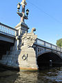
The Magere Brug is a bridge over the river Amstel in Amsterdam, Netherlands. It connects the banks of the river at Kerkstraat, between the Keizersgracht and Prinsengracht.

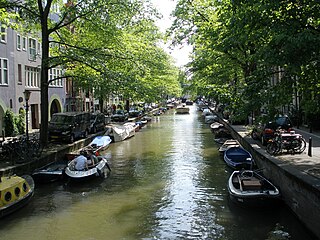
The Singel is one of the canals of Amsterdam. The Singel encircled Amsterdam in the Middle Ages, serving as a moat around the city until 1585, when Amsterdam expanded beyond the Singel. The canal runs from the IJ bay, near the Central Station, to the Muntplein square, where it meets the Amstel river. It is now the inner-most canal in Amsterdam's semicircular ring of canals.

Rembrandtplein is a major square in central Amsterdam, Netherlands, named after Rembrandt van Rijn who owned a house nearby from 1639 to 1656.

The coat of arms of Amsterdam is the official coat of arms symbol of the city of Amsterdam. It consists of a red shield and a black pale with three silver Saint Andrew's Crosses, the Imperial Crown of Austria, two golden lions, and the motto of Amsterdam. Several heraldic elements have their basis in the history of Amsterdam. The crosses and the crown can be found as decorations on different locations in the city.
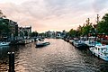
Amsterdam, capital of the Netherlands, has more than 100 kilometers (62 mi) of grachten (canals), about 90 islands and 1,500 bridges. The three main canals, dug in the 17th century during the Dutch Golden Age, form concentric belts around the city, known as the Grachtengordel. Alongside the main canals are 1550 monumental buildings. The 17th-century canal ring area, including the Prinsengracht, Keizersgracht, Herengracht and Jordaan, were listed as UNESCO World Heritage Site in 2010, contributing to Amsterdam's fame as the "Venice of the North".
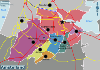
Amstelland is the area along the river Amstel in the Netherlands, beginning in South Holland and running north towards Amsterdam in southern North Holland.
Omval is a neighbourhood situated on a peninsula on the eastern shore of the Amstel river in Amsterdam, Netherlands. It is situated south of the Weesperzijde neighbourhood and next to the Amsterdam Amstel railway station in the borough of Amsterdam-Oost. In the 1990s, it became the site of a major business district featuring the Rembrandt Tower, the tallest skyscraper in Amsterdam.

Rivierenbuurt is a neighbourhood of Amsterdam, Netherlands. The neighbourhood is situated in the eastern part of the borough of Amsterdam-Zuid, bordered by the river Amstel to the east, the Boerenwetering canal in the west, the Amstelkanaal in the north and the A10 motorway in the south. In 2013, the Rivierenbuurt had approximately 28,400 residents.

Schinkelbuurt is a little neighborhood of Amsterdam, Netherlands. It is located directly south of Amsterdam's city centre and it is part of the borough Amsterdam-Zuid, in the part of the city known as the "Old South".

The Korenbeurs was a 17th-century commodity market in Amsterdam where grain was traded. The building stood on the banks of the Amstel, on the western side (Nieuwezijde) of the Damrak. It was directly south of the Oude Brug bridge, on a spot now occupied by the former stock and commodity exchange Beurs van Berlage.

Lijnbaansgracht is a partly filled-in canal in Amsterdam which bends beyond the boundary of the center, Amsterdam-Centrum. The canal runs parallel to the Singelgracht, between the Brouwersgracht and the Reguliersgracht.
The Groenburgwal is a canal in Amsterdam that connects the Raamgracht with the Amstel. The Groenburgwal is parallel to the Kloveniersburgwal and the Zwanenburgwal, in the shadow of the tower of the Zuiderkerk.
The Leprozengracht was a canal in Amsterdam that defined one side of the Vlooienburg island. Leprozengracht and the connected Houtgracht canal were filled in 1882 to form the Waterlooplein.

The Berlagebrug is a bascule bridge over the river Amstel in Amsterdam, Netherlands. The bridge was commissioned by the Amsterdam municipality and designed by engineer Cornelis Biemond (1899-1980) and architect Hendrikus Petrus Berlage (1856–1934); it was named after the latter. It was constructed from 1926 to 1931 and officially opened on 28 May 1932. It has been designated as a Rijksmonument since 11 May 2008. The bridgekeeper's house carries the address Amsteldijk 134.
Vlooienburg or Vloonburg was a filled-in island in the Amstel river on the site of the Stopera in Amsterdam. In the seventeenth century, a lively migrant neighborhood emerged here with timber traders, Jewish merchants from the Mediterrean, kosher shopkeepers, and craftsmen, etc. The island formed the core area of Amsterdam's Jewish Quarter until the destruction in the twentieth century.