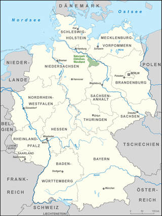
The Palatinate, or the Rhenish Palatinate (Rheinpfalz), is a historical region of Germany. Prior to World War II, it was also referred to as Rhenish Bavaria; as a state of the Holy Roman Empire, it was known as the Lower Palatinate (Unterpfalz), which designated only the western part of the Electorate of the Palatinate, as opposed to the Upper Palatinate (Oberpfalz). It occupies roughly the southernmost quarter of the German federal state of Rhineland-Palatinate (Rheinland-Pfalz), covering an area of 2,105 square miles (5,450 km2) with about 1.4 million inhabitants. Its residents are known as Palatines (Pfälzer).

The Rhön Mountains are a group of low mountains in central Germany, located around the border area where the states of Hesse, Bavaria and Thuringia come together. These mountains, which are at the extreme southeast end of the East Hesse Highlands, are partly a result of ancient volcanic activity. They are separated from the Vogelsberg Mountains by the river Fulda and its valley. The highest mountain in the Rhön is the Wasserkuppe, which is in Hesse. The Rhön Mountains are a popular tourist destination and walking area.
UNESCO Biosphere Reserves are environment-protected scientific-research institutions of international status that are created with the intent for conservation in a natural state the most typical natural complexes of biosphere, conducting background ecological monitoring, studying of the surrounding natural environment, its changes under the activity of anthropogenic factors.

Homburg is a town in Saarland, Germany and the administrative seat of the Saarpfalz district. With a population of 43,029 inhabitants (2022), it is the third largest town in the state. The city offers over 30,000 workplaces. The medical department of the University of Saarland is situated here. The city is also home to the Karlsberg beer brewery. Major employers include Robert Bosch GmbH, Schaeffler Group and Michelin.

Dillingen is a town in the district of Saarlouis, in Saarland. It has about 20,000 inhabitants and is divided into the three districts Dillingen-city center, Pachten and Diefflen. The city is located on the edge of the Saar-Hunsrück Nature Park at the mouth of the Prims in the Saar and is located about 10 km from the French border. Dillingen is located about 60 km from Luxembourg City and Trier, 50 km from Metz and 30 km from Saarbrücken and is directly adjacent to the urban area of Saarlouis. In terms of population, it is the second largest municipality in the district of Saarlouis. The Dillinger Hütte steelworks is located here.
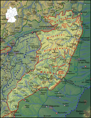
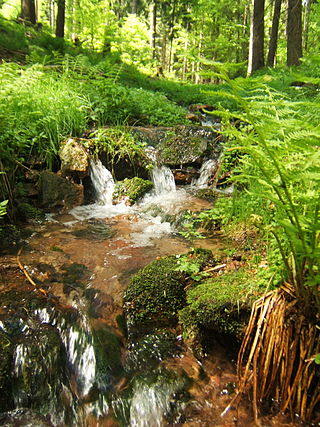
The Palatinate Forest, sometimes also called the Palatine Forest, is a low-mountain region in southwestern Germany, located in the Palatinate in the state of Rhineland-Palatinate. The forest is a designated nature park covering 1,771 km2 and its highest elevation is the Kalmit.

Blieskastel is a city in the Saarpfalz (Saar-Palatinate) district, in Saarland, Germany which is divided into villages. It is situated on the river Blies, approximately 10 kilometres southwest of Homburg (Saar), 8 km (5 mi) west of Zweibrücken, and 20 km (12 mi) east of Saarbrücken.
The municipal district of Einöd is a quarter (Stadtteil) of the city of Homburg and with it part of Saarpfalz-Kreis in Saarland. It includes three municipal fractions: Einöd, Ingweiler and Schwarzenacker. In 2021, Einöd had 3,392 inhabitants.
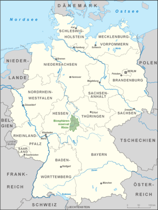
The Rhön Biosphere Reserve includes the entire central area of the Rhön Mountains, a low mountain range in the German states of Hesse, Bavaria and Thuringia.

The Südheide Nature Park is a large protected area of forest and heathland in the southern part of the Lüneburg Heath in North Germany. It has been designated as a protected nature park since 1964.
The Kruger to Canyons Biosphere Region is a biosphere reserve situated in the north eastern region of South Africa, straddling Limpopo and Mpumalanga Provinces. In 2001, under the supervision of the then Department of Environmental Affairs (DEA), the Kruger to Canyons Biosphere Region was officially ratified by UNESCO as part of the Man and the Biosphere (MaB) Programme. UNESCO's Man and the Biosphere Programme provides a framework for exploring local solutions to challenges by mainstreaming biodiversity conservation and sustainable development, integrating economic, social and environmental aspects and recognizing their vital linkages within specific learning landscapes adjacent to Protected Areas.

The Palatinate Forest Nature Park lies in the south of Rhineland-Palatinate in Germany and borders on France. The nature park covers an area of 177,100 hectares (684 sq mi) and some 76% of its area is under the woods of the Palatinate Forest, the largest contiguous forest region in Germany. Together with parts of northern Alsace and Lorraine, it forms the Palatinate Forest-North Vosges Biosphere Reserve and has an impressive Bunter sandstone landscape.

The Aukrug Nature Park is a nature park in north Germany with an area of 380 square kilometres (150 sq mi). It lies in the centre of the state of Schleswig-Holstein in the region of Holstein. It is sponsored by an association formed by the 2 districts.

The Saargau was a Frankish Gau county (Gaugrafschaft). Today the name is given to the ridge between the rivers Saar and Moselle in Germany and, in the south, the region between the Saar and the French border.
The Vessertal-Thüringen Forest forms a central part of the much larger Thuringian Forest.

The East Vättern Scarp LandscapeBiosphere Reserve is a UNESCO Biosphere Reserve in Sweden. The 105,520 hectares (407.4 sq mi) reserve is a distinct example of the landscape in the central part of southern Sweden. The East Vättern Scarp Landscape contains many parallel fault scarps, most notably a steep western-facing precipice above the eastern border of Lake Vättern. This rugged landscape, cut by many small waterways, is dominated by agriculture and forestry lands, with villages and settlements consisting of small farms and individual homes. The reserve includes portions of Vättern and other deep lakes. The core area is 2,120 hectares (8.2 sq mi), surrounded by buffer zone(s) of 41,800 hectares (161 sq mi) and transition area(s) of 61,600 hectares (238 sq mi).
The Bogeda Biosphere Reserve, also known in English as Bogda Biosphere Reserve, is located in the eastern region of the Tianshan Mountains in China's Xinjiang Province. Local residents named the area the Sangong River Valley after one of the largest rivers in this region, which originates from Bogda Peak. Altogether, five major landscapes are distributed throughout the northern and southern areas of the biosphere reserve: ice-snow belts, alpine and sub-alpine meadow belts, forest belts, steppe belts and sand desert dunes. The topography consists of a middle mountain belt, low mountain erosion hills and alluvial areas. Tianchi Lake is the only natural lake in the region and lies adjacent to the Sangong River.

Bierbach an der Blies is a part (Stadtteil) of Blieskastel, Saarland, Germany. It is part of the Bliesgau and was founded on the right river bank of the Blies. As a consequence of the territorial and administrative reform of 1974 in Saarland, Bierbach ceased to be an independent municipality and became a part of the town of Blieskastel and incorporated within the district Saarpfalz-Kreis of which Homburg is the administrative seat.

The West Polesie Transboundary Biosphere Reserve is a transboundary nature reserve located in Poland, Ukraine, and Belarus. It is designated as an area of global importance under UNESCO's World Network of Biosphere Reserves under their Programme on Man and the Biosphere.