Related Research Articles

Saint Kitts and Nevis, officially the Federation of Saint Christopher and Nevis, is an island country consisting of the two islands of Saint Kitts and Nevis, both located in the West Indies, in the Leeward Islands chain of the Lesser Antilles. With 261 square kilometres (101 sq mi) of territory, and roughly 48,000 inhabitants, it is the smallest sovereign state in the Western Hemisphere, in both area and population, as well as the world's smallest sovereign federation. The country is a Commonwealth realm, with Charles III as King and head of state.
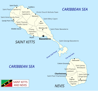
Saint Kitts and Nevis is a twin island country with a total landmass of just 270 square kilometres (104 sq mi). The island of St. Kitts, the larger of the two, is 180 square kilometres (68 sq mi) in size and is located at latitude 17.30 N, and longitude 62.80 W. Nevis is 93 square kilometres (36 sq mi) and located at latitude 17.10 N, longitude 62.35 W, approximately 3 km south-east of St. Kitts. The islands are about one-third of the way from Puerto Rico to Trinidad and Tobago. The islands are volcanic and mountainous.

Basseterre is the capital and largest city of Saint Kitts and Nevis with an estimated population of 14,000 in 2018. Geographically, the Basseterre port is located at 17°18′N62°44′W, on the south-western coast of Saint Kitts Island, and it is one of the chief commercial depots of the Leeward Islands. The city lies within Saint George Basseterre Parish.

Saint Christopher-Nevis-Anguilla was a British colony in the West Indies from 1882 to 1983, consisting of the islands of Anguilla, Nevis, and Saint Christopher. From 1882 to 1951, and again from 1980, the colony was known simply as Saint Christopher and Nevis. Saint Christopher and Nevis gained independence in 1983 as the Federation of Saint Kitts and Nevis, while Anguilla would remain a British overseas territory.

Saint Anne Sandy Point is one of 14 administrative parishes that make up Saint Kitts and Nevis. It is the smallest parish on St. Kitts in terms of area, at just 5 square miles (13 km2). It is located on the main island of Saint Kitts and the parish capital is Sandy Point Town.
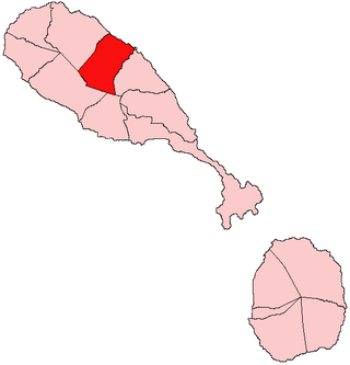
Christ Church Nichola Town is one of 14 administrative parishes that make up Saint Kitts and Nevis. Christ Church Nichola Town is the fifth largest parish on Saint Kitts and is located on the east coast of the main island of Saint Kitts. The parish capital is Nichola Town and its largest town is Molyneux.
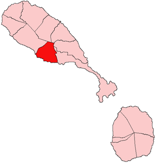
Trinity Palmetto Point is one of 14 administrative parishes that make up Saint Kitts and Nevis. It ranks 6th in terms of size of all the parishes on Saint Kitts. The parish capital is Trinity.
Area code 869 is the local telephone area code of Saint Kitts and Nevis. The 869 area code was created during a split from the original (809) area code which began permissive dialing on 1 October 1996 and ended 31 March 1997.
Fort Charles, also called Cleverley Point Fort, is a historic British colonial fort site on the island of St. Kitts, located in the present day nation of Saint Kitts and Nevis in the Caribbean.

Sandy Point is the second largest town in the island of Saint Kitts, Saint Kitts and Nevis. This town is situated on the north-west coast of St. Kitts and is the capital of Saint Anne Sandy Point Parish.

The Kalinago genocide was the genocidal massacre of an estimated 2,000 Kalinago people by English and French settlers on the island of Saint Kitts in 1626.
Bloody River or Stone Fort River is a river or ghaut in Saint Kitts which starts from the South East Range, flows west of the village of Challengers and exits at Bloody Point.
The Great Salt Pond is the largest lake within Saint Kitts and Nevis.

Black Rocks, also called Black Stone, is the name of a rock formation on the northeastern coast of the island of Saint Kitts. Located close to the town of Saddlers, the rocks consist of lava flow from the volcanic Mount Liamuiga which dominates the northern half of the island of Saint Kitts.

The Battle of St. Kitts or St. Cristopher was a successful Spanish expedition that seized the islands of Saint Kitts and Nevis from the English and French during the Anglo-Spanish War (1625–30).
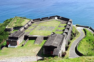
The French invasion of Saint Kitts also known as the siege of Brimstone Hill, from 19 January–13 February 1782, was a part of the American Revolutionary War. After landing on Saint Kitts, the French troops of the Marquis de Bouillé stormed and besieged the fortress of Brimstone Hill. After a month of battle, the heavily outnumbered and cut-off British garrison surrendered. The Comte de Grasse, who delivered de Bouillé's troops and supported the siege, was outmanoeuvred and deprived of his anchorage by Admiral Samuel Hood. Even though Hood's force was inferior by one-third, de Grasse was beaten off when he attempted to dislodge Hood. Hood's attempts to relieve the ongoing siege were unsuccessful, and the garrison capitulated after one month. About a year later, the Treaty of Paris restored Saint Kitts and adjacent Nevis to British rule.
The Ministry of Foreign Affairs is the ministry responsible for handling the Federation of Saint Kitts and Nevis' external relations and its diplomatic missions abroad. The ministry's current director is Minister of Foreign Affairs and Aviation, Denzil Douglas.

The Basilica of San Martiño de Mondoñedo is a church in the municipality of Foz in Galicia (Spain). It is considered the oldest cathedral in Spain; it was the seat of two bishops in the ninth century.
References
- ↑ Lea, David; Colette Milward; Annamarie Rowe (2001). A Political Chronology of the Americas. Routledge. p. 181. ISBN 1-85743-118-9.
- ↑ Hubbard, Vincent (2002). A History of St. Kitts . Macmillan Caribbean. p. 17-18. ISBN 9780333747605.
17°18′12″N62°47′19″W / 17.3033°N 62.7885°W
| | This Saint Kitts and Nevis location article is a stub. You can help Wikipedia by expanding it. |