Bloomfield Track

Last updated

Bloomfield Track

BloomfieldTrack09.jpg
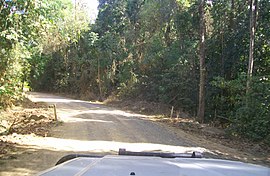
Driving along the Bloomfield Track, September 2009
Bloomfield Track
General information
TypeRural road
Length30 km (19 mi)
Opened1984
Major junctions
North end Wujal Wujal
South end Cape Tribulation

The Bloomfield Track, which is also known as the Coast Road or officially, the Cape Tribulation-Bloomfield Road, is a controversial four-wheel-drive road in Far North Queensland, Australia. The road's construction through untouched wilderness was the cause of protests and blockades in the early 1980s. [1]

Contents

The road was completed in 1984, connecting Cape Tribulation to Cooktown. This route is an alternative to the Mulligan Highway further inland. [2] It passes over the Donovan and Cowie Ranges. [3] To reduce the environment impact the road was designed with few switchbacks and bends on the climbs resulting in patches of steep gradients over the ranges. [3] The track itself is 30 km in length.[ citation needed ]

The road is only partially sealed and may be impassable after heavy rains. Access to Bloomfield Falls and the aboriginal community of Wujal Wujal is provided by the road which also crosses the Bloomfield River. Tourism along the Bloomfield Track has been popular. Visitors are drawn to the pristine rainforest, swimming holes, creeks and beaches. [4]

Access

The track begins at Cape Tribulation and winds its way north through the Daintree Rainforest, crossing many creeks in the process; then it ends at the aboriginal community Wujal Wujal. Many local authorities recommend that the journey should be undertaken in a four-wheel-drive vehicle, however recent upgrades have been undertaken (including the construction of bridges at the Bloomfield River and Woobooda Creek crossings in 2014/15, as well as paving works on the Cowie and Donovan Ranges) that make the road more suitable for some two-wheel-drive vehicles, provided that they are driven with care in dry weather only.

Protests

Douglas Shire Council and the Government of Queensland supported the road's development. [5] Environmentalists opposed the road on the basis that it would bring unwanted development to an area of high environmental significance. Blockades against bulldozers brought police and arrests were made. [1] [6] This resulted in national and international attention to the issue. [5] The campaign to protect the Daintree Rainforest through which the road passed eventually resulted in the area being declared a World Heritage Site. The Queensland Government opposed the World Heritage listing. It took the issue to the High Court of Australia to stop it but was unsuccessful. [5]

See also

Related Research Articles

<span class="mw-page-title-main">Daintree National Park</span> Protected area in Queensland, Australia

The Daintree rainforest is a national park in Far North Queensland, Australia, 1,757 km (1,092 mi) northwest of Brisbane and 100 km (62 mi) northwest of Cairns. It was founded in 1981 and is part of the Wet Tropics of Queensland. In 1988 it became a World Heritage Site. The park consists of two sections, with a settled agricultural area between them which includes the towns of Mossman and Daintree Village.

<span class="mw-page-title-main">Daintree, Queensland</span> Town in Queensland, Australia

Daintree is a rural town and locality in the Shire of Douglas, Queensland, Australia. In the 2016 census, Daintree had a population of 129 people.

<span class="mw-page-title-main">Daintree Rainforest</span> Rainforest in the region of the Daintree River, Australia

The Daintree Rainforest is a region on the northeast coast of Queensland, Australia, north of Mossman and Cairns. At around 1,200 square kilometres (460 sq mi), the Daintree is a part of the largest continuous area of tropical rainforest on the Australian continent. The Daintree Rainforest is a part of the Wet Tropics of Queensland Rainforest, that spans across the Cairns Region. The Wet Tropics Rainforest is the oldest continually surviving tropical rainforest in the world. Along the coastline north of the Daintree River, tropical forest grows right down to the edge of the sea.

<span class="mw-page-title-main">Wujal Wujal</span> Town in Queensland, Australia

Wujal Wujal is a rural town and locality in the Wujal Wujal Aboriginal Shire, Queensland, Australia. In the 2016 census, Wujal Wujal had a population of 282 people. It is an Aboriginal community.

<span class="mw-page-title-main">Daintree River</span> River in Queensland, Australia

The Daintree River is a river that rises in the Daintree Rainforest near Cape Tribulation in Far North Queensland, Australia. The river is located about 100 kilometres (62 mi) northwest of Cairns in the UNESCO World Heritage–listed Wet Tropics of Queensland. The area is now primarily a tourist attraction.

<span class="mw-page-title-main">Maytown, Queensland</span> Historic site in Queensland, Australia

Maytown was the main township on the Palmer River goldfields in Far North Queensland, Australia. It is now a ghost town within locality of Palmer in the Shire of Cook, having been active from c. 1874 to the 1920s. It was added to the Queensland Heritage Register on 1 June 2004.

<span class="mw-page-title-main">Cape Tribulation, Queensland</span> Suburb of Shire of Douglas, Queensland, Australia

Cape Tribulation is a headland and coastal locality in the Shire of Douglas in northern Queensland, Australia. In the 2016 census, Cape Tribulation had a population of 118 people.

<span class="mw-page-title-main">Far North Queensland</span> Region in Queensland, Australia

Far North Queensland (FNQ) is the northernmost part of the Australian state of Queensland. Its largest city is Cairns and it is dominated geographically by Cape York Peninsula, which stretches north to the Torres Strait, and west to the Gulf Country. The waters of Torres Strait include the only international border in the area contiguous with the Australian mainland, between Australia and Papua New Guinea.

<span class="mw-page-title-main">North Queensland</span> Region in Queensland, Australia

North Queensland or the Northern Region is the northern part of the Australian state of Queensland that lies just south of Far North Queensland. Queensland is a massive state, larger than many countries, and its tropical northern part has been historically remote and undeveloped, resulting in a distinctive regional character and identity.

<span class="mw-page-title-main">Palmer River</span> River in Queensland, Australia

The Palmer River is a river located in Far North Queensland, Australia. The area surrounding the river was the site of a gold rush in the late 19th century which started in 1873.

<span class="mw-page-title-main">Mossman, Queensland</span> Town in Queensland, Australia

Mossman is a rural town and locality in the Shire of Douglas, Queensland, Australia. It is the administrative centre for the Douglas Shire Council In the 2016 census, the locality of Mossman had a population of 1,937 people.
<span class="mw-page-title-main">Shire of Douglas</span> Local government area in Queensland, Australia

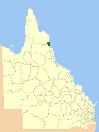
The Shire of Douglas is a local government area in Far North Queensland. It is located on the coast north of the city of Cairns. The shire, administered from the town of Mossman, covers an area of 2,428 square kilometres (937.5 sq mi), and existed as a local government entity from 1880 until 2008, when it was amalgamated with the City of Cairns to become the Cairns Region. Following a poll in 2013, the Shire of Douglas was re-established on 1 January 2014.

<span class="mw-page-title-main">Shire of Cook</span> Local government area in Queensland, Australia

The Shire of Cook is a local government area in Far North Queensland, Australia. The Shire covers most of the eastern and central parts of Cape York Peninsula, the most northerly section of the Australian mainland.

<span class="mw-page-title-main">Bloomfield River</span> River in Far North Queensland, Australia

The Bloomfield River is a river located in the Wet Tropics of Far North Queensland, Australia, noted for its Bloomfield River cod fish species, found only in the river.

<span class="mw-page-title-main">Bloomfield Falls</span> Waterfall in Daintree National Park in Queensland, Australia

The Bloomfield Falls is a cascade waterfall on the Bloomfield River near Cape Tribulation, close to Wujal Wujal, that is located in the UNESCO World Heritage–listed Daintree National Park in Queensland, Australia.

<span class="mw-page-title-main">Wujal Wujal Aboriginal Shire</span> Local government area in Queensland, Australia

The Wujal Wujal Aboriginal Shire is a local government area in Far North Queensland, Australia. It is managed as a Deed of Grant in Trust under the Local Government Act 2004.

<span class="mw-page-title-main">Bloomfield, Queensland</span> Suburb of Shire of Cook, Queensland, Australia

Bloomfield is a town in the Shire of Cook and a coastal locality which is split between the Shire of Cook and the Shire of Douglas in Queensland, Australia. The neighbourhood of Ayton is within the locality. In the 2016 census, Bloomfield had a population of 204 people.

<span class="mw-page-title-main">Palmer, Queensland</span> Suburb of Shire of Cook, Queensland, Australia

Palmer is a rural locality in the Shire of Cook, Queensland, Australia.

<span class="mw-page-title-main">Mossman River</span> River in Far North Queensland, Australia

The Mossman River is a river located in the Cape York Peninsula of Far North Queensland, Australia.

Mount Mulgrave is a rural locality in the Shire of Mareeba, Queensland, Australia. In the 2016 census, Mount Mulgrave had a population of 0 people.
References

  1. 1 2 Mounter, Brendan; Staley, Phil (25 December 2018). "Wet Tropics — how Queensland's Daintree rainforest was saved". ABC Far North. Australian Broadcasting Corporation . Retrieved 27 December 2018.
  2. Lee Mylne (21 September 2009). "The new rush". News.com.au. News Corp Australia Network. Retrieved 31 July 2017.
  3. 1 2 "The end of the road". Brisbane Times . Fairfax Digital. 21 June 2008. Retrieved 15 November 2009.
  4. "Coast Road". Cook Shire Council. Archived from the original on 13 September 2009. Retrieved 16 November 2009.
  5. 1 2 3 "Daintree Blockade". DaintreeCoast.com. Archived from the original on 26 November 2009. Retrieved 16 November 2009.
  6. Wilkie, Bill (2017). The Daintree Blockade. Australia: Four Mile Books. pp. 88–307. ISBN   978-0994631800.

Coordinates: 15°51′27.64″S145°19′35.65″E / 15.8576778°S 145.3265694°E / -15.8576778; 145.3265694