Erie County is a county located in the northern portion of the U.S. state of Ohio. As of the 2020 census, the population was 75,622. Its county seat and largest city is Sandusky. The county is named for the Erie tribe, whose name was their word for "wildcat". It was formed in 1838 from the northern third of Huron County and a portion of Sandusky County.

Erie Township is a civil township of Monroe County in the U.S. state of Michigan. The population was 4,299 at the 2020 census. Sharing a southern border with the city of Toledo about 35 miles (56.3 km) south of the city of Detroit, the township is one of the southernmost areas included in the Detroit–Warren–Ann Arbor Combined Statistical Area.
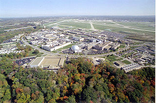
NASA John H. Glenn Research Center at Lewis Field is a NASA center within the cities of Brook Park and Cleveland between Cleveland Hopkins International Airport and the Rocky River Reservation of Cleveland Metroparks, with a subsidiary facility in Sandusky, Ohio. Its director is James A. Kenyon. Glenn Research Center is one of ten major NASA facilities, whose primary mission is to develop science and technology for use in aeronautics and space. As of May 2012, it employed about 1,650 civil servants and 1,850 support contractors on or near its site.

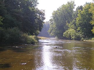
The Huron River is a 14.9-mile-long (24.0 km) waterway in the north central Ohio in the United States. The watershed drains large portions of Erie County and Huron County, the northeast corners of Seneca County and Crawford County, and northern portions of Richland County.

The Warren County Canal was a branch of the Miami and Erie Canal in southwestern Ohio about 20 miles (32 km) in length that connected the Warren County seat of Lebanon to the main canal at Middletown in the mid-19th century. Lebanon was at the crossroads of two major roads, the highway from Cincinnati to Columbus and the road from Chillicothe to the College Township (Oxford), but Lebanon businessmen and civic leaders wanted better transportation facilities and successfully lobbied for their own canal, part of the canal fever of the first third of the 19th century. The Warren County Canal was never successful, operating less than a decade before the state abandoned it.

South Bass Island is a small island in western Lake Erie, and a part of Ottawa County, Ohio, United States. It is the southernmost of the three Bass Islands and located 3 miles (4.6 km) from the south shore of Lake Erie. It is the third largest island in the Lake Erie Islands, and is part of Put-in-Bay Township. In the bay of South Bass is Gibraltar Island, home to the Ohio State University's Stone Laboratory.
Summit Metro Parks is a Metroparks system serving the citizens of Summit County, Ohio by managing 14,000 acres (5,700 ha) in 16 developed parks, six conservation areas and more than 150 miles (240 km) of trails, with 22.4 miles (36.0 km) of the Ohio & Erie Canal Towpath Trail.
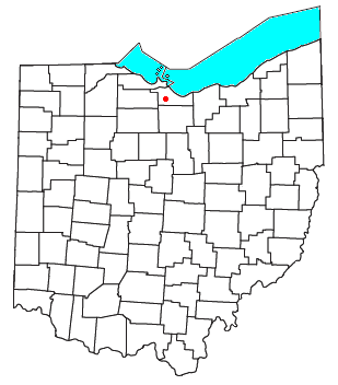
Oxford Township is one of the nine townships of Erie County, Ohio, United States. It is part of the Sandusky, Ohio micropolitan statistical area and the Cleveland-Akron-Canton Combined Statistical Area. The 2020 census recorded 1,140 residents.

Danbury Township is one of the twelve townships of Ottawa County, Ohio, United States. The 2020 census found 4,924 people in the township.

Put-in-Bay Township is one of the twelve townships of Ottawa County, Ohio, United States. The 2020 census found 813 people in the township.

The Pennsylvania and Ohio Canal, also known as the P & O Canal, the Cross Cut Canal and the Mahoning Canal, was a shipping canal which operated from 1840 until 1877, though the canal was completely abandoned by 1872. It connected canals in two states, the Ohio and Erie Canal in Ohio and the Beaver and Erie Canal in Pennsylvania, and was funded by private interests.

Birmingham is an unincorporated community in eastern Florence Township, Erie County, Ohio, United States. It is part of the Sandusky Metropolitan Statistical Area. It is located at the intersection of State Routes 60 and 113.
Erie MetroParks was formed as the "Erie County Metropolitan Park District" in 1968 and adopted its current name in 1991. It consists of 14 individual park areas located throughout Erie County in the US state of Ohio covering approximately 3,200 acres (1,300 ha).
Wind power in Ohio has a long history, and as of 2016, Ohio had 545 megawatts (MW) of utility-scale wind power installations installed, responsible for 1.1% of in-state electricity generated. Over 1000 MW more were under construction or pending approval. Some installations have become tourist attractions. There has been a sudden increase in generating capacity, as total wind power capacity in the state was just 9.7 MW in 2010. By 2019, there were 738 MW of capacity, which generated 1.71% of Ohio's electricity.
Bogart is an unincorporated community in eastern Perkins Township, south of Sandusky, in Erie County, Ohio, United States. It is centered on the intersection of Bogart Road and U.S. Route 250, 1,500 feet south of the State Route 2 interchange with US 250. The center of Bogart is also 1,500 feet west of the boundary between Perkins and Huron townships. Bogart is pronounced locally boh-girt. It is part of the Sandusky Metropolitan Statistical Area.

The Spacecraft Propulsion Research Facility, now known as the In-Space Propulsion Facility, is, the "world’s only facility capable of testing full-scale upper-stage launch vehicles and rocket engines under simulated high-altitude conditions." The facility, located at NASA's Plum Brook Station of the Glenn Research Center near Sandusky, Ohio, was built in 1968. Its first major use was for testing stages of the Centaur Rocket, which was used to launch some of America's most important space probes. The facility was designated a National Historic Landmark in 1985.

Hunts Corners is an unincorporated community in southeastern Lyme Township, Huron County, Ohio, United States. It lies at the intersection of State Route 547 and Sand Hill Road, southeast of Bellevue and southwest of the city of Norwalk, the county seat of Huron County. Its elevation is 768 feet (234 m), and it is located at 41°13′39″N82°45′27″W.
Portage Center is an unincorporated community in Hancock County, in the U.S. state of Ohio.
Millbrook is an unincorporated community in Wayne County, in the U.S. state of Ohio.