Bloop

Last updated

A spectrogram of Bloop Bloop.jpg
A spectrogram of Bloop

Bloop was an ultra-low-frequency, high amplitude underwater sound detected by the U.S. National Oceanic and Atmospheric Administration (NOAA) in 1997. [1] By 2012, earlier speculation that the sound originated from a marine animal [2] was replaced by NOAA's description of the sound as being consistent with noises generated via non-tectonic cryoseisms originating from glacial movements such as ice calving, or through seabed gouging by ice. [1] [3] [4]

Contents

Sound profile

The sound's source was roughly triangulated to 50°S100°W / 50°S 100°W / -50; -100 , a remote point in the South Pacific Ocean west of the southern tip of South America. The sound was detected by the Equatorial Pacific Ocean autonomous hydrophone array, [1] a system of hydrophones primarily used to monitor undersea seismicity, ice noise, and marine mammal population and migration. [5] :284 This is a stand-alone system designed and built by NOAA's Pacific Marine Environmental Laboratory (PMEL) to augment NOAA's use of the U.S. Navy Sound Surveillance System (SOSUS), which was equipment originally designed to detect Soviet submarines. [5] :255–256

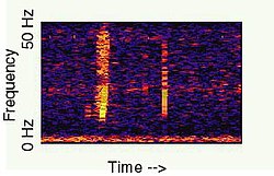
According to the NOAA description, the sound "rose" in frequency over about one minute and was of sufficient amplitude to be heard on multiple sensors, at a range of over 5,000 km (3,000 mi).

Ice quake origin

The NOAA Vents Program has attributed the sound to that of a large cryoseism (also known as an ice quake). [4] Numerous ice quakes share similar spectrograms with Bloop, as well as the amplitude necessary to detect them despite ranges exceeding 5,000 km (3,000 mi). This was found during the tracking of iceberg A53a as it disintegrated near South Georgia Island in early 2008. The iceberg(s) involved in generating the sound were most likely between Bransfield Strait and the Ross Sea; or possibly at Cape Adare, a well-known source of cryogenic signals. [1] Sounds generated by ice quakes are easily determined through the use of hydrophones since seawater, an excellent sound channel, allows the ambient sounds generated through ice activities to travel great distances. [6] :5

Ice calving

In ice calving, variations result from a sound source's motion. [6] :55 As oceanographer Yunbo Xie explains, the alteration of waveforms from a detected sound "can also be caused by so-called angular frequency dependent radiation patterns associated with antisymmetric mode motion of the ice cover." [6] :59

Rubbing and ridging events within an ice floe

Two processes known as rubbing and ridging are responsible for acoustical emissions similar to those from ice calving. [7] Rubbing involves two or more areas of compacted glacial ice floes which are being forced together, inducing shear deformation at its edges and triggering horizontally-polarized shear waves, i. e. SH waves . [6] :137 Ridging occurs when that ice bends or slides at the ridges. [6] :121 According to Xie, both events will produce sound in the failure sequence (breakup) of an ice floe:

"A wave equation resulting from shear deformation will be defined in an ice floe with the rubbing effect coupled to the floe through its boundary with the adjacent ice," [6] :137 while "ridging deformation(s) revealed by this event indicate that the failure process is associated with a crushing process that seals air or vacuous gaps between ice floes. The acoustical signals emitted by this failure process are similar to those emitted from a collapsing air bubble in a fluid." [6] :121

Animal origin

NOAA's Christopher Fox, in an interview with CNN in 2001, stated that he believed Bloop to be ice calving in Antarctica. [8] In 2002, Fox was interviewed by David Wolman for an article in New Scientist , where he stated that he did not believe its origin was man-made, such as a submarine or bomb. Fox also stated that while the audio profile of Bloop does resemble that of a living creature, [2] the source was a mystery because it would be "far more powerful than the calls made by any animal on Earth." [9] Wolman reported in his article the following:

Fox's hunch is that the sound nicknamed Bloop is the most likely (out of the other recorded unidentified sounds) to come from some sort of animal, because its signature is a rapid variation in frequency similar to that of sounds known to be made by marine beasts. There's one crucial difference, however: in 1997 Bloop was detected by sensors up to 4,800 km (3,000 mi) apart. That means it must be far louder than any whale noise, or any other animal noise for that matter. Is it even remotely possible that some creature bigger than any whale is lurking in the ocean depths? Or, perhaps more likely, something that is much more efficient at making sound? [10] :174–175

David Wolman

According to author Philip Hayward, Wolman's speculations "amplified Fox's 'hunch' and—through the use of the word 'likely'—opened the door for subsequent speculation as to what such an 'efficient' noise-making entity might be. Over the last decade, consensus has supported the argument that the noise is produced by ice fracturing processes." [10] :175

See also

Related Research Articles

<span class="mw-page-title-main">Sonar</span> Acoustic sensing method

Sonar is a technique that uses sound propagation to navigate, measure distances (ranging), communicate with or detect objects on or under the surface of the water, such as other vessels.

A hydrophone is a microphone designed to be used underwater for recording or listening to underwater sound. Most hydrophones are based on a piezoelectric transducer that generates an electric potential when subjected to a pressure change, such as a sound wave.

<span class="mw-page-title-main">Hydrographic survey</span> Science of measurement and description of features which affect maritime activities

Hydrographic survey is the science of measurement and description of features which affect maritime navigation, marine construction, dredging, offshore wind farms, offshore oil exploration and drilling and related activities. Surveys may also be conducted to determine the route of subsea cables such as telecommunications cables, cables associated with wind farms, and HVDC power cables. Strong emphasis is placed on soundings, shorelines, tides, currents, seabed and submerged obstructions that relate to the previously mentioned activities. The term hydrography is used synonymously to describe maritime cartography, which in the final stages of the hydrographic process uses the raw data collected through hydrographic survey into information usable by the end user.

<span class="mw-page-title-main">Sea ice</span> Outcome of seawater as it freezes

Sea ice arises as seawater freezes. Because ice is less dense than water, it floats on the ocean's surface. Sea ice covers about 7% of the Earth's surface and about 12% of the world's oceans. Much of the world's sea ice is enclosed within the polar ice packs in the Earth's polar regions: the Arctic ice pack of the Arctic Ocean and the Antarctic ice pack of the Southern Ocean. Polar packs undergo a significant yearly cycling in surface extent, a natural process upon which depends the Arctic ecology, including the ocean's ecosystems. Due to the action of winds, currents and temperature fluctuations, sea ice is very dynamic, leading to a wide variety of ice types and features. Sea ice may be contrasted with icebergs, which are chunks of ice shelves or glaciers that calve into the ocean. Depending on location, sea ice expanses may also incorporate icebergs.

<span class="mw-page-title-main">Reflection seismology</span> Explore subsurface properties with seismology

Reflection seismology is a method of exploration geophysics that uses the principles of seismology to estimate the properties of the Earth's subsurface from reflected seismic waves. The method requires a controlled seismic source of energy, such as dynamite or Tovex blast, a specialized air gun or a seismic vibrator. Reflection seismology is similar to sonar and echolocation.

<span class="mw-page-title-main">Sonobuoy</span> Expendable sonar system dropped/ejected from aircraft or ships

A sonobuoy is a small expendable sonar buoy dropped from aircraft or ships for anti-submarine warfare or underwater acoustic research. Sonobuoys are typically around 13 cm (5 in) in diameter and 91 cm (3 ft) long. When floating on the water, sonobuoys have both a radio transmitter above the surface and hydrophone sensors underwater.

<span class="mw-page-title-main">SOFAR channel</span> Horizontal layer of water in the ocean at which depth the speed of sound is at its minimum

The SOFAR channel, or deep sound channel (DSC), is a horizontal layer of water in the ocean at which depth the speed of sound is at its minimum. The SOFAR channel acts as a waveguide for sound, and low frequency sound waves within the channel may travel thousands of miles before dissipating. An example was reception of coded signals generated by the Navy chartered ocean surveillance vessel Cory Chouest off Heard Island, located in the southern Indian Ocean, by hydrophones in portions of all five major ocean basins and as distant as the North Atlantic and North Pacific.

<span class="mw-page-title-main">Submarine volcano</span> Underwater vents or fissures in the Earths surface from which magma can erupt

Submarine volcanoes are underwater vents or fissures in the Earth's surface from which magma can erupt. Many submarine volcanoes are located near areas of tectonic plate formation, known as mid-ocean ridges. The volcanoes at mid-ocean ridges alone are estimated to account for 75% of the magma output on Earth. Although most submarine volcanoes are located in the depths of seas and oceans, some also exist in shallow water, and these can discharge material into the atmosphere during an eruption. The total number of submarine volcanoes is estimated to be over one million of which some 75,000 rise more than 1 kilometre (0.62 mi) above the seabed. Only 119 submarine volcanoes in Earth's oceans and seas are known to have erupted during the last 11,700 years.

A cryoseism, ice quake or frost quake, is a seismic event caused by a sudden cracking action in frozen soil or rock saturated with water or ice, or by stresses generated at frozen lakes. As water drains into the ground, it may eventually freeze and expand under colder temperatures, putting stress on its surroundings. This stress builds up until relieved explosively in the form of a cryoseism. The requirements for a cryoseism to occur are numerous; therefore, accurate predictions are not entirely possible and may constitute a factor in structural design and engineering when constructing in an area historically known for such events. Speculation has been made between global warming and the frequency of cryoseisms.

<span class="mw-page-title-main">Underwater acoustics</span> Study of the propagation of sound in water

Underwater acoustics is the study of the propagation of sound in water and the interaction of the mechanical waves that constitute sound with the water, its contents and its boundaries. The water may be in the ocean, a lake, a river or a tank. Typical frequencies associated with underwater acoustics are between 10 Hz and 1 MHz. The propagation of sound in the ocean at frequencies lower than 10 Hz is usually not possible without penetrating deep into the seabed, whereas frequencies above 1 MHz are rarely used because they are absorbed very quickly.

<span class="mw-page-title-main">Axial Seamount</span> Submarine volcano in the Pacific Ocean

Axial Seamount is a seamount, submarine volcano, and underwater shield volcano in the Pacific Ocean, located on the Juan de Fuca Ridge, approximately 480 km (298 mi) west of Cannon Beach, Oregon. Standing 1,100 m (3,609 ft) high, Axial Seamount is the youngest volcano and current eruptive center of the Cobb–Eickelberg Seamount chain. Located at the center of both a geological hotspot and a mid-ocean ridge, the seamount is geologically complex, and its origins are still poorly understood. Axial Seamount is set on a long, low-lying plateau, with two large rift zones trending 50 km (31 mi) to the northeast and southwest of its center. The volcano features an unusual rectangular caldera, and its flanks are pockmarked by fissures, vents, sheet flows, and pit craters up to 100 m (328 ft) deep; its geology is further complicated by its intersection with several smaller seamounts surrounding it.

Acoustic quieting is the process of making machinery quieter by damping vibrations to prevent them from reaching the observer. Machinery vibrates, causing sound waves in air, hydroacoustic waves in water, and mechanical stresses in solid matter. Quieting is achieved by absorbing the vibrational energy or minimizing the source of the vibration. It may also be redirected away from the observer.

Rayleigh waves are a type of surface acoustic wave that travel along the surface of solids. They can be produced in materials in many ways, such as by a localized impact or by piezo-electric transduction, and are frequently used in non-destructive testing for detecting defects. Rayleigh waves are part of the seismic waves that are produced on the Earth by earthquakes. When guided in layers they are referred to as Lamb waves, Rayleigh–Lamb waves, or generalized Rayleigh waves.

Glacial earthquakes refer to a type of seismic event, with a magnitude of about 5, resulting from glacial calving events. The majority of glacial earthquake activity can be seen in the late summer and are found in Antarctica, Alaska, and Greenland. About 90% of these occur in Greenland. Glacial earthquakes occur most frequently in July, August, and September in Greenland. Seismographs are analyzed by scientists to identify and locate glacial earthquakes.

<span class="mw-page-title-main">JASCO Applied Sciences</span>

JASCO Applied Sciences provides scientific consulting services and equipment related to underwater acoustics. JASCO operates from 7 international locations and provides services to the oil and gas, marine construction, energy, renewable energy, fisheries, maritime transport and defence sectors. The head office is located in Halifax, NS Canada. JASCO employs acousticians, bioacousticians, physicists, marine mammal scientists, engineers, technologists, and project managers.

<span class="mw-page-title-main">Radio acoustic ranging</span> Method of accurately determining a ships position

Radio acoustic ranging, occasionally written as "radio-acoustic ranging" and sometimes abbreviated RAR, was a method for determining a ship's precise location at sea by detonating an explosive charge underwater near the ship, detecting the arrival of the underwater sound waves at remote locations, and radioing the time of arrival of the sound waves at the remote stations to the ship, allowing the ship's crew to use true range multilateration to determine the ship's position. Developed by the United States Coast and Geodetic Survey in 1923 and 1924 for use in accurately fixing the position of survey ships during hydrographic survey operations, it was the first navigation technique in human history other than dead reckoning that did not require visual observation of a landmark, marker, light, or celestial body, and the first non-visual means to provide precise positions. First employed operationally in 1924, radio acoustic ranging remained in use until 1944, when new radio navigation techniques developed during World War II rendered it obsolete.

Jennifer Miksis-Olds is an American marine scientist known for her research using acoustics to track marine mammals.

<span class="mw-page-title-main">Seismic oceanography</span>

Seismic oceanography is a form of acoustic oceanography, in which sound waves are used to study the physical properties and dynamics of the ocean. It provides images of changes in the temperature and salinity of seawater. Unlike most oceanographic acoustic imaging methods, which use sound waves with frequencies greater than 10,000 Hz, seismic oceanography uses sound waves with frequencies lower than 500 Hz. Use of low-frequency sound means that seismic oceanography is unique in its ability to provide highly detailed images of oceanographic structure that span horizontal distances of hundreds of kilometres and which extend from the sea surface to the seabed. Since its inception in 2003, seismic oceanography has been used to image a wide variety of oceanographic phenomena, including fronts, eddies, thermohaline staircases, turbid layers and cold methane seeps. In addition to providing spectacular images, seismic oceanographic data have given quantitative insight into processes such as movement of internal waves and turbulent mixing of seawater.

References

  1. 1 2 3 4 "Acoustics Monitoring Program – Icequakes (Bloop)". NOAA Pacific Marine Environmental Laboratory. National Oceanic and Atmospheric Administration / United States Department of Commerce. Archived from the original on February 25, 2020. Retrieved August 28, 2017.
  2. 1 2 David Wolman (June 15, 2002). "Calls from the deep". New Scientist. Archived from the original on January 6, 2013. Retrieved January 16, 2012.
  3. Steadman, Ian (November 29, 2012). "The Bloop Mystery Has Been Solved: It Was Never A Giant Sea Monster". WIRED UK. Conde Nast Publications.
  4. 1 2 US Department of Commerce, National Oceanic and Atmospheric Administration (June 25, 2018). "What is the Bloop?". oceanservice.noaa.gov. Archived from the original on May 7, 2019.
  5. 1 2 Di Mento, John Mark (December 2006). "Environmental Challenges to Post-Cold War Naval Operations: The Browning of the Blue Water Battlespace". Beyond the Water's Edge: United States National Security & the Ocean Environment (Ph.D. thesis). Medford, MA: Fletcher School of Law and Diplomacy, Tufts University. Document No. 3262885 ProQuest   304741876 via ProQuest Dissertations Publishing.
  6. 1 2 3 4 5 6 7 Xie, Yunbo (1991). An Acoustical Study of the Properties and Behaviour of Sea Ice (Ph.D. thesis). Vancouver, B.C.: University of British Columbia. doi:10.14288/1.0053256. Document No. NN69775 via ProQuest Dissertations Publishing. Open Access logo PLoS transparent.svg
  7. Pettit, Erin C. (2012). "Passive Underwater Acoustic Evolution of a Calving Event". Annals of Glaciology. 53 (60): 113–122. Bibcode:2012AnGla..53..113P. doi: 10.3189/2012aog60a137 .
  8. "Scientists tune in to sounds of the sea". CNN. September 7, 2001. Retrieved January 16, 2012.
  9. "Tuning in to a deep sea monster". CNN.com. June 13, 2002.
  10. 1 2 Hayward, Philip (2017). Making a Splash: Mermaids (and Mer-Men) in 20th and 21st Century Audiovisual Media. Indiana University Press. ISBN   9780861969258. OCLC   1020857723.