
Limpopo is the northernmost province of South Africa. It is named after the Limpopo River, which forms the province's western and northern borders. The capital and largest city in the province is Polokwane, while the provincial legislature is situated in Lebowakgomo.
Alldays is a small town in the Limpopo province of South Africa that serves a large area of private game and hunting farms. It has a population of 2,987.

Blouberg Municipality is a local municipality within the Capricorn District Municipality, in the Limpopo province of South Africa, bordering Botswana. It takes its name from the Blouberg, a mountain range located to the west of the western end of the Soutpansberg mountain range, north west of the town of Vivo. Blouberg is home to some of the most spectacular rock climbing in South Africa. The rock climbing destination is famous for its big wall natural climbing with route lengths up to 350m. The vegetation ranges from sub-tropical savanna at the base, to alpine near the summit.

The Soutpansberg, meaning "Salt Pan Mountain" in Afrikaans, is a range of mountains in far northern South Africa. It is located in Vhembe District, Limpopo. It is named for the salt pan located at its western end. The mountain range reaches the opposite extremity in the Matikwa Nature Reserve, some 107 kilometres (66 mi) due east. The range as a whole had no Venda name, as it was instead known by its sub-ranges which include Dzanani, Songozwi and others.
Vivo is a small farming town in the Blouberg Local Municipality of the Capricorn District Municipality in the northern part of Limpopo province, South Africa.
The Vhembe District Municipality is one of the 5 districts of the Limpopo province of South Africa. It is the northernmost district of the country and shares its northern border with the Beitbridge District in Zimbabwe and on the east with the Gaza Province in Mozambique. Vhembe consists of all the territories that were part of the former Venda Bantustan; however, two large densely populated districts of the former Tsonga homeland of Gazankulu, in particular, Hlanganani and Malamulele, were also incorporated into the municipality, hence the ethnic diversity of the district. The seat is Thohoyandou, the capital of the former Venda Bantustan. According to 2011 census, the majority of the municipality's 800,000 inhabitants spoke TshiVenda as their mother language, while 400,000 spoke Xitsonga as their home language. However, the Tsonga people form the majority south of the Levubu River, while the Venda are the minority south of Levubu at 15%. The Sepedi speakers number 27,000. The district code is DC34.

The Waterberg District Municipality is one of the 5 districts of the Limpopo province of South Africa. The seat is Modimolle. As of 2016, the majority of its 745,758 residents spoke Sepedi, also known as Northern Sotho. The district code is DC36.

The Waterberg is a mountainous massif of approximately 654,033 hectare in north Limpopo Province, South Africa. The average height of the mountain range is 600 m with a few peaks rising up to 2000 m above sea level. Vaalwater town is located just north of the mountain range. The extensive rock formation was shaped by hundreds of millions of years of riverine erosion to yield diverse bluff and butte landform. The ecosystem can be characterised as a dry deciduous forest or Bushveld. Within the Waterberg there are archaeological finds dating to the Stone Age, and nearby are early evolutionary finds related to the origin of humans.
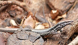
The Soutpansberg rock lizard is a small (40–50 mm) flattened species of lizard in the family Lacertidae. It has been described as a diurnal, rock-dwelling species inhabiting scree and rocky outcrops at altitudes from 900 to 1600 m. It is endemic to the Limpopo Province in the north of South Africa.

Mapungubwe National Park is a national park in the Limpopo Province, South Africa. The park protects the historical site of Mapungubwe Hill, which was the capital of the Kingdom of Mapungubwe, as well as the wildlife and riverine forests along the Limpopo River. The Mapungubwe Hill was the site of a community dating back to the Iron Age. Evidence has shown that it was a prosperous community. Archaeologists also uncovered the famous Golden Rhinoceros of Mapungubwe figurine from the site.

Blouberg Nature Reserve is a protected area situated close to Vivo, west of Louis Trichardt in the Limpopo Province, of South Africa. It covers an area of 9,360 hectares from the eastern portion of the Blouberg mountain range to the savanna near the Brak River, and is founded by Peter Dix but was sold and now managed and administered by the Limpopo Provincial Government.
Langjan Nature Reserve, is situated in Limpopo province, South Africa, on the R521 to Alldays, west of Makhado, close to the Blouberg Nature Reserve
Soutpansberg Conservancy, also known as Western Soutpansberg Conservancy, is a protected area situated in the northern part of the Limpopo province of South Africa. The reserve has an area of about 90,000 Ha and consists mostly in the mountainous terrain of the western part of the Soutpansberg Range. The Brak River, a tributary of the Sand River, flows beyond the western end of the Soutpansberg Conservancy. The Waterpoort, the deep gorge cut by the Sand River across the range is located in the central part of the protected area.

Kogelberg Nature Reserve is a nature reserve of 3,000 ha comprising the Kogelberg Mountain Range, to the east of Cape Town, South Africa.

Nwanedi Provincial Park, is a protected area in the northern part of the Limpopo province of South Africa. It is located about 20 km east of Tshipise and 35 km north of Thohoyandou, to the west of Kruger National Park. The Nwanedi park has an area of about 11,170 ha and includes a part of the wooded foothills of the Soutpansberg Range. The twin dams, the Nwanedi Dam and the Luphephe Dam, at the confluence of the Nwanedi River and its main tributary, the Luphephe River, are located in the protected area. One of the secrets of the Game Reserve is their spectacular waterfall, known as Tshihovhohovho Falls. The park is well stocked with game, including a fair number of white rhino in its lowveld zone.

The Soutpansberg Military Area (SMA) Headquarters was situated in Messina in the Northern Province of South Africa. The size of the area for which the SMA was responsible for was approximately 4,040 square kilometres (1,560 sq mi).
Mapesu Private Game Reserve is a game reserve in Limpopo Province, South Africa. The reserve adjoins the Mapungubwe National Park and World Heritage Site, with which it shares a 12.5 km Northern border. The main entrance gate to the reserve is located approximately 7 km east of Mapungubwe's entrance gate. It was established in 2014 and covers an area of over 7,200 hectares. The reserve protects various bird, mammal and tree species and is slated to become part of the Greater Mapungubwe Transfrontier Conservation Area in phase 2 as part of the proposed Limpopo Valley Game Reserve.
Tomomingi szutsi is a species of jumping spider in the genus Tomomingi that was first described in 2013. It is related to the similar Tomomingi holmi, but lives in the grasslands of the Soutpansberg mountain range in South Africa. The spider is small, brown and hairy.


