Blue Springs, Alabama

Last updated

Blue Springs, Alabama
Blue Springs Alabama.JPG
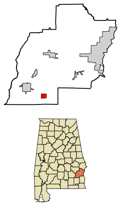
Barbour County Alabama Incorporated and Unincorporated areas Blue Springs Highlighted 0107672.svg
Location of Blue Springs in Barbour County, Alabama.
Coordinates: 31°39′51″N85°29′45″W / 31.66417°N 85.49583°W / 31.66417; -85.49583
Country United States
State Alabama
County Barbour
Area
[1]
  Total2.90 sq mi (7.50 km2)
  Land2.90 sq mi (7.50 km2)
  Water0.00 sq mi (0.00 km2)
Elevation
305 ft (93 m)
Population
 (2020)
  Total84
  Density29.01/sq mi (11.20/km2)
Time zone UTC-6 (Central (CST))
  Summer (DST) UTC-5 (CDT)
ZIP code
36017
Area code 334
FIPS code 01-07672
GNIS feature ID0154990

Blue Springs is a town in Barbour County, Alabama, United States. At the 2020 census, the population was 84. The town is the home of Blue Springs State Park.

Contents

Geography

Blue Springs is located at 31°39'51.588" North, 85°29'45.308" West (31.664330, -85.495919). [2]

According to the U.S. Census Bureau, the town has a total area of 2.9 square miles (7.5 km2), all land.

Demographics

Historical population
CensusPop.Note
1910 117
1920 16238.5%
1930 1641.2%
1940 1671.8%
1950 111−33.5%
1960 94−15.3%
1970 13745.7%
1980 112−18.2%
1990 108−3.6%
2000 12112.0%
2010 96−20.7%
2020 84−12.5%
U.S. Decennial Census [3]

As of the census [4] of 2000, there were 121 people, 49 households, and 36 families residing in the town. The population density was 41.8 inhabitants per square mile (16.1/km2). There were 54 housing units at an average density of 18.7 per square mile (7.2/km2). The racial makeup of the town was 99.17% White and 0.83% Black or African American.

There were 49 households, out of which 28.6% had children under the age of 18 living with them, 67.3% were married couples living together, 6.1% had a female householder with no husband present, and 24.5% were non-families. 20.4% of all households were made up of individuals, and 10.2% had someone living alone who was 65 years of age or older. The average household size was 2.47 and the average family size was 2.84.

In the town, the population was spread out, with 22.3% under the age of 18, 7.4% from 18 to 24, 28.1% from 25 to 44, 31.4% from 45 to 64, and 10.7% who were 65 years of age or older. The median age was 39 years. For every 100 females, there were 95.2 males. For every 100 females age 18 and over, there were 95.8 males.

The median income for a household in the town was $38,000, and the median income for a family was $38,250. Males had a median income of $27,000 versus $21,500 for females. The per capita income for the town was $17,224. There were 6.5% of families and 4.3% of the population living below the poverty line, including no under eighteens and 33.3% of those over 64.

Points of interest

Related Research Articles

<span class="mw-page-title-main">Tallapoosa County, Alabama</span> County in Alabama, United States

Tallapoosa County is located in the east-central portion of the U.S. state of Alabama. As of the 2020 census, the population was 41,311. Its county seat is Dadeville. Its largest city is Alexander City.

<span class="mw-page-title-main">Clio, Alabama</span> City in Alabama, United States

Clio is a city in Barbour County, Alabama, United States. The population was 1,399 at the 2010 census, down from 2,206 in 2000, at which time it was a town. It is the birthplace of former Alabama governor George C. Wallace, as well as Baseball Hall of Famer and former Atlanta Braves broadcaster Don Sutton.

<span class="mw-page-title-main">Glencoe, Alabama</span> City in the United States

Glencoe is a city in Calhoun and Etowah counties in the U.S. state of Alabama. It is part of the Gadsden Metropolitan Statistical Area. The city incorporated in 1939. The population was 5,160 at the 2010 census.

<span class="mw-page-title-main">Level Plains, Alabama</span> City in Alabama, United States

Level Plains is a small town in Dale County, Alabama, United States. At the 2020 census, the population was 1,825. It is part of the Ozark micropolitan statistical area. Level Plains was ranked as a city from 2010 to 2020, but due to a population decline reverted to a town after the 2020 Census.

<span class="mw-page-title-main">Coffee Springs, Alabama</span> Town in Alabama, United States

Coffee Springs is a town in Geneva County, Alabama, United States. It was incorporated in 1900, and it is considered to be a part of the Dothan, Alabama Metropolitan Statistical Area. At the 2010 census the population was 228, down from 251.

<span class="mw-page-title-main">Taylor, Alabama</span> Town in Alabama, United States

Taylor is a town in Geneva and Houston counties in the U.S. state of Alabama. Taylor was first settled in the 1870s, named after an early family that helped secure the first post office. It was not incorporated until almost a century later in June 1967. It is part of the Dothan, Alabama Metropolitan Statistical Area. At the 2010 census the population was 2,375, up from 1,898 in 2000.

<span class="mw-page-title-main">Cowarts, Alabama</span> Town in Alabama, United States

Cowarts is a town in Houston County, Alabama, United States. The town incorporated in August 1961. It is part of the Dothan, Alabama Metropolitan Statistical Area. At the 2010 census the population was 1,871, up from 1,546 in 2000.

<span class="mw-page-title-main">Sylvan Springs, Alabama</span> Town in Alabama, United States

Sylvan Springs is a town in Jefferson County, Alabama, United States, located northwest of the Birmingham suburb of Pleasant Grove. It incorporated on May 22, 1957. At the 2010 census the population was 1,542, up from 1,465 in 2000. This area was damaged by an F5 tornado on April 8, 1998, including the First United Methodist Church of Sylvan Springs.

<span class="mw-page-title-main">Spring Grove, Indiana</span> Town in Indiana, United States

Spring Grove is a town in Wayne Township, Wayne County, in the U.S. state of Indiana. The population was 344 at the 2010 census.

<span class="mw-page-title-main">Mardela Springs, Maryland</span> Town in Maryland, United States

Mardela Springs is a town in Wicomico County, Maryland, United States. The population was 357 at the 2010 census. It is included in the Salisbury, Maryland-Delaware Metropolitan Statistical Area.

<span class="mw-page-title-main">Wheatland, Pennsylvania</span> Former borough in Pennsylvania, United States

Wheatland was a former borough in Mercer County, Pennsylvania, United States, along the Shenango River. The population was 583 at the 2020 census. On January 1, 2024, Wheatland merged with the neighboring city of Hermitage after residents of both communities voted to approve the merger in November 2022.

<span class="mw-page-title-main">Springfield, South Carolina</span> Town in South Carolina, United States

Springfield is a town in Orangeburg County, South Carolina, United States. The population was 524 at the 2010 census.

<span class="mw-page-title-main">Cairo, West Virginia</span> Town in West Virginia, United States

Cairo is a town in Ritchie County, West Virginia, United States, along West Virginia Route 31, the North Fork of the Hughes River, and the North Bend Rail Trail. The population was 174 at the 2020 census.

<span class="mw-page-title-main">Reedy, West Virginia</span> Town in West Virginia, United States

Reedy is a town in Roane County, West Virginia, United States. The population was 152 at the 2020 census.

<span class="mw-page-title-main">Camden-on-Gauley, West Virginia</span> Town in West Virginia, United States

Camden-on-Gauley is a town in Webster County, West Virginia, United States, along the Gauley River. The population was 126 at the 2020 census.

<span class="mw-page-title-main">North Hills, West Virginia</span> Town in West Virginia, United States

North Hills is a town in Wood County, West Virginia, United States. It is a suburb of Parkersburg. The population was 837 at the 2020 census. North Hills was incorporated on February 15, 1979.

<span class="mw-page-title-main">Tainter, Wisconsin</span> Town in Wisconsin, United States

The Town of Tainter is a town in Dunn County, Wisconsin, United States. The population was 2,116 at the 2000 census. Part of the census-designated place of Tainter Lake is located in the town. The unincorporated community of Norton is also located in the town.

<span class="mw-page-title-main">Cassel, Wisconsin</span> Town in Wisconsin, United States

Cassel is a town in Marathon County, Wisconsin, United States. It is part of the Wausau, Wisconsin Metropolitan Statistical Area. The population was 911 at the 2010 census.

<span class="mw-page-title-main">Spring Hill, Indiana</span> Town in Indiana, United States

Spring Hill is a town in Marion County, Indiana, United States. The population was 95 at the 2020 census. It has existed as an "included town" since 1970, when it was incorporated into Indianapolis as part of Unigov. It is part of Indianapolis, but retains town governmental powers under IC 36-3-1-11.

<span class="mw-page-title-main">Blue Mounds (town), Wisconsin</span> Town in Wisconsin, United States

Blue Mounds is a town in Dane County, Wisconsin, United States. The population was 899 at the 2020 census. The Village of Blue Mounds is located within the town.

References

  1. "2020 U.S. Gazetteer Files". United States Census Bureau. Retrieved October 29, 2021.
  2. "US Gazetteer files: 2010, 2000, and 1990". United States Census Bureau. February 12, 2011. Retrieved April 23, 2011.
  3. "U.S. Decennial Census". Census.gov. Retrieved June 6, 2013.
  4. "U.S. Census website". United States Census Bureau . Retrieved January 31, 2008.

31°39′52″N85°29′45″W / 31.66433°N 85.495919°W / 31.66433; -85.495919