Bluff Dale, Texas | |
|---|---|
Unincorporated community Census designated place | |
 | |
 Bluff Dale | |
| Coordinates: 32°20′59″N98°01′18″W / 32.34972°N 98.02167°W | |
| Country | United States |
| State | Texas |
| County | Erath |
| Elevation | 912 ft (278 m) |
| Population (2020) | |
• Total | 151 |
| Time zone | UTC−06:00 (CST) |
| • Summer (DST) | UTC−05:00 (CDT) |
| Area code | 254 |
| GNIS feature ID | 2805774 [1] |
Bluff Dale is an unincorporated community and census designated place (CDP) in Erath County, Texas, United States.
Contents
- Demographics
- 2020 Census
- Housing
- Cost of living
- Education
- Historical markers
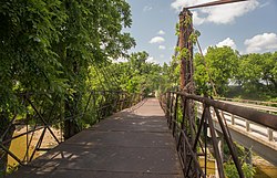
- Bluff Dale Suspension Bridge
- Bluff Dale Tabernacle
- Old Public Water Well TX3786
- Photo gallery
- Climate
- References
The Bluff Dale Independent School District serves area students.
Bluff Dale, Texas is on U.S. Highway 377 and the North Paluxy River in northeastern Erath County. It was originally called Bluff Springs by pioneers who settled nearby; Bluff Dale became the town name when the post office was established in 1877. In 1889, when the Fort Worth and Rio Grande Railway was built, Jack Glenn donated land for the development of a town. The town was incorporated in 1908. By 1915, a bank and newspaper had been developed. In 1936, Bluff Dale had 680 residents, 500 in 1940, 123 in 1980, and 300 in 1989. In 1989, the town had a Garden Club, three churches, a volunteer fire department, five historical markers, and a beautification committee. A gas station–convenience store was built circa 2002. Around 2005, a bank was opened up. [2]