
Newbury is a market town in the county of Berkshire, England, and is home to the administrative headquarters of West Berkshire Council. The town centre around its large market square retains a rare medieval Cloth Hall, an adjoining half timbered granary, and the 15th-century St Nicolas Church, along with 17th- and 18th-century listed buildings. As well as being home to Newbury Racecourse, it is the headquarters of Vodafone and software company Micro Focus International. In the valley of the River Kennet, 26 mi (42 km) south of Oxford, 25 mi (40 km) north of Winchester, 27 mi (43 km) southeast of Swindon and 20 mi (32 km) west of Reading.

Speen is a village and civil parish in West Berkshire, England. Centred 2 miles (3 km) north west of the largest town in the district, Newbury, Speen has clustered settlements, the largest of which is Speen village, which is contiguous with Newbury, and the others, buffered from the town by the A34 road, are Bagnor, Stockcross, Woodspeen and Marsh Benham. Its other land is an approximately even mixture of woodland and agricultural fields including hay meadows for livestock feed and pasture. The area varies greatly in elevation, having the Reading to Taunton Line alongside the north bank of the River Kennet as its southern boundary and both banks of the River Lambourn in its north with elevated ground in between. Benham Park in the south-west of the area is a listed landscape garden and house.

Hungerford is a historic market town and civil parish in Berkshire, England, 8 miles (13 km) west of Newbury, 9 miles (14 km) east of Marlborough, 27 miles (43 km) northeast of Salisbury and 60 miles west of London. The Kennet and Avon Canal passes through the town alongside the River Dun, a major tributary of the River Kennet. The confluence with the Kennet is to the north of the centre whence canal and river both continue east. Amenities include schools, shops, cafés, restaurants, and facilities for the main national sports. Hungerford railway station is a minor stop on the Reading to Taunton Line.

The River Lambourn is a chalk stream in the English county of Berkshire. It rises in the Berkshire Downs near its namesake village of Lambourn and is a tributary of the River Kennet, which is itself a tributary of the River Thames.

Sonning is a village and civil parish in Berkshire, England, on the River Thames, east of Reading. The village was described by Jerome K. Jerome in his book Three Men in a Boat as "the most fairy-like little nook on the whole river".

Aldermaston is a village and civil parish in Berkshire, England. In the 2011 census, the parish had a population of 1,015. The village is in the Kennet Valley and bounds Hampshire to the south. It is approximately 8 miles (13 km) from Newbury, Basingstoke, and Reading and is 46 miles (74 km) from London.

Lambourn is a village and civil parish in Berkshire, England. It lies just north of the M4 Motorway between Swindon and Newbury, and borders Wiltshire to the west and Oxfordshire to the north. After Newmarket it is the largest centre of racehorse training in England, and is home to a rehabilitation centre for injured jockeys, an equine hospital, and several leading jockeys and trainers. To the north of the village are the prehistoric Seven Barrows and the nearby long barrow. In 2004 the Crow Down Hoard was found close to the village.

Bradfield is a village and civil parish in Berkshire, England. Aside from farms and a smaller amount of woodland its main settlements are Bradfield Southend, its medieval-founded nucleus and the hamlet of Tutts Clump. Bradfield village is the home of the public school Bradfield College.
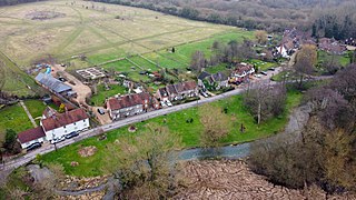
Bagnor is a village close to the town of Newbury in the English county of Berkshire and situated on the banks of the River Lambourn. At the 2011 census the population was included in the civil parish of Speen. It is best known as the home of the Watermill Theatre.

Ufton Nervet is a village and civil parish in West Berkshire, England centred 6 miles (10 km) west southwest of the large town of Reading and 7 miles east of Thatcham. Ufton Nervet has an elected civil parish council.

Frilsham is a village and civil parish 4 miles (6.4 km) from Newbury, in the English county of Berkshire.

Leckhampstead is a village and civil parish in West Berkshire, England in the North Wessex Downs. A road and boundary stone in Leckhampstead, the Hangman's Stone and Hangman's Stone Lane, are named after a tale of a man who roped and carried a stolen sheep from a farm in Leckhampstead around his neck, but which strangled him after he stopped and slept. After a long hiatus the area returned to full village status in 1864. Its hamlet of Hill Green has six listed buildings and the amenities of the village include a public house, church and village hall. The associated hamlet of Leckhampstead Thicket has a high proportion of its buildings that are thatched cottages and has a Primitive Methodist chapel, dated 1874.

Boxford is a village and civil parish in the unitary authority of West Berkshire, England. The village is on the east bank of the River Lambourn, about 4 miles (6.4 km) northwest of Newbury but south of the M4 motorway. The hamlet of Westbrook is on the opposite bank of the Berkshire Downs tributary.

Fawley is a village and civil parish in West Berkshire, England. The hub of the village is centred 3.5 miles (5.6 km) east of Lambourn and has a sub-community within its bounds, Little or South Fawley. It includes the depopulated small hill settlement of Whatcombe. Fawley is the inspiration for "Marygreen" in Thomas Hardy's Jude the Obscure.

Arrow is a village in the Stratford-on-Avon district of Warwickshire, England. Together with the entirely rural hamlet of Weethley, it forms since 1 April 2004 the civil parish of Arrow with Weethley. The parish lies midway between Redditch and Evesham. From Alcester the River Arrow flows southwards to the river Avon, and to the west of the river the present road to Evesham joins that to Worcester at a busy junction where, near the Old Toll House, stands the hamlet of Arrow, a group of modernized black and white farm workers' cottages which have risen up the social scale to become homes for business people. Arrow with Weethley parish falls under the local government district and parliamentary constituency of Stratford-on-Avon, and the Church of England Diocese of Coventry. In 2001 the parish had a population of 208.

Damerham is a rural village and civil parish in the New Forest district of Hampshire, England, near Fordingbridge. The area has notable Neolithic and Bronze Age barrows. It was the site of an Anglo-Saxon religious community, mentioned in the will of Alfred the Great. By the time of Domesday Book (1086), Damerham was a major settlement in the possession of Glastonbury Abbey. The village has a riverside mill and a Norman church.

Teynham is a large village and civil parish in the borough of Swale in Kent, England. The parish lies between the towns of Sittingbourne and Faversham, immediately north of the A2 road, and includes the hamlet of Conyer on an inlet of the Swale, the channel that separates mainland Kent from the Isle of Sheppey. Other hamlets include Deerton Street, Frognal, and Teynham Street. Teynham also has a carnival court. There is selections every year when girls from 14-18 can audition to be Miss Teynham or a Teynham princess.

Denchworth is a village and civil parish about 2.5 miles (4 km) north of Wantage. It was part of Berkshire until the 1974 boundary changes transferred the Vale of White Horse to Oxfordshire. The 2011 Census recorded the parish's population as 171. The parish is bounded by the Land Brook in the west and the Childrey Brook in the east. The Great Western Main Line between Reading and Swindon runs through the parish just south of the village, but there is no station.

Seacourt is a deserted medieval village near the City of Oxford. The site is now mostly beneath the Oxford Western By-pass, about 0.3 miles (0.48 km) south of the Seacourt / Hinksey Stream crossing.
Chacombe is a village and civil parish in West Northamptonshire, England, about 3 miles (5 km) north-east of Banbury. It is bounded to the west by the River Cherwell, to the north by a tributary and to the south-east by the Banbury–Syresham road. The 2011 Census gave a parish population of 659 and a 2019 estimate 693.


