
The history of the Falkland Islands goes back at least five hundred years, with active exploration and colonisation only taking place in the 18th century. Nonetheless, the Falkland Islands have been a matter of controversy, as they have been claimed by the French, British, Spaniards and Argentines at various points.

The Falkland Islands are located in the South Atlantic Ocean between 51°S and 53°S on a projection of the Patagonian Shelf, part of the South American continental shelf. In ancient geological time this shelf was part of Gondwana, and around 400 million years ago split from what is now Africa and drifted westwards from it. Today the islands are subjected to the Roaring Forties, winds that shape both their geography and climate.

East Falkland is the largest island of the Falklands in the South Atlantic, having an area of 6,605 km2 or 54% of the total area of the Falklands. The island consists of two main land masses, of which the more southerly is known as Lafonia; it is joined by a narrow isthmus where the settlement of Goose Green is located, and it was the scene of the Battle of Goose Green during the Falklands War.

The ruddy-headed goose is a large sheldgoose, which breeds in southernmost South America.
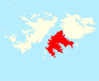
Lafonia is a peninsula forming the southern part of East Falkland, the largest of the Falkland Islands.

Darwin is a settlement in Lafonia on East Falkland, Falkland Islands, lying on Choiseul Sound, on the east side of the island's central isthmus, 2.5 miles (4.0 km) north of Goose Green. It was known occasionally as Port Darwin.

Goose Green is a settlement in Lafonia on East Falkland in the Falkland Islands. It lies on Choiseul Sound, on the east side of the island's central isthmus, 2 miles (3.2 km) south-southwest of Darwin. With a population of about 40, it is the third-largest settlement of the Falkland Islands, after Stanley and Mount Pleasant.

The Camp is the term used in the Falkland Islands to refer to any part of the islands outside the islands' only significant town, Stanley, and often the large RAF base at Mount Pleasant. It is derived from the Spanish word campo, for "countryside".
The culture of the Falkland Islands is essentially analogous to that of British culture. The Falkland Islands have a large non-native born population, mainly white and from England, but also from Saint Helena.

The Falkland Islands Company Ltd is a diversified goods and services company owned by FIH Group. Known locally as FIC, it was founded in 1851 and was granted a royal charter to trade in 1852 by Queen Victoria. It was originally founded by Samuel Fisher Lafone to exploit wild cattle in East Falkland, but they gave way to sheep farming and then to a range of trading activities in the Falkland Islands ranging from retail shops and cafés to insurance and vehicle hire.
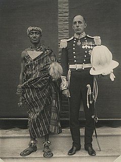
Sir Arnold Wienholt Hodson was a British colonial administrator who was Governor in turn of the Falkland Islands, Sierra Leone and the Gold Coast.
North Arm is a settlement in Lafonia, the southern part of East Falkland, in the Falkland Islands, It is on the south coast, on the shore of the Bay of Harbours, and overlooks Sea Lion Island in the distance. In 2007, the population was 25 people, six of them children. It is the largest settlement on East Falkland south of Goose Green. North Arm is 90 miles (140 km) from Stanley, and it takes four and a half hours to drive there.
Walker Creek is a settlement on East Falkland, in the Falkland Islands, in Lafonia. It is on the shore of the Choiseul Sound, and overlooks Sea Lion Island in the distance. It is the second largest settlement on East Falkland south of Goose Green, after North Arm.
David Rowell & Co. was a company based in Westminster, London that fabricated wrought iron and wire rope, built suspension footbridges, and structural steel frame buildings. They were established in 1855 and closed in 1970.

Duplicate: List of Falkland Islands-related topics

The Arapuni Suspension Bridge is located just downstream from the Arapuni Power Station on the Waikato River in the South Waikato District of New Zealand. The 152-metre (499 ft) suspension bridge in the bush-lined gorge was built in the mid-1920s to allow workers from the village of Arapuni to access the power station construction site.
Orqueta Creek is a stream in the center of the East Falkland in the Falkland Islands, more precisely north of Lafonia and south of Goose Green, which flows eastward and flows into Bodie Creek. Throughout its stream, it crosses the settlement of Orqueta. The toponym of Horqueta in Falkland Islands English goes back to the gauchos Rioplantenses who inhabited the area towards mid of 19th century and refers to the Paspalum notatum.
Bodie Creek, also called Bodie Inlet, is the estuary of Orqueta Creek and other small streams into Choiseul Sound, located south of the settlement of Goose Green in Lafonia, in the centre of East Falkland, Falkland Islands.
