
Richmondtown is a neighborhood in the Mid-Island section of Staten Island, New York City. It is bounded by Arthur Kill Road on the northwest, Richmond Road on the north, Amboy Road on the east and southeast, and the United Hebrew and Ocean View cemeteries on the southwest.

Richmond Creek is a major stream in Staten Island, New York City. Its upper drainage basin includes the remote forested hills in the center of the island. It empties into the Fresh Kills.
Prince's Bay is the name of a neighborhood located on the South Shore of New York City's borough of Staten Island. Prince's Bay is bordered to the north by Huguenot, to the south by the Raritan Bay, and to the west by Pleasant Plains. The neighborhood is represented in the New York State Senate by Andrew Lanza, in the New York State Assembly by Michael Reilly, and in the New York City Council by Joe Borelli.

Historic Richmond Town is an authentic town and farm museum complex in the neighborhood of Richmondtown, Staten Island, in New York City. It is located near the geographical center of the island, at the junction of Richmond Road and Arthur Kill Road. Staten Island Historical Society and Historic Richmond Town are two different names for the same organization, reflecting its long history and evolution.

The Moravian Cemetery is a cemetery in the New Dorp neighborhood of Staten Island, New York City. Located at 2205 Richmond Road, the Moravian is the largest and oldest active cemetery on Staten Island, having opened in 1740. The cemetery encompasses 113 acres and is the property of the local Moravian Church congregation of Staten Island. To the cemetery's southwest is High Rock Park, one of the constituent parks of the Staten Island Greenbelt.
Mid-Island is frequently applied to a series of neighborhoods within the New York City borough of Staten Island.
Lighthouse Hill is the name of a hill, and the neighborhood situated thereon, in the New York City borough of Staten Island. Lighthouse Hill is situated to the north of Richmondtown, south of Todt Hill, and west of Grant City.

The Abraham Manee House, also known as the Manee-Seguine Homestead, is a three-part Colonial Dutch dwelling on Staten Island in New York. It was designated a New York City landmark in 1984. Located on Purdy Place adjacent to Lemon Creek, on the South Shore of Staten Island, the oldest section is a one-room structure built by Paulus Regrenier in 1670, a French Huguenot fleeing religious persecution in Europe. The building is similar to the Billiou-Stillwell-Perine House in Old Town.

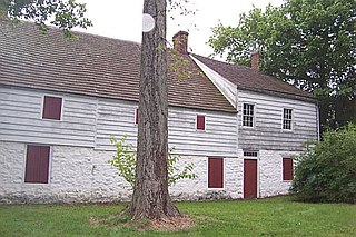
The Christopher House is a stone masonry farmhouse at Historic Richmond Town in Staten Island, New York City. It is associated with two of the oldest Staten Island families. It was also used as a meeting place during the American Revolution, while being the residence of Joseph Christopher, a member of the Richmond County Committee of Safety from 1775-1776. It was moved to Historic Richmond Town in late 1969 and restored for museum presentation from 1975-1977.

The Olmsted–Beil House was a large farm and modest Dutch farmhouse at 4515 Hylan Boulevard in the South Shore of Staten Island, New York City. The house was purchased by Frederick Law Olmsted's father and given to Olmsted in 1848 to grow crops, plant trees and clear for pasture for livestock. It is on one of the higher hills overlooking Raritan Bay, and Sandy Hook in New Jersey.

Lookout Place or Fort Hill was an American Revolutionary War British garrison, or earthen mound-fortress roughly 44 feet square at the top of La Tourette Hill in Historic Richmondtown, Staten Island, New York. The redoubt was constructed in 1776 by British Regulars during the occupation of Richmond County. General William Howe planned his successful capture of New York City while encamped on the Island, along with 30,000 British and Hessian soldiers joining to suppress the rebellion after the arrival of his brother Admiral Richard Howe. The fort overlooked a fresh water spring about 200 feet directly below, the Old Mill Road, Fresh Kills which is a tributary of Richmond Creek, St. Andrews Church and the town of Richmond, then referred to as Cuckoldstown, in the valley just below La Tourette Hill.

The Britton Cottage, formerly known as the Cubberly House, is a house in the Historic Richmond Town museum complex in the neighborhood of Richmondtown, Staten Island, in New York City. The oldest section of the cottage dates to 1671, with additions in the mid-18th century. It is constructed of stone and timberframe components. The house was originally located at the intersection of New Dorp Lane and Cedar Grove Avenue in the New Dorp Beach section of Staten Island, but was moved to its current location in 1967 when it was threatened with demolition.

The Stephens-Black House is a 19th-century house featured in Historic Richmond Town on Staten Island, New York City. It was designated as a New York City Landmark on August 26, 1969.
The Treasure House is a historic building located in Staten Island, New York City, New York, US. Samuel Grasset, a tanner and leather worker, built the original construction in approximately 1700. Additions were made in 1740, 1790 and 1860. Subsequent owners of the house in subsequent centuries include a cord wainer (shoemaker), innkeeper, stonemason, and coach trimmer. A number of local businesses have also occupied the structure. The house was named after a legend that a cache of American Revolutionary War era gold coins was discovered during renovation in about 1860.
The John Bennett House was built in 1839 with an addition built in 1854, was built as part of a real estate development near the Third County Courthouse in Historic Richmondtown, Staten Island, New York. This Greek Revival style residence was home to shipping merchant John Bennett and his family from c.1848-1917. The building later served as a restaurant. A seasonal cafe and restaurant is located in the cellar bakery and is accessible from Richmond Road.
The Third County Courthouse is an 1837 Greek Revival building at 302 Center Street in Historic Richmond Town, near the geographic center of Staten Island, New York. Preceded by two smaller courthouses, it was the Richmond County Courthouse during most of the nineteenth century and was in use until 1919, when it was replaced by the Richmond County Courthouse in St. George.
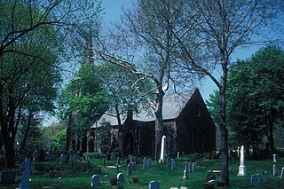
The Church of St. Andrew is a historic Episcopal church located at Arthur Kill and Old Mill Roads on the north side of Richmondtown in Staten Island, New York.

Arthur Kill Road is a major northeast-southwest artery along the South-West Shore of the New York City borough of Staten Island. It is 8.54 miles (13.74 km) long, and runs through the neighborhoods of Tottenville, Richmond Valley, Charleston, Rossville, Woodrow, Huguenot, Arden Heights, Annadale, Eltingville, Greenridge, Great Kills, and Richmondtown.

The Church of St. Patrick is a parish church under the authority of the Roman Catholic Archdiocese of New York, located in Richmondtown, Staten Island, New York City.
Richmond Engine Co. 1 is volunteer fire department located in the Richmondtown neighborhood of Staten Island, New York City, New York that works in cooperation with the New York City Fire Department.
