Krakoma is a village in the Bamingui-Bangoran Prefecture in the northern Central African Republic.
Pata, also known as Kpata, is a village in the Bamingui-Bangoran prefecture in the northern Central African Republic.

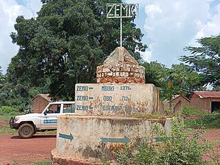
Zemio is a town and sub-prefecture in the Haut-Mbomou prefecture of the south-eastern Central African Republic. Zemio was the former capital of the Sultanate of Zemio before it was abolished in 1923 by France.
Derbissaka, also spelled Derbisaka, is a village located in Mbomou, Central African Republic.
Dembia is a village located near the border of Mbomou and Haut-Mbomou Prefecture.
Agoumar is a village located in Mbomou. It is situated near Rafai town in Central African Republic.
Guinikoumba, also spelled Guénékoumba, is a village located in Haut-Mbomou Prefecture, Central African Republic.
Tabane is a village located in Haut-Mbomou Prefecture, Central African Republic.
Tambourah, also spelled Tamboura, is a village located in Haut-Mbomou Prefecture, Central African Republic.
Bétoko is a village located in Lim-Pendé Prefecture, Central African Republic. Until December 2020, Bétoko was part of Ouham-Pende.
Bahr, also spelled Barh, is a village located in Haut-Mbomou Prefecture, Central African Republic.
Sélim is a village situated in Mbomou Prefecture, Central African Republic.
Bodjomo, also spelled Bojomo, is a village located in Ouham Prefecture, Central African Republic.
Pougol is a town situated in Lim-Pendé, Central African Republic. Until 2020, the town was part of Ouham-Pendé.
Aliwali is a village located 12 km from Zemio in Haut-Mbomou Prefecture, Central African Republic.
Digui is a village located in Ouaka Prefecture, Central African Republic. The village is strategic since it is situated at the crossroads to Bambari, Alindao, and Ngakobo.
Batobadja is a village situated in Ouaka Prefecture, Central African Republic.
Lioto, also spelled Liotto or Lihoto, is a village situated in Ouaka Prefecture, Central African Republic.
Kongbo is a village situated in Basse-Kotto Prefecture, Central African Republic.
Guibéré is a village situated in Haut-Mbomou Prefecture, Central African Republic.

