Boitzenburger Land

Last updated
Boitzenburger Land
RK 0908 3807 Schloss Boitzenburg.jpg
Boitzenburg Castle
Wappen Boitzenburger Land.png
Location of Boitzenburger Land within Uckermark district
Boitzenburger Land in UM.pngMittenwaldePinnowSchenkenbergSchönfeld
Germany adm location map.svg
Red pog.svg
Boitzenburger Land
Brandenburg location map.svg
Red pog.svg
Boitzenburger Land
Coordinates: 53°16′N13°36′E / 53.267°N 13.600°E / 53.267; 13.600 Coordinates: 53°16′N13°36′E / 53.267°N 13.600°E / 53.267; 13.600
Country Germany
State Brandenburg
District Uckermark
Government
   Mayor (201624) Frank Zimmermann [1]
Area
  Total215.90 km2 (83.36 sq mi)
Elevation
80 m (260 ft)
Population
 (2021-12-31) [2]
  Total3,110
  Density14/km2 (37/sq mi)
Time zone UTC+01:00 (CET)
  Summer (DST) UTC+02:00 (CEST)
Postal codes
17268
Dialling codes 039884, 039885, 039889
Vehicle registration UM
Website gemeinde-boitzenburger-land.de

Boitzenburger Land is a municipality in the Uckermark district, in Brandenburg, Germany.

Contents

Geography

The municipality, with an area of 215.9 square kilometres (83.4 sq mi) one of largest in Germany, is located in the northeastern part of Brandenburg, close to the border with the state of Mecklenburg-Vorpommern. The rural community is part of the Uckermark historic region, it is surrounded by extended forests and the Uckermark Lakes Nature Park. In the south, it borders the towns of Templin and Lychen.

History

A settlement named Bozineburc was first mentioned in a 1215 deed. After the whole Uckermark region had passed to the Margraves of Brandenburg according to the 1250 Treaty of Landin, a Cistercian monastery at the site was founded; documented since 1271, about the time when nearby Chorin Abbey was established. In 1536 the abbey was secularised during the Protestant Reformation and devastated by Danish troops in the Thirty Years' War one hundred years later.

Boitzenburg Castle was first mentioned in 1276, it was occupied by Margrave William I of Meissen in 1398 but returned to Brandenburg in 1415. From 1429 the estates were held by the Arnim noble family. Damaged in the Thirty Years' War, when it was a possession of Field Marshal Hans Georg von Arnim-Boitzenburg, the fortress was rebuilt by his descendants in a Baroque style from 1740 onwards. Refurbished according to plans designed by Friedrich August Stüler between 1838 and 1842, it received its present Neo-Renaissance appearance in 1881–1884. The adjacent landscape garden was laid out by Peter Joseph Lenné around 1840. Boitzenburg was then held by Adolf Heinrich von Arnim-Boitzenburg, who became the first Minister President of Prussia in 1848.

After World War II, the Arnim family was disseized and the castle was used as recreation home of the East German National People's Army. Today it houses a hotel. The present-day municipality was established by the merger of ten villages in 1992.

Demography

Boitzenburger Land: Population development
within the current boundaries (2020) [3]
YearPop.±% p.a.
1875 5,797    
1890 5,687−0.13%
1910 5,234−0.41%
1925 5,504+0.34%
1939 5,019−0.66%
1950 7,443+3.65%
1964 5,677−1.92%
YearPop.±% p.a.
1971 5,365−0.80%
1981 4,918−0.87%
1985 5,068+0.75%
1990 5,251+0.71%
1995 4,997−0.99%
2000 4,631−1.51%
2005 4,119−2.32%
YearPop.±% p.a.
2010 3,668−2.29%
2015 3,213−2.61%
2016 3,169−1.37%
2017 3,151−0.57%
2018 3,102−1.56%
2019 3,089−0.42%
2020 3,112+0.74%

People from Boitzenburger Land

Related Research Articles

Prignitz is a Kreis (district) in the northwestern part of Brandenburg, Germany. Neighboring are the district Ludwigslust-Parchim in Mecklenburg-Western Pomerania, the district Ostprignitz-Ruppin in Brandenburg, the district Stendal in Saxony-Anhalt and the district Lüchow-Dannenberg in Lower Saxony.

<span class="mw-page-title-main">Prenzlau</span> Town in Brandenburg, Germany

Prenzlau is a town in Brandenburg, Germany, the administrative seat of Uckermark District. It is also the centre of the historic Uckermark region.

<span class="mw-page-title-main">Schwedt</span> Town in Brandenburg, Germany

Schwedt is a town in Brandenburg, in northeastern Germany. With the official status of a Große kreisangehörige Stadt, it is the largest town of the Uckermark district, located near the river Oder, which forms the border with Poland.

<span class="mw-page-title-main">Angermünde</span> Town in Brandenburg, Germany

Angermünde is a town in the district of Uckermark in the state of Brandenburg, Germany. It is about 43 miles (69 km) northeast of Berlin, the capital of Germany.

<span class="mw-page-title-main">Doberlug-Kirchhain</span> Town in Brandenburg, Germany

Doberlug-Kirchhain is a German town in the district of Elbe-Elster, Lower Lusatia, Brandenburg.

<span class="mw-page-title-main">Nauen</span> Town in Brandenburg, Germany

Nauen is a small town in the Havelland district, in Brandenburg, Germany. It is chiefly known for Nauen Transmitter Station, the world's oldest preserved radio transmitting installation.

<span class="mw-page-title-main">Templin</span> Town in Brandenburg, Germany

Templin is a small town in the Uckermark district of Brandenburg, Germany. Though it has a population of only 17,127 (2006), in terms of area it is, with 377.01 km2, the second largest town in Brandenburg and the seventh largest town in Germany. The town is located in the south of the rural Uckermark region and its capital Prenzlau, north of the Schorfheide-Chorin Biosphere Reserve. The municipality comprises the villages of Ahrensdorf, Bebersee, Beutel, Densow, Gandenitz, Gollin, Gross Dölln, Gross Väter, Grunewald, Hammelspring, Herzfelde, Hindenburg, Klosterwalde, Petznick, Röddelin, Storkow and Vietmannsdorf.

<span class="mw-page-title-main">Hans Georg von Arnim-Boitzenburg</span> German general (1583–1641)

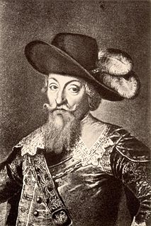
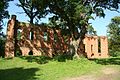
Johann or Hans Georg von Arnim-Boitzenburg was a German Field Marshal. At different times during the Thirty Years' War, he was a Field Marshal for the Holy Roman Empire and its opponent the Electorate of Saxony. He also pursued various diplomatic tasks.

<span class="mw-page-title-main">Fehrbellin</span> Municipality in Brandenburg, Germany

Fehrbellin is a municipality in Germany, located 60 km NW of Berlin. It had 9,310 inhabitants as of 2005, but has since declined to 8,606 inhabitants in 2012.

<span class="mw-page-title-main">Kloster Lehnin</span> Municipality in Brandenburg, Germany

Kloster Lehnin, or just Lehnin, is a municipality in the German state of Brandenburg. It lies about 24 km (15 mi) west-south-west of Potsdam.

<span class="mw-page-title-main">Zehdenick</span> Town in Brandenburg, Germany

Zehdenick is a town in the Oberhavel district, in Brandenburg, Germany. It is situated on the river Havel, 26 kilometres southeast of Fürstenberg/Havel, and 51 kilometres north of Berlin (centre). Since 31 July 2013, the city has the additional appellation "Havelstadt".

<span class="mw-page-title-main">Ahrensfelde</span> Municipality in Brandenburg, Germany

Ahrensfelde is a municipality in the district of Barnim, in Brandenburg, Germany. It is situated on the Barnim Plateau at the city limits of Berlin, about 13 km (8.1 mi) northeast of the city centre. The municipal area comprises the villages of Ahrensfelde, Blumberg, Eiche, Lindenberg, and Mehrow.

<span class="mw-page-title-main">Baruth/Mark</span> Town in Brandenburg, Germany

Baruth/Mark is a town in the Teltow-Fläming district of Brandenburg, Germany. It is situated 24 km east of Luckenwalde, and 53 km south of Berlin.

<span class="mw-page-title-main">Löwenberger Land</span> Municipality in Brandenburg, Germany

Löwenberger Land is a municipality in the Oberhavel district, in the German state of Brandenburg, about 50 km north of Berlin.

<span class="mw-page-title-main">Steinhöfel</span> Municipality in Brandenburg, Germany

Steinhöfel is a municipality in the Oder-Spree district, in Brandenburg, Germany. Since the beginning of 2019 it belongs to the collective municipality "Amt Odervorland"

<span class="mw-page-title-main">Heiligengrabe</span> Municipality in Brandenburg, Germany

Heiligengrabe is a municipality in the Ostprignitz-Ruppin district, in Brandenburg, Germany.

<span class="mw-page-title-main">Nordwestuckermark</span> Municipality in Brandenburg, Germany

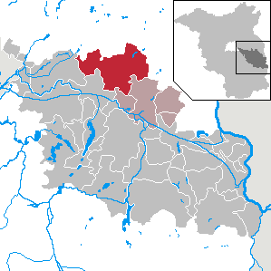
Nordwestuckermark is a municipality in the Uckermark district, in Brandenburg, Germany.

<span class="mw-page-title-main">Uckerland</span> Municipality in Brandenburg, Germany

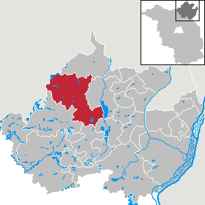
Uckerland is a municipality in the Uckermark district, in Brandenburg, Germany.

Amt Gartz (Oder) is an Amt in the district of Uckermark, in Brandenburg, Germany. Its seat is in Gartz.

Amt Oder-Welse is a former Amt in the district of Uckermark, in Brandenburg, Germany. Its seat was in Pinnow. It was disbanded in April 2022.

References

  1. Landkreis Uckermark Wahl der Bürgermeisterin / des Bürgermeisters, accessed 4 July 2021.
  2. "Bevölkerungsentwicklung und Flächen der kreisfreien Städte, Landkreise und Gemeinden im Land Brandenburg 2021" (PDF). Amt für Statistik Berlin-Brandenburg (in German). June 2022.
  3. Detailed data sources are to be found in the Wikimedia Commons.Population Projection Brandenburg at Wikimedia Commons