Bomere Pool

Last updated

Bomere Pool
At the Ski Lodge looking down Bowmere pool - geograph.org.uk - 1481031.jpg
Shropshire UK relief location map.jpg
Red pog.svg
Bomere Pool
Location Shropshire, England
Coordinates 52°40′N2°44′W / 52.667°N 2.733°W / 52.667; -2.733
Type Mere, oligotrophic
Basin  countriesUnited Kingdom
Surface area10.3 ha (25 acres)
Average depth6.1 m (20 ft)  OOjs UI icon edit-ltr-progressive.svg
Max. depth15.2 m (50 ft)
Surface elevation80 m (260 ft)

Bomere Pool is a large mere lying between the villages of Bayston Hill and Condover in the county of Shropshire, England, 4.7 miles (7.6 kilometres) south of the county town of Shrewsbury. The pool is classified as a Site of Special Scientific Interest as the most oligotrophic (nutrient poor) body of water on the Shropshire - Cheshire plain. [1]

Contents

Once open to the public, Bomere Pool and the surrounding woodlands are now privately owned and operate a centre of towed water sports throughout the year. A public right of way runs close to the Northern Shore for much of its length. There is a small resident population housed in a number of flats.

History

Geology

Vast tracts of Shropshire were covered with ice sheets during the last ice age about 18,000 years ago. When the ice sheets retreated large ice blocks were left isolated, often surrounded and covered by the moraine, gravels and clays left behind by the glaciers. When this glacial ice eventually melted sediments collapsed into holes or depressions referred to as 'kettle holes'. These holes had no means of drainage and would either turn into steep sided lakes, usually referred to as meres in Shropshire or, if the lake completely filled with clay and peat, became a moss bog. Bomere Pool is a particularly fine example of a kettle hole mere. [2]

Use by humans

Bomere Pool has been utilised by humans for thousands of years. There is the archaeological mounded remains of a suspected Iron Age settlement at the south east corner of the mere. Two thousand years ago there was a substantial Roman army camp and an associated civilian settlement on the pool side. [3] Shropshire's oldest ghost of a Roman soldier seeking his lover who was lost in a sudden flood has been sighted on Easter Day, in the years when Easter falls on the same day as it did the year he died.[ citation needed ]

Literary connections

The 1920s romantic novelist Mary Webb located the action of her most famous novel Precious Bane around Bomere Pool, which she called Sarn Mere in the book. Webb wrote the book while living in Spring Cottage on Lyth Hill near Bayston Hill and at her London home. [4] The travel writer S.P.B. Mais wrote of being taken to Bomere Pool to see Webb's setting for Sarn in the 1930s. [5]

Bomere Pool also featured in several of the medieval detective novels about Brother Cadfael by novelist Ellis Peters.

Recent history

Between the 1960s and 1980s the pool was a popular destination for local residents, particularly on warmer days when families with children enjoyed splashing about in the water, with a cafe and ice-cream stall providing refreshments. There was also a free squash court, built by a local farmer, and a public house open to all.

In 1986 a woman out for a walk discovered the bones of a woolly mammoth and three juvenile mammoths in an associated nearby moss and gravel bog sink hole. [6]

Bomere Pool today

In 1989 the property changed hands; the lake, beach and facilities were closed to the general public and made available exclusively only for residents, members and guests of the private Wakeboard & Water Skiing Club that use the pool for regular water sports. Public access is now restricted to the right of way close to the Northern shore. There are 25 acres (100,000 m2) of pool nestled in a secluded traditional forest of a further 125 acres (0.51 km2), woodland that once formed part of Bayston Hill and Condover Royal hunting forest. The closed public house has now been converted into multiple occupancy, individual private flats.

See also

Related Research Articles

<span class="mw-page-title-main">Mary Webb</span> English novelist (1881–1927)

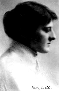
Mary Gladys Webb was an English romance novelist and poet of the early 20th century, whose work is set chiefly in the Shropshire countryside and among Shropshire characters and people whom she knew. Her novels have been successfully dramatized, most notably the film Gone to Earth in 1950 by Michael Powell and Emeric Pressburger based on the novel of the same title. The novels are thought to have inspired the famous parody Cold Comfort Farm (1932) by Stella Gibbons.

<span class="mw-page-title-main">Kettle (landform)</span> Depression or hole in an outwash plain formed by retreating glaciers or draining floodwaters

A kettle is a depression or hole in an outwash plain formed by retreating glaciers or draining floodwaters. The kettles are formed as a result of blocks of dead ice left behind by retreating glaciers, which become surrounded by sediment deposited by meltwater streams as there is increased friction. The ice becomes buried in the sediment and when the ice melts, a depression is left called a kettle hole, creating a dimpled appearance on the outwash plain. Lakes often fill these kettles; these are called kettle hole lakes. Another source is the sudden drainage of an ice-dammed lake and when the block melts, the hole it leaves behind is a kettle. As the ice melts, ramparts can form around the edge of the kettle hole. The lakes that fill these holes are seldom more than 10 m (33 ft) deep and eventually fill with sediment. In acid conditions, a kettle bog may form but in alkaline conditions, it will be kettle peatland.

<span class="mw-page-title-main">Bayston Hill</span> Village and civil parish in Shropshire, England

Bayston Hill is a village and civil parish in Shropshire, England. It is 3 miles (5 km) south of the county town Shrewsbury and located on the main A49 road, the Shrewsbury to Hereford road.

<span class="mw-page-title-main">Condover</span> Human settlement in England

Condover is a village and civil parish in Shropshire, England. It is about 5 miles (8 km) south of the county town of Shrewsbury, and just east of the A49. The Cound Brook flows through the village on its way from the Stretton Hills to a confluence with the River Severn. Condover is near to the villages of Dorrington, Bayston Hill and Berrington. The population of the Condover parish was estimated as 1,972 for 2008, of which an estimated 659 live in the village of Condover itself. The actual population measured at the 2011 census had fallen to 1,957.

The geology of Shropshire is very diverse with a large number of periods being represented at outcrop. The bedrock consists principally of sedimentary rocks of Palaeozoic and Mesozoic age, surrounding restricted areas of Precambrian metasedimentary and metavolcanic rocks. The county hosts in its Quaternary deposits and landforms, a significant record of recent glaciation. The exploitation of the Coal Measures and other Carboniferous age strata in the Ironbridge area made it one of the birthplaces of the Industrial Revolution. There is also a large amount of mineral wealth in the county, including lead and baryte. Quarrying is still active, with limestone for cement manufacture and concrete aggregate, sandstone, greywacke and dolerite for road aggregate, and sand and gravel for aggregate and drainage filters. Groundwater is an equally important economic resource.

<span class="mw-page-title-main">Loynton Moss</span>

Loynton Moss is a nature reserve of the Staffordshire Wildlife Trust, near the village of Woodseaves, in Staffordshire, England. It is adjacent to the Shropshire Union Canal, as it runs from nearby Norbury to High Offley.

<span class="mw-page-title-main">Delamere Forest</span>

Delamere Forest is a large wood in the village of Delamere in Cheshire, England. The woodland, which is managed by Forestry England, covers an area of 972 hectares making it the largest area of woodland in the county. It contains a mixture of deciduous and evergreen trees.

<span class="mw-page-title-main">Hydrosere</span>

A hydrosere is a plant succession which occurs in an area of fresh water such as in oxbow lakes and kettle lakes. In time, an area of open freshwater will naturally dry out, ultimately becoming woodland. During this change, a range of different landtypes such as swamp and marsh will succeed each other.

<span class="mw-page-title-main">Giant's kettle</span> Hole drilled in the rock by Eddy currents of water bearing gravel

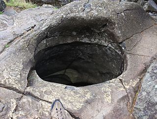
A giant's kettle, also known as either a giant's cauldron, moulin pothole, or glacial pothole, is a typically large and cylindrical pothole drilled in solid rock underlying a glacier either by water descending down a deep moulin or by gravel rotating in the bed of subglacial meltwater stream.

A mere is a shallow lake, pond, or wetland, particularly in Great Britain and other parts of western Europe.

<i>Precious Bane</i> 1924 novel by Mary Webb

Precious Bane is a historical romance by Mary Webb, first published in 1924. It won the Prix Femina Vie Heureuse Prize in 1926.

<span class="mw-page-title-main">Hatchmere</span>

Hatchmere is a small mere and nature reserve in Delamere Forest, southeast of Frodsham, Cheshire, England. It is also the name of a hamlet near the village of Norley.

<span class="mw-page-title-main">Aqualate Mere</span> Natural lake in Staffordshire, England

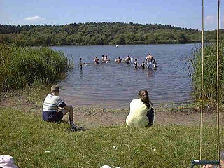
Aqualate Mere, in Staffordshire, is the largest natural lake in the English Midlands and is managed as a national nature reserve (NNR) by Natural England.

<span class="mw-page-title-main">Cooperrider-Kent Bog State Nature Preserve</span> State Nature Preserve in Portage County, Ohio

The Cooperrider-Kent Bog State Nature Preserve is state nature preserve located mainly in Kent, Ohio. The preserve surrounds the Kent Bog, a remnant of the Wisconsin Glaciation. It is a true bog with acidic waters, and unique environmental conditions have enabled it to survive. The bog contains the largest stand of tamarack trees in the state of Ohio.

<span class="mw-page-title-main">Quoisley Meres</span>

Quoisley Meres refers to two meres, Quoisley Big Mere and Quoisley Little Mere, near the village of Marbury, in Cheshire, England.

<span class="mw-page-title-main">Brown Moss</span>

Brown Moss is a Site of Special Scientific Interest, Local Nature Reserve and important wetland area rich in wildlife close to Whitchurch, Shropshire. It is open to visitors and contains a number of self-guided walking trails. The name 'moss' derives from the local word for a peat bog.

<span class="mw-page-title-main">Black Firs and Cranberry Bog</span> Nature reserve in Staffordshire

Black Firs and Cranberry Bog is a nature reserve of the Staffordshire Wildlife Trust, adjacent to Balterley Heath and about 1 mile (1.6 km) north of the village of Betley, in Staffordshire, England.

References

  1. Bomere is a SSSI Archived March 22, 2012, at the Wayback Machine
  2. "Created from Ice". Archived from the original on 1 July 2009. Retrieved 20 March 2008.
  3. Bomere Pool History
  4. Precious Bane and Bomere Pool Archived October 22, 2007, at the Wayback Machine
  5. Mais, SPB (1939). Highways and Byways In The Welsh Marches. London: MacMillan and Co Limited. p. 99.
  6. The Bomere Mammoths Archived September 29, 2011, at the Wayback Machine