Related Research Articles

Fruitvale is a village in the West Kootenay region of southeastern British Columbia. It is 16 km (9.9 mi) east of the city of Trail along Highway 3B.

Warfield is a village at the bottom of the Rossland hill, immediately west of Trail, in the West Kootenay region of southern British Columbia.
FortisBC is an electricity and natural gas distribution utility in the Canadian province of British Columbia, a subsidiary of Newfoundland-based Fortis Inc., Canada’s largest private utility company. In March 2011, Terasen Gas, British Columbia's largest natural gas distributor, was renamed FortisBC Energy Inc., as both companies are owned by Fortis Inc.
Lebahdo is an unincorporated rural community 3.6 kilometres (2.2 mi) south of Winlaw on the east side of the Slocan River in the West Kootenay region of southern British Columbia.

Duncan Lake is a man-made reservoir lake in the Kootenay region of British Columbia, Canada, formed by Duncan Dam and about 45 km in length. It is fed by the Duncan River, which forms part of the boundary between the Selkirk Mountains to the west and the Purcell Mountains to the east. Below Duncan Dam is the head of Kootenay Lake.

Corra Linn Dam is a concrete hydroelectric dam on the Kootenay River between the cities of Castlegar and Nelson, in the West Kootenay region of southern British Columbia.
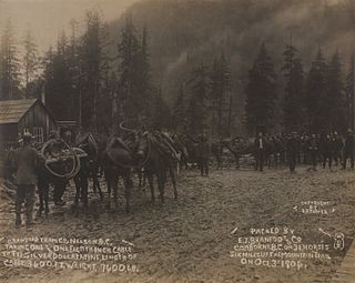
Lardeau is an unincorporated community, and former mining town and steamboat landing. The settlement is on the west shore near the head of Kootenay Lake in the West Kootenay region of southeastern British Columbia.
Yale First Nation is a First Nations government located at Yale, British Columbia. Yale has 16 distinct reserves stretching from near Sawmill Creek to American Creek, with the most southern reserve situated at Ruby Creek in the District of Kent.
Comaplix was a former mining town on the Incomappleux River in the Upper Arrow Lake area of the West Kootenay region of British Columbia. The name of the town and an adjacent mountain and creek derived from the river. Cleared in 1896, the town was surveyed and a sawmill established the next year. The suspicious 1915 fire, which levelled the buildings, largely ended the flourishing hamlet. The site, north of Beaton, on the northeast side of the lake's Beaton Arm, comprised merely concrete foundations when the Keenleyside Dam reservoir submerged the area in 1968. The small overgrown cemetery above the townsite is all that remains.
Camborne is a locality and former galena-mining town on the east side of the Incomappleux River, northeast of the head of Beaton Arm of Upper Arrow Lake, in the West Kootenay region of southern British Columbia.
Brilliant is a minor settlement across the Columbia River from Castlegar, at the confluence of the Kootenay and Columbia rivers, in the West Kootenay region of southern British Columbia. It was named by Doukhobor leader Peter (Lordly) Verigin as the village of Brilliant, describing the river as a clear diamond.
Burton is a settlement on the on the east shore of Lower Arrow Lake in the West Kootenay region of southeastern British Columbia.

Bonnington Falls were waterfalls submerged by dams on the Kootenay River between the cities of Castlegar and Nelson, in the West Kootenay region of southern British Columbia. The upper falls was named after the Falls of Clyde upper falls of Bonnington Linn.
The Kootenay Canal is a hydroelectric power station, located 19 km downstream of Nelson, British Columbia, Canada. Where the Kootenay River flows out of the reservoir formed by the Corra Linn Dam on Kootenay Lake., a canal diverts water to BC Hydro's Kootenay Canal Generating Station. Its construction was a result of the Duncan Dam and Libby Dam providing year round flows into Kootenay Lake. The powerhouse was completed in 1976.
Kaslo River is a river in the West Kootenay region of southeastern British Columbia. The village of Kaslo was founded at the river mouth on the western shore of Kootenay Lake. The river valley was mined by European and Chinese miners.
Brooklyn was on the west shore of Lower Arrow Lake, approximately 31 kilometres (19 mi) northwest of Castlegar, in the West Kootenay region of southern British Columbia. It was reputedly named after Brooklyn, New York City. The community was the construction headquarters of the Columbia and Western Railway and existed 1898–1900, before dying. A decade later, the vacant site was included in land subdivided for orchards, but was submerged when the Keenleyside Dam flooded the area in 1968.
Columbia Gardens is in the West Kootenay region of southern British Columbia. The locality is east of Trail, and near the Boundary-Waneta Border Crossing.
Lemon Creek is an unincorporated community about 9 kilometres (6 mi) south of Slocan on the east side of the Slocan River in the West Kootenay region of southern British Columbia.
References
- ↑ "Bonnington Falls (locality)". BC Geographical Names.
- ↑ "Nelson Star, 30 Jun 2013". www.nelsonstar.com.
- ↑ "1910 BC Directory". www.bccd.vpl.ca.
- ↑ "Nelson Star, 21 Nov 2015". www.nelsonstar.com.
Coordinates: 49°28′00″N117°29′00″W / 49.46667°N 117.48333°W