
This is a list of structures, sites, districts, and objects on the National Register of Historic Places in North Carolina:

This is a list of the National Register of Historic Places listings in Dakota County, Minnesota. It is intended to be a complete list of the properties and districts on the National Register of Historic Places in Dakota County, Minnesota, United States. Dakota County is located in the southeastern part of the U.S. state of Minnesota, bounded on the northeast side by the Upper Mississippi River and on the northwest by the Minnesota River. The locations of National Register properties and districts for which the latitude and longitude coordinates are included below, may be seen in an online map.

This list is of the properties and historic districts which are designated on the National Register of Historic Places or that were formerly so designated, in Hennepin County, Minnesota; there are 190 entries as of April 2023. A significant number of these properties are a result of the establishment of Fort Snelling, the development of water power at Saint Anthony Falls, and the thriving city of Minneapolis that developed around the falls. Many historic sites outside the Minneapolis city limits are associated with pioneers who established missions, farms, and schools in areas that are now suburbs in that metropolitan area.

This is a list of the National Register of Historic Places listings in Rice County, Minnesota. It is intended to be a complete list of the properties and districts on the National Register of Historic Places in Rice County, Minnesota, United States. The locations of National Register properties and districts for which the latitude and longitude coordinates are included below, may be seen in an online map.

This is a list of the National Register of Historic Places listings in Stearns County, Minnesota. It is intended to be a complete list of the properties and districts on the National Register of Historic Places in Stearns County, Minnesota, United States. The locations of National Register properties and districts for which the latitude and longitude coordinates are included below, may be seen in an online map.

This is a list of the National Register of Historic Places listings in Otter Tail County, Minnesota. It is intended to be a complete list of the properties and districts on the National Register of Historic Places in Otter Tail County, Minnesota, United States. The locations of National Register properties and districts for which the latitude and longitude coordinates are included below, may be seen in an online map.

This is a list of the National Register of Historic Places listings in Winona County, Minnesota. It is intended to be a complete list of the properties and districts on the National Register of Historic Places in Winona County, Minnesota, United States. The locations of National Register properties and districts for which the latitude and longitude coordinates are included below, may be seen in an online map.

This is a list of the National Register of Historic Places listings in Fillmore County, Minnesota. It is intended to be a complete list of the properties and districts on the National Register of Historic Places in Fillmore County, Minnesota, United States. The locations of National Register properties and districts for which the latitude and longitude coordinates are included below, may be seen in an online map.

This is a list of the National Register of Historic Places listings in Washington County, Minnesota. It is intended to be a complete list of the properties and districts on the National Register of Historic Places in Washington County, Minnesota, United States. The locations of National Register properties and districts for which the latitude and longitude coordinates are included below, may be seen in an online map.
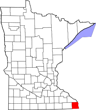
This is a list of the National Register of Historic Places listings in Houston County, Minnesota. It is intended to be a complete list of the properties and districts on the National Register of Historic Places in Houston County, Minnesota, United States. The locations of National Register properties and districts for which the latitude and longitude coordinates are included below, may be seen in an online map.

This is a list of the National Register of Historic Places listings in Newberry County, South Carolina.

This is a list of the National Register of Historic Places listings in Pope County, Minnesota. It is intended to be a complete list of the properties and districts on the National Register of Historic Places in Pope County, Minnesota, United States. The locations of National Register properties and districts for which the latitude and longitude coordinates are included below, may be seen in an online map.

The Douglass House is a historic house currently located at the corner of Front and Montgomery Streets in the Mill Hill neighborhood of the city Trenton in Mercer County, New Jersey. It served as George Washington's headquarters prior to the Battle of Princeton on January 3, 1777. Listed as the Bright–Douglass House, it was documented by the Historic American Buildings Survey in 1936, when the house was located in Mahlon Stacy Park near the Delaware River. It was added to the National Register of Historic Places on December 18, 1970, for its significance in architecture, military and social history. It was added as a contributing property to the Mill Hill Historic District on December 12, 1977.

Headquarters is an unincorporated community located within the Amwell Valley of Delaware Township in Hunterdon County, New Jersey. The settlement is centered around the intersection of Zentek Road and County Route 604. It is about 3 miles (4.8 km) from Ringoes to the east and 1 mile (1.6 km) from Sergeantsville to the west. The Headquarters Historic District was listed on the state and national registers of historic places in 2011 and had its boundary increased in 2016.

Eugene Covered Bridge, also known as County Bridge No. 75, is a historic Burr Arch Truss covered bridge located in Eugene Township, Vermillion County, Indiana. It was built in 1873, and is a single span covered timber bridge. It measures 180 feet long and 16 feet wide. The bridge spans the Big Vermilion River.
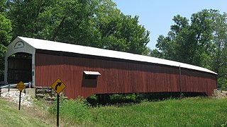
Newport Covered Bridge, also known as the Morehead Covered Bridge and County Bridge No. 67, is a historic Burr Arch Truss covered bridge located in Vermillion Township, Vermillion County, Indiana. It was built in 1885, and is a single span covered timber bridge. It measures 210 feet long and 16 feet wide. The bridge spans the Little Vermilion River.

The Timothy Mills House is a historic house built c. 1740 and located at 27 Mills Street in the town of Morristown in Morris County, New Jersey. It was documented by the Historic American Buildings Survey in 1939. It was added to the National Register of Historic Places on February 24, 1975, for its significance in architecture.


