Borrowdale

Last updated

Borrowdale
Borrowdale - Rosthwaite.jpg
Rosthwaite
Location map United Kingdom Allerdale.svg
Red pog.svg
Borrowdale
Location in Allerdale, Cumbria
Cumbria UK location map.svg
Red pog.svg
Borrowdale
Location within Cumbria
Population417 (2011)
Civil parish
  • Borrowdale
Unitary authority
Ceremonial county
Region
Country England
Sovereign state United Kingdom
Post town Keswick
Postcode district CA12
Dialling code 017687
Police Cumbria
Fire Cumbria
Ambulance North West
UK Parliament
List of places
UK
England
Cumbria
54°31′45″N3°08′45″W / 54.529167°N 3.145833°W / 54.529167; -3.145833
Derwent Water in Borrowdale at dusk Borrowdale at dusk.jpg
Derwent Water in Borrowdale at dusk
Southern aspect of Derwent Water and fells Derwent-water.jpg
Southern aspect of Derwent Water and fells

Borrowdale is a valley and civil parish in the English Lake District in Cumberland, England. It is in the ceremonial county of Cumbria, and is sometimes referred to as Cumberland Borrowdale to distinguish it from another Borrowdale in the historic county of Westmorland.

Contents

Geography

The valley rises in the central Lake District, and runs north carrying the River Derwent into the lake of Derwentwater. The waters of the river have their origins over a wide area of the central massif of the Lake District north of Esk Hause and Stake Pass. These origins include drains from the northern end of Scafell, Great End, the eastern side of the Dale Head massif, the western part of the Central Fells and all the Glaramara ridge. Near Rosthwaite the side valley of Langstrath joins the main valley from Seathwaite before the combined waters negotiate the narrow gap known as the Jaws of Borrowdale. Here it is flanked by the rocky crags of Castle Crag and Grange Fell. The valley then opens out around Grange before the river empties into Derwentwater, overlooked by Catbells, Skiddaw and Walla Crag.

Most of the mountains at the head of Borrowdale, including Scafell Pike and Great Gable, are part of the Borrowdale Volcanic Group, a geological development from the Ordovician period.

The B5289 road runs down the full length of the valley, and at the southern end crosses the Honister Pass to Buttermere. At the heart of the valley is the village of Rosthwaite, other Borrowdale villages include Stonethwaite, Seatoller, Seathwaite, and Grange.

Governance

Borrowdale is within the Copeland UK Parliamentary constituency and the North West England European Parliamentary constituency. Trudy Harrison is the Member of parliament.

Before Brexit for the European Parliament its residents voted to elect MEPs for the North West England constituency.

For Local Government purposes it is in the Cumberland unitary authority area.

Borrowdale has its own Parish Council; Borrowdale Parish Council. [1] The civil parish of Borrowdale covers a considerable area around the valley, including the southern half of Derwent Water. It includes the settlements of Grange, Rosthwaite, Seathwaite, Seatoller, Stonethwaite and Watendlath. It lies entirely within the Lake District National Park.

At the time of the 2001 census, the parish had a population of 438 people, living in 137 households. [2] [3] The 2011 Census showed that the population had declined to 417 residents among 128 households. [4]

Economy

The valley is currently a tourist location with hotels, guesthouses, holiday cottages, bed and breakfasts, youth hostels and campsites. It caters to lowland visitors as well as hillwalkers.

Sometime before 1565 (some sources say as early as 1500), a major deposit of graphite was discovered near the Seathwaite hamlet in Borrowdale parish. [5] [6] The locals found that it was useful for marking sheep. The graphite was pure and solid, and it could easily be sawn into sticks; the pencil industry was born in nearby Keswick. The graphite find remains unique. [7] [8] [9] [10] [11]

In literature

In the first of Sir Hugh Walpole's series of four novels Rogue Herries about the Herries family, Borrowdale is the site of a fictional house called Herries, the home of Francis Herries, the protagonist of the novel. Subsequent novels in the series are also largely set in Borrowdale. The valley and its surrounding mountains are described in sympathetic detail.

Walpole himself had a house at Brackenburn, Manesty, overlooking Derwent Water from 1924 until his death in 1941. Hazel Bank Country House was the fictional home of Rogue Herries and birthplace of Judith Paris. Walpole was a friend of the Simpson family, who owned Hazel Bank. This is where Walpole found the inspiration for the "Herries Chronicles".

See also

Related Research Articles

<span class="mw-page-title-main">Esk Pike</span> Fell in the Lake District, Cumbria, England

Esk Pike is a fell in the English Lake District, one of the cirque of hills forming the head of Eskdale.

<span class="mw-page-title-main">B5289 road</span> Road in the Lake District, England

The B5289 is a road in the Lake District, England. It lies in the county of Cumbria, and is an important traffic artery in the Lake District.

<span class="mw-page-title-main">Castle Crag</span> Hill in United Kingdom

Castle Crag is a hill in the North Western Fells of the English Lake District. It is the smallest hill included in Alfred Wainwright's influential Pictorial Guide to the Lakeland Fells, the only Wainwright below 1,000 feet (300 m).

<span class="mw-page-title-main">Base Brown</span> Fell in England

Base Brown is a fell in England's Lake District, near the head of the Borrowdale Valley. It forms one side of the Seathwaite Valley, and on the western side it is flanked by the hanging valley of Gillercomb.

<span class="mw-page-title-main">Seathwaite Fell</span> Fell in the Lake District, Cumbria, England

Seathwaite Fell is an area of the Lake District in Cumbria, England. It stands above the hamlet of the same name at the head of Borrowdale.

<span class="mw-page-title-main">Grange Fell</span>

Grange Fell is a small fell in the English Lake District in the county of Cumbria, situated in the Borrowdale valley overlooking the villages of Grange in Borrowdale and Rosthwaite.

<span class="mw-page-title-main">Watendlath</span> Hamlet in England

Watendlath is a hamlet and tarn in the Lake District in the English county of Cumbria, historically part of Cumberland,

<span class="mw-page-title-main">Glaramara</span> Mountain in the English Lake District, Cumbria, England

Glaramara is a fell in the English Lake District in Cumbria. It is a substantial fell that is part of a long ridge that stretches for over six kilometres from Stonethwaite in Borrowdale up to the important mountain pass of Esk Hause. The summit of Glaramara at 783 metres (2,569 ft) is the central point of this ridge, which separates the valleys of Langstrath and Grains Gill. However, the ridge has two additional fells, numerous subsidiary tops and several small tarns making its traverse an appealing and challenging walk.

<span class="mw-page-title-main">Green Gable</span> Mountain in the Lake District, England

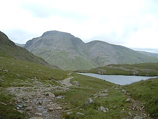
Green Gable is a fell in the English Lake District often traversed by walkers en route to its more famous neighbour Great Gable. It can be ascended from Honister Pass, Seathwaite in Borrowdale, or Ennerdale. There are good views of Gable Crag, Scafell Pike and the Buttermere valley from the summit.

<span class="mw-page-title-main">High Spy</span> Mountain in the English Lake District, Cumbria, England

High Spy is a fell in the English Lake District it is situated on the ridge that separates the Newlands Valley from Borrowdale, eight kilometres south of Keswick.

<span class="mw-page-title-main">Grey Knotts</span> Fell in the Lake District, Cumbria, England

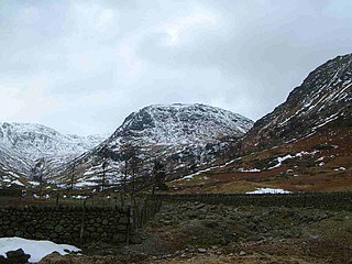
Grey Knotts is a fell in the English Lake District. It is situated one kilometre south of the B5289 road as it crosses the Honister Pass. It is well seen from mid-Borrowdale as it rises above Seatoller. Grey Knotts reaches a height of 697 metres and is part of a ridge which ascends from the woodland behind Seatoller and continues south-west and then south for four kilometres to Great Gable. The fell's name really only applies to the summit rocks, but has been adopted for the entire fell with the high ground in this area, locally known as Seatoller Fell on Ordnance Survey maps.

<span class="mw-page-title-main">Allen Crags</span> Mountain in the English Lake District, Cumbria, England

Allen Crags is a fell in the English Lake District, it lies in a group of very popular hills and is regarded as part of the Scafell group of fells. It is a hill that is frequently traversed by walkers along its ridge but is seldom climbed as the sole objective.

<span class="mw-page-title-main">Rosthwaite Fell</span>

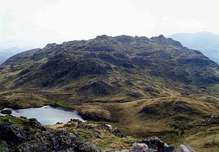
Rosthwaite Fell is a fell in the English Lake District. It is situated some 12 kilometres due south of Keswick and 2 kilometres south of the village of Rosthwaite in Borrowdale.

<span class="mw-page-title-main">Southern Fells</span>

The Southern Fells are a part of the Cumbrian Mountains in the Lake District of England. Including Scafell Pike, the highest peak in England, they occupy a broad area to the south of Great Langdale, Borrowdale and Wasdale. High and rocky towards the centre of the Lake District, the Southern Fells progressively take on a moorland character toward the south-west. In the south-east are the well-known Furness Fells, their heavily quarried flanks rising above Coniston Water.

<span class="mw-page-title-main">Seathwaite, Cumberland</span> Human settlement in England

Seathwaite is a small hamlet in the Borrowdale civil parish of Cumberland, Cumbria, North West England. It is in the Lake District near Scafell Pike and 8 miles (13 km) southwest of Keswick at the end of a minor road that heads southwest from the hamlet of Seatoller, which is where the B5289 road begins its steep climb up the pass to Honister Hause on the boundary between Borrowdale civil parish and Buttermere civil parish.

<span class="mw-page-title-main">Rosthwaite, Borrowdale</span> Human settlement in England

Rosthwaite is a settlement in the Borrowdale parish of Cumberland, Cumbria, England. It is also in Borrowdale in the English Lake District to the south of Derwent Water. The B5289 road goes through the settlement and it is to the east of the Honister Pass.

<span class="mw-page-title-main">Grange in Borrowdale</span> Human settlement in England

Grange, often called Grange in Borrowdale, is a village in Borrowdale in the English Lake District. It lies just off the B5289 road to the south of Derwent Water and 4 miles (6.4 km) south of Keswick, in the county of Cumbria, historically part of Cumberland,

Borrowdale is a civil parish in the Borough of Allerdale in Cumbria, England. It contains 39 listed buildings that are recorded in the National Heritage List for England. All the listed buildings are designated at Grade II, the lowest of the three grades, which is applied to "buildings of national importance and special interest". The parish is in the Lake District National Park, and it includes the settlements of Rosthwaite, Stonethwaite, Seathwaite, Seatoller, Grange, and Watendlath. Parts of the parish are agricultural, and much of it consists of fells and mountains. All the listed buildings are in the settlements and the valleys. A high proportion of them are, or originated as, houses, cottages, farmhouses or farm buildings. The other listed buildings are seven bridges, a former corn mill, a war memorial, and two telephone kiosks.

References

  1. "Borrowdale Parish Council".
  2. "Election Maps". Ordnance Survey. Retrieved 2 January 2010.
  3. "Census 2001 : Parish Headcounts : Allerdale". Office for National Statistics. Archived from the original on 13 June 2011. Retrieved 22 November 2009.
  4. "Parish population 2011" . Retrieved 17 June 2015.
  5. Martin Norgate & Jean Norgate (2008). "Old Cumbria Gazetteer, black lead mine, Seathwaite" . Retrieved 19 May 2008.
  6. Alfred Wainwright (2005). A Pictorial Guide to the Lakeland Fells, Western Fells. Frances Lincoln. ISBN   978-0-7112-2460-5.
  7. Parnell, J. (2009). "Genesis of the graphite deposit at Seathwaite in Borrowdale, Cumbria". Geological Magazine. 119 (5): 511–512. doi: 10.1017/S0016756800026868 .
  8. Strens, R. G. J. (2009). "The Graphite Deposit of Seathwaite in Borrowdale, Cumberland". Geological Magazine. 102 (5): 393–406. doi:10.1017/S0016756800053668. S2CID   129924824.
  9. Weis, P; Friedman, I; Gleason, J (1981). "The origin of epigenetic graphite: evidence from isotopes". Geochimica et Cosmochimica Acta. 45 (12): 2325–2332. Bibcode:1981GeCoA..45.2325W. doi:10.1016/0016-7037(81)90086-7.
  10. Ortega, L.; Millward, D.; Luque, F.J.; Barrenechea, J.F.; Beyssac, O.; Huizenga, J.-M.; Rodas, M.; Clarke, S.M. (2010). "The graphite deposit at Borrowdale (UK): A catastrophic mineralizing event associated with Ordovician magmatism" (PDF). Geochimica et Cosmochimica Acta. 74 (8): 2429–2449. Bibcode:2010GeCoA..74.2429O. doi:10.1016/j.gca.2010.01.020.
  11. Barrenechea, J. F.; Luque, F. J.; Millward, D.; Ortega, L.; Beyssac, O.; Rodas, M. (2009). "Graphite morphologies from the Borrowdale deposit (NW England, UK): Raman and SIMS data" (PDF). Contributions to Mineralogy and Petrology. 158 (1): 37–51. Bibcode:2009CoMP..158...37B. doi:10.1007/s00410-008-0369-y. S2CID   53976864.