Bosley Reservoir

Last updated

Bosley Reservoir
Bosley Reservoir.jpg
England relief location map.jpg
Red pog.svg
Bosley Reservoir
Coordinates 53°11′29″N2°7′5″W / 53.19139°N 2.11806°W / 53.19139; -2.11806 Coordinates: 53°11′29″N2°7′5″W / 53.19139°N 2.11806°W / 53.19139; -2.11806
Type Reservoir
Basin  countriesUnited Kingdom

Bosley Reservoir is a large reservoir created to feed the Macclesfield Canal system, specifically the twelve Bosley locks. It is fed from the surrounding hills, including Bosley Cloud which rises to 1,125 feet (343 m).

Contents

History

The Macclesfield Canal was surveyed by the canal engineer Thomas Telford in 1825, and was authorised by an Act of Parliament in April 1826. Although Telford was not involved in its construction, which was handled by the resident engineer William Crosley, it was typical of Telford's designs, with cuttings and embankments to create a line which was as straight and level as possible. This resulted in a canal with only two levels, connected together by a magnificently engineered flight of twelve locks at Bosley. The canal opened on 9 November 1831. [1]

The canal runs along a ridge of hills to the west of the Pennines, and is at a relatively high level. The southern section from the Trent and Mersey Canal to the foot of Bosley locks is at 400 feet (122 m) above ordnance datum (AOD) and the locks raise the level by 118 feet (36 m) so that the summit level is at 518 feet (158 m) AOD. [2] [3] This required a reservoir to be built at a high level, where few of the streams were sufficiently large to maintain its level. The obvious source of water was the River Dane, which the canal crosses at the foot of the Bosley flight, but that already supplied the Caldon Canal and so could not be used. Instead, a network of almost 5 miles (8.0 km) of feeders were built on the hills, which extracted water from streams at thirteen locations. One fed the much smaller Turks Head or Sutton reservoir, two fed into the canal directly, and the rest supplied Bosley Reservoir. At each extraction point, a gauging plate was fitted to ensure that the stream below it still received some water, and the size of the cast iron gauging plates were specified in the original Act of Parliament. [4]

The canal company advertised for tenders to build the reservoirs in August 1827, with a closing date of 3 September. The contract included the making of a large stone dam at the southern end of the reservoir site, and the various feeders which would collect the water and deliver it to the canal. When finished the reservoir covered 86 acres (35 ha) and held 410 million imperial gallons (1,900 Ml). This was supplemented by the 92 million imperial gallons (420 Ml) held in Sutton Reservoir after that was completed in 1838. With traffic on the canal less than expected, surplus was sold, with Manchester Corporation buying 200 million imperial gallons (910 Ml) between 1844 and 1846, to top up Gorton Reservoir. An Act of Parliament was obtained in 1847, which authorised the spending of £90,000 on improvements to the reservoir, but the work did not go ahead, as Manchester began obtaining its water from the Lake District shortly afterwards. [5]

The reservoir was constructed in the valley of Bosley Brook, and compensation water had to be released through the dam to maintain a flow on the brook. The outflow feeds both the brook and the 2-mile (3.2 km) feeder which runs to the top lock. Ownership of the reservoir, along with the canal, passed to the Sheffield, Ashton-under-Lyne and Manchester Railway company in 1846, and then to a series of other railway companies as amalgamations took place, before becoming the responsibility of the British Transport Commission in 1948, when the railways were nationalised. It passed to British Waterways in 1962. [5]

The capacity of the reservoir in 1959 was 367 million imperial gallons (1,670 Ml), but after a safety inspection, the water level was lowered by 7 feet (2.1 m) reducing the capacity to 212 million imperial gallons (960 Ml). With the growth of leisure traffic on the canal and the disuse of the water-saving side ponds on the locks, this capacity was proving inadequate by 1984, and a programme of raising the dam to prevent overtopping and erosion by wave action was started. When a new concrete overflow was completed in 1987, it allowed the level to be raised again by 5.5 feet (1.7 m), increasing the capacity to 321 million imperial gallons (1,460 Ml). Between 1920 and the 1960s, the island in the reservoir was owned by Yates Brothers Wine Lodges, as were the sporting rights. With the changes in water level, the island ceased to be one, and in 1988, the angling club built a causeway to it, ensuring that it will not become an island again. [5] The dry summers of the early 1990s resulted in British Waterways carrying out extensive refurbishment of the feeders which supply the reservoir. [4]

The reservoir was surveyed in 2001 by a hydrographic team working for British Waterways, as part of a three-year project to measure the capacity of all of its reservoirs. The team produced a digital map of the lake surface, which was then divided up into 98-foot (30 m) squares, and used to guide a survey boat, which spent two days taking depth soundings using a multi-beam sonar. The collected data was then used to build up accurate details of the bottom surface of the reservoir, and to create a depth capacity chart. From this it would appear that the capacity of the reservoir continues to decrease, as a result of sedimentation. It was found to be 331 million imperial gallons (1,505 Ml), around 75 per cent of the calculated volume at the time of construction. These findings present British Waterways with the difficult decision as to whether the reservoir should be dredged or not. [6]

Location

The canal is owned and maintained by Canal and River Trust, the successor to British Waterways and is popular with local anglers, birdwatchers and walkers. The valve house, which controls the discharge of water from the dam to the canal and the Bosley Brook, is built of buff gritstone, with cyclopean stonework and a semi-circular entrance. It is the original structure built in 1831 and is grade II listed, [7] as is the bridge with an elliptical horseshoe arch which carries the road across a stream at the eastern end of the dam. [8]

See also

Bibliography

Related Research Articles

Stratford-upon-Avon Canal

The Stratford-upon-Avon Canal is a canal in the south Midlands of England. The canal, which was built between 1793 and 1816, runs for 25.5 miles (41.0 km) in total, and consists of two sections. The dividing line is at Kingswood Junction, which gives access to the Grand Union Canal. Following acquisition by a railway company in 1856, it gradually declined, the southern section being un-navigable by 1945, and the northern section little better.

Llangollen Canal

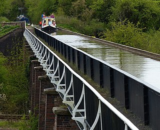
The Llangollen Canal is a navigable canal crossing the border between England and Wales. The waterway links Llangollen in Denbighshire, north Wales, with Hurleston in south Cheshire, via the town of Ellesmere, Shropshire. The name, which was coined in the 1980s, is a modern designation for parts of the historic Ellesmere Canal and the Llangollen navigable feeder, both of which became part of the Shropshire Union Canals in 1846.

Horseshoe Falls (Wales) Waterfall in About miles , west of Llangollen

Horseshoe Falls is a weir on the River Dee near Llantysilio Hall in Denbighshire, Wales, about 5 kilometres (3 mi) north-west of the town of Llangollen.

Caldon Canal

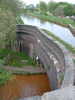
Caldon Canal is a branch of the Trent and Mersey Canal which opened in 1779. It runs 18 miles (29 km) from Etruria, Stoke-on-Trent, to Froghall, Staffordshire. The canal has 17 locks and the 76-yard (69 m) Froghall Tunnel.

Canal pound Stretch of level water impounded between two canal locks

A canal pound, reach, or level, is the stretch of level water impounded between two canal locks. Canal pounds can vary in length from the non-existent, where two or more immediately adjacent locks form a lock staircase, to many kilometres/miles.

Macclesfield Canal Canal in Cheshire, England

The Macclesfield Canal is a canal in east Cheshire, England. There were various proposals for a canal to connect the town of Macclesfield to the national network from 1765 onwards, but it was not until 1824 that a scheme came to fruition. There were already suggestions by that date that a railway would be better, but the committee that had been formed elected for a canal, and the engineer Thomas Telford endorsed the decision. The canal as built was a typical Telford canal, constructed using cut and fill, with numerous cuttings and embankments to enable it to follow as straight a course as possible, although Telford had little to do with its construction, which was managed by William Crosley.

Engine Arm

The Engine Arm or Birmingham Feeder Arm near Smethwick, West Midlands, England, is a short canal which was originally part of a feeder tunnel for a pumping engine. When the Smethwick flight of locks were reduced from six to three, the pumping engine was moved to a new site, which allowed part of the feeder tunnel to be opened up and made navigable, so that coal supplies for the engine could be delivered by barge. The Engine Arm also supplied the pumped water to the 473-foot (144 m) Wolverhampton level of the lowered summit. The arm was extended between 1825 and 1830 by Thomas Telford to carry water from Rotton Park Reservoir to the Old Main Line of the BCN Main Line Canal, and the Engine Arm Aqueduct was inserted to carry it over the new main line constructed at that time, which was 20 feet (6.1 m) lower. The arm is now managed by the Canal and River Trust and the basin beyond the site of the pumping station, which was replaced by a new engine house near Brasshouse Lane bridge in 1892, is used for residential moorings.

Smethwick Junction (canal)

Smethwick Junction is the name of the canal junctions where the Birmingham Canal Navigations Main Line Canal from Birmingham splits into the BCN Old Main Line and the BCN New Main Line near to Smethwick, West Midlands, England.

Hall Green Branch

The Hall Green Branch of the Trent and Mersey Canal is a canal in east Cheshire, England. It runs for one mile from Kidsgrove to Hall Green, where it makes an end-on junction with the Macclesfield Canal at Hall Green Stop Lock.

South Pennine Ring

The South Pennine Ring is an English canal ring which crosses the Pennines between Manchester and Huddersfield. It covers parts of five canals, and includes passage through the longest canal tunnel in Britain. It has only been possible to cruise it since 2002, when restoration of the Huddersfield Narrow Canal provided the return route across the Pennines.

Four Counties Ring

The Four Counties Ring is a canal ring which links the four English counties of Cheshire, Staffordshire, Shropshire and the West Midlands.

North Pennine Ring

The North Pennine Ring is a canal ring which crosses the Pennines between Manchester, Leeds and Castleford. It follows parts of five canals, and shares much of its route with the Outer Pennine Ring, which uses a different route for the southern crossing of the Pennines.

Bosley Lock Flight

Bosley Lock Flight is a flight of twelve canal locks, situated on the Macclesfield Canal at Bosley, near Macclesfield, Cheshire, England. The locks are substantially built with stone blocks, and unusually for narrow locks have mitre gates at both ends. They were each built with a side pond, which enabled some of the water to be re-used during a filling and emptying cycle. The side ponds have been disused for many years, but there are plans to reinstate one of them for demonstration purposes.

Marple Junction

Marple Junction is the name of the canal junction where the Macclesfield Canal terminates and meets the Peak Forest Canal at Marple, Greater Manchester, England.

Hurleston Junction

Hurleston Junction is the name of the canal junction where the Llangollen Canal terminates and meets the Shropshire Union Canal main line at Hurleston, Cheshire, England.

Ogley Junction Canal junction in the English Midlands

Ogley Junction, on the Staffordshire county border near Brownhills, West Midlands, England, is a historic canal junction on the Wyrley and Essington Canal where the Anglesey Branch left the main line.

Catshill Junction

Catshill Junction is a canal junction at the northern limit of the Daw End Branch Canal where it meets the Wyrley and Essington Canal main line, near Brownhills, in West Midlands, England.

Bromford Junction

Bromford Junction is a canal junction at the foot of the Spon Lane Locks where the Spon Lane Locks Branch meets the BCN New Main Line near Oldbury in the West Midlands, England.

Birmingham and Liverpool Junction Canal

The Birmingham and Liverpool Junction Canal was a canal in England which ran from Nantwich, where it joined the Chester Canal, to Autherley, where it joined the Staffordshire and Worcestershire Canal. Forming part of a major link between Liverpool and the industrial heartlands of the Midlands, the canal was opened in 1835, and merged with the Ellesmere and Chester Canal Company in 1845, which became the Shropshire Union Railways and Canal Company in the following year.

Hardings Wood Junction Canal junction in Staffordshire, England

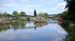
Hardings Wood Junction is a canal junction near Kidsgrove, Staffordshire, England and the point at which the Macclesfield Canal joins the Trent and Mersey Canal. It opened in 1831.

References