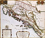
The Treaty of Berlin was signed on 13 July 1878. In the aftermath of the Russian victory against the Ottoman Empire in the Russo-Turkish War of 1877–1878, the major powers restructured the map of the Balkan region. They reversed some of the extreme gains claimed by Russia in the preliminary Treaty of San Stefano, but the Ottomans lost their major holdings in Europe. It was one of three major peace agreements in the period after the 1815 Congress of Vienna. It was the final act of the Congress of Berlin and included Great Britain and Ireland, Austria-Hungary, France, Germany, Italy, Russia and the Ottoman Empire. Chancellor of Germany Otto von Bismarck was the chairman and dominant personality.
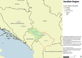
Sandžak is a historical geo-political region located in the southwestern part of Serbia and the eastern part of Montenegro. The name Sandžak derives from the Sanjak of Novi Pazar, a former Ottoman administrative district founded in 1865.

Sanjaks were administrative divisions of the Ottoman Empire. Sanjak, and the variant spellings sandjak, sanjaq and sinjaq, are English or French transliterations of the Turkish word sancak, meaning "district", "banner" or "flag". Sanjaks were also called by the Arabic word for banner or flag: لواء liwa .

The Bosnian Crisis, also known as the Annexation Crisis or the First Balkan Crisis, erupted on 5 October 1908 when Austria-Hungary announced the annexation of Bosnia and Herzegovina, territories formerly within the sovereignty of the Ottoman Empire but under Austro-Hungarian administration since 1878.

Bosnia is the northern region of Bosnia and Herzegovina, encompassing roughly 81% of the country; the other region, the southern part, is Herzegovina.
The Vilayet of Kosovo was a first-level administrative division (vilayet) of the Ottoman Empire in the Balkan Peninsula which included the current territory of Kosovo and the north-western part of the Republic of North Macedonia. The areas today comprising Sandžak (Raška) region of Serbia and Montenegro, although de jure under Ottoman control, were in fact under Austro-Hungarian occupation from 1878 until 1909, as provided under Article 25 of the Treaty of Berlin. Üsküb (Skopje) functioned as the capital of the province and the midway point between Istanbul and its European provinces. Üsküb's population of 32,000 made it the largest city in the province, followed by Prizren, also numbering at 30,000.

The Sanjak of Novi Pazar was an Ottoman sanjak that was created in 1865. It was reorganized in 1880 and 1902. The Ottoman rule in the region lasted until the First Balkan War (1912). The Sanjak of Novi Pazar included territories of present-day northeastern Montenegro and southwestern Serbia, also including some northern parts of Kosovo. In modern day terms the region is known as Sandžak.

The Vilayet of Trebizond was a first-level administrative division (vilayet) in the north-eastern part of the Ottoman Empire, corresponding to the area along the eastern Black Sea coastline and the interior highland region of the Pontic Alps.
The Vilayet of Adrianople or Vilayet of Edirne was a first-level administrative division (vilayet) of the Ottoman Empire.
The Vilayet of Scutari, Shkodër or Shkodra was a first-level administrative division (vilayet) of the Ottoman Empire that existed from 1867 to 1913, located in parts of what today is Montenegro and Albania. In the late 19th century it reportedly had an area of 13,800 square kilometres.

The Ottoman Empire era of rule in Bosnia and Herzegovina and Herzegovina lasted from 1463/1482 to 1878 de facto, and until 1908 de jure.

Bosnia and Herzegovina fell under Austro-Hungarian rule in 1878, when the Congress of Berlin approved the occupation of the Bosnia Vilayet, which officially remained part of the Ottoman Empire. Three decades later, in 1908, Austria-Hungary provoked the Bosnian Crisis by formally annexing the occupied zone, establishing the Condominium of Bosnia and Herzegovina under the joint control of Austria and Hungary.

Herzegovina is the southern and smaller of two main geographical regions of Bosnia and Herzegovina, the other being Bosnia. It has never had strictly defined geographical, cultural or historical borders, nor has it ever been defined as an administrative whole in the geopolitical and economic subdivision of Bosnia and Herzegovina.
A vilayet, also known by various other names, was a first-order administrative division of the later Ottoman Empire. It was introduced in the Vilayet Law of 21 January 1867, part of the Tanzimat reform movement initiated by the Ottoman Reform Edict of 1856. The Danube Vilayet had been specially formed in 1864 as an experiment under the leading reformer Midhat Pasha. The Vilayet Law expanded its use, but it was not until 1884 that it was applied to all of the empire's provinces. Writing for the Encyclopaedia Britannica in 1911, Vincent Henry Penalver Caillard claimed that the reform had intended to provide the provinces with greater amounts of local self-government but in fact had the effect of centralizing more power with the sultan and local Muslims at the expense of other communities.
Sanjak of Bosnia was one of the sanjaks of the Ottoman Empire established in 1463 when the lands conquered from the Bosnian Kingdom were transformed into a sanjak and Isa-Beg Isaković was appointed its first sanjakbey. In the period between 1463 and 1580 it was part of the Rumelia Eyalet. After the Bosnia Eyalet was established in 1580 the Bosnian Sanjak became its central province. Between 1864 and the Austro-Hungarian occupation of Bosnia in 1878 it was part of the Bosnia Vilayet that succeeded the Eyalet of Bosnia following administrative reforms in 1864 known as the "Vilayet Law". Although Bosnia Vilayet was officially still part of the Ottoman Empire until 1908 the Bosnian Sanjak de facto ceased to exist in 1878; when it was occupied by Austria-Hungary.

The Sanjak of Dibra, Debar, or Dibër was one of the sanjaks of the Ottoman Empire. Its capital was Debar, Macedonia. Today, the western part of its territory belongs to Albania and the eastern part to North Macedonia.

The Sanjak of Prizren was one of the sanjaks in the Ottoman Empire with Prizren as its administrative centre. It was founded immediately after Ottoman Empire captured Prizren from Serbian Despotate in 1455. The rest of the territory of Serbian Despotate was conquered after the fall of Smederevo in 1459, and divided into following sanjaks: Sanjak of Viçitrina, Sanjak of Kruševac and Sanjak of Smederevo. At the beginning of the First Balkan War in 1912, the territory of Sanjak of Prizren was occupied by the army of the Kingdom of Serbia. Based on Treaty of London signed on 30 May 1913, the territory of Sanjak of Prizren became part of Serbia.

The 1864 Vilayet Law, also known as the Provincial Reform Law, was introduced during the Tanzimat era of the late Ottoman Empire. This era of administration was marked by reform movements, with provincial movements led largely by Midhat Pasha, a key player in the Vilayet Law itself. The Vilayet Law reorganized the provinces within the empire, replacing the medieval eyalet system.

The campaign to establish Austro-Hungarian rule in Bosnia and Herzegovina lasted from 29 July to 20 October 1878 against the local resistance fighters supported by the Ottoman Empire. The Austro-Hungarian Army entered the country in two large movements: one from the north into Bosnia, and another from the south into Herzegovina. A series of battles in August culminated in the fall of Sarajevo on the 19th after a day of street-to-street fighting. In the hilly countryside a guerrilla campaign continued until the last rebel stronghold fell after their leader was captured.

The Sanjak of Durrës, also known in the west by the Italian form as the Sanjak of Durazzo, was one of the sanjaks of the Ottoman Empire. It was named after its county town Durrës. The sanjak was composed of the kazas of Durrës, Tirana, Shijak, Kavajë, and Krujë. The Sanjak of Durrës was located in the southern part of the Vilayet of Scutari and was one of its two constituent sanjaks. It bordered to the north the Sanjak of Scutari, Manastir and Dibra to the north-east, Elbasan to the east and south, and the Adriatic Sea to the west. Its terrain is generally flat and plain, and only the eastern parts of the kazas of Tirana and Kavajë are mountainous.